Mag Gaethe
Mag Gaethe
Moygay | |
|---|---|
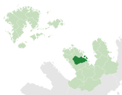
 Mag Gaethe (dark green) in Maltropia (light green) | |
| Capital | Rathyle |
| Government | |
| • Prince | Tigernach Ó Rathaille |
| Area | |
| • Total | 89.05372 km2 (34.38383 sq mi) |
| Population (2018) | |
| • Total | 12,492,859 |
| • Density | 140.28/km2 (363.3/sq mi) |
| Demonym | Mogesian |
Mag Gaethe (Irish, meaning "windy plain"), also known as Moygay, is a principality of Maltropia. It is the tenth-most populous principality, home to 12,492,859. With a landmass of 89,053.72 square kilometres, it is Maltropia's twelfth smallest principality by area.
Mag Gaethe shares borders with Cluain Áed to the north, Carbery to the west and Escir and Tyrmidra to the south.
In the eighth century, Mag Gaethe, then ruled by the Dál Ratha na hAille, owed nominal allegiance to the Uí Chairbre. They were regularly recorded as being in open revolt, however, which was a major factor in the collapse of Carberian hegemony in northwest Maltropia. Rathyle was a major centre of trade in the early middle ages, while Uisneach to the south became the greatest religious centre in Maltropia, hosting a major Church synod in 844.
