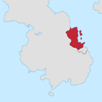
Glestingsweald
This article is incomplete because it is pending further input from participants, or it is a work-in-progress by one author. Please comment on this article's talk page to share your input, comments and questions. Note: To contribute to this article, you may need to seek help from the author(s) of this page. |
Grand Duchy of Glestingsweald Gumrîce râd Glestingawolde (Glestisc) | |
|---|---|
Coat of arms
| |
| Motto: Āstand Fæt ge Blōw | |
 Glestingsweald in Southern Mesia | |
| Capital | Magoncaister |
| Largest city | Linnburh |
| Official languages | Glestisc |
| Recognised national languages | Jomðrigan Ilænisc Umbrisc |
| Demonym(s) | Glestisc |
| Government | Parliamentary Constitutional monarchy |
| Arlon II Foultun | |
| Morven Adkins | |
| Legislature | Witan |
| Bur of Brytan | |
| Bur of Ċeorlfolc | |
| Area | |
• Total | 497,322 km2 (192,017 sq mi) |
| Population | |
• 2019 estimate | 8,157,300 |
• Density | 168/km2 (435.1/sq mi) |
| HDI (2017) | 0.892 very high |
| Currency | Feoh (GWF) |
| Date format | DD-MM-YYY CE |
| Driving side | right |
| Internet TLD | .GWF |
The Grand Duchy of Glestingsweald, commonly called Glestingsweald or Glestingawolde, is a constitutional monarchy Southeastern Flrumleohema. It is bordered to the south by Ilæniswolde, and to the east by the Mesisc Strait. Glestingawolde covers 497,322 square kilometres and has an estimated population of 8,157,300. The country comprises of ?? subdivisions with its capital in Magoncaister, located on the Cantware Peninsula in Southern Glestingawolde.
The country largely consists of flat alder glades, broken up by river valleys and temperate plains, that are home to Glestisc, Ilænisc, and Swabex populations. Located to the east are the hilly Jomðíeg Islands, home to the majority of Glestingawolde's Jomðrigan population. The majority of the population adheres to the Ceallīċ faith.
Etymology
This is an explanation of the origin of your nation's name.
History
Pre-Imperial Tribes
All prior to 300BCE
Sūdawealdh Colonialism
In approximately 300BCE, the Sūdawealdh-Héafodríce sent colonial expeditions to the coastline of Glestingawolde, with the first Sūdarigan settlements being founded on the Cantware Peninsula near modern-day Magoncaister. Of these early settlements, a fort known as Metthelle grew to be an early urban centre and most important city in the region until the mid-100s BCE. It, like many other early settlements in Glestingawolde, was primarly a hub of penal labour due to its location on the frontier. The largest efforts of penal production were primarily extraction-oriented, focusing on lead, silver, and tin mining however vineyards became an important aspect of the region's colonial economy in the latter half of Sūdarigan settlement of Glestingawolde.
Through subsequent decades, the coastal tribes of Tetinsbryg, Baswisse, and Godhelmgas, amongst several smaller tribes, were brought into the Sūdarigan tribute-sphere by means of peaceful embassies. However, despite successful attempts to subjugate the coastal tribes, much of the inland remained independent and largely uncooperative towards the Sūdarigan effort - raids were often conducted on important coastal trade routes, and a cultural divide grew during the following centuries between coastal and inland tribes. This lack of progress is attributed to the Sūdarigan focus on their larger, urban colonies in Ilæniswolde to the south. Ilæniswolde had a much smaller native population, resulting in a larger number of Sūdarigan slaves and citizens immigrating to fill the labour shortage.
By 50BCE, both Norð-Jomðíeg, Súþ-Jomðíeg, and the northern interior of modern-day Glestingawolde were under Sūdarigan influence, to varying degrees of autonomy. The Jomðíeg Islands, once home to the Clægtun tribes, had been converted into one of the region's largest clay mining industries. In the northern interior, a number of rebellious tribes had been subjected to harryings over the course of the last century. This was a result of continued resistance to urbanisation policies intended to break down the inland-coastal divides, as well as wider Sūdarigan leadership.
While regional Sūdarigan power remained centred in 'Iolanthium' in Ilæniswolde, northern power had gradually moved its focus from Metthelle towards the Sūdarigan-founded city of Linnburh, located along the northern river of Brattburne. The move is believed to be the result of military activity, and in turn administrative authority, in Glestingawolde moving northwards, with Linnburh being used as a hub.
A concentrated effort was targeted at reigning in the central inland tribes during the fifth-century CE. [then this lays the seeds for resentment over the next century that end with the indigenous peoples siezing cities up to the modern-day Glestingawolde border, straining the Ilæniswolde colony and potentially further enabling the slave revolt in the 700s.]
Post-Imperial Tribes & Jomðrigan Migration
690CE-820CE
Formation of Glestingawolde
820CE-850CE
Grand Duchy of Glestingawolde
850CE-1790CE
Kærufinnas Tribute
1790CE-1820CE
Linnburh Revolution
1820CE-1940CE
Modern Period
1940CE-Present


