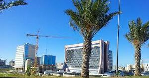
Dar Al Hamma
Dar Al Hamma
دار الحامة | |
|---|---|
| Dar Al Hamma | |
The Muntasir Economic District, in the southeastern suburbs of Dar Al Hamma. | |
| Nickname(s): الرائعة Ar Raii'ea The beautiful | |
Location within Salamat | |
| Country | Salamat |
| Province | Dar Al Hamma (province) |
| Daira | Daira of Dar Al Hamma |
| Baladiya | Baladiyat of Dar Al Hamma |
| Capital | Dar Al Hamma |
| Government | |
| • Body | Baladiyat of Dar Al Hamma |
| • Mayor | Zakaria Bashari (Front for a Democratic and United Salamat) |
| Area | |
| • Total | 229.93 km2 (88.78 sq mi) |
| • Metro | 1,138.8 km2 (439.7 sq mi) |
| Population (2022) | |
| • Total | 3,128,935 |
| • Rank | 1st |
| • Density | 13,608.2/km2 (35,245/sq mi) |
| • Metro | 5,720,324 |
| • Metro density | 5,023.1/km2 (13,010/sq mi) |
| Demonym | Hammadi |
| Time zone | -1 |
| Website | www |
Dar Al Hamma (Arabic : دار الحامة) is the biggest and the most populous city of Salamat, and the capital of Salamat. Its population (surrounding cities included) is of 5,720,324 as of 2022. It is located in the Dar Al Hamma gulf, in eastern Salamat. The local geography includes hills, Oued Hamma, which crosses the city and a coastal plain, where most of the population is concentrated.
Geography
The geography of the region is marked by three things ; A thin coastal plain, hills, which lie behind and act as a natural barrier against winds carrying sand from the desert located in Aquaria, and a river, Oued Hamma. Most of the city is located on the coastal plain, with an exception for the Casbah and the Martyrs district, established on a hill which directly faces the sea. With the districts of Dar Al Hamma occupying most of the plain, some facilities are located further out from the city because of the hills.
Climate
The climate of Dar Al Hamma is a tropical savanna climate (Koppen : Aw). The box below is more detailed ;
| Climate data for Dar Djamail Racetrack, 10°50'39.6"S 17°08'46.9"W (1990–2020 averages) | |||||||||||||
|---|---|---|---|---|---|---|---|---|---|---|---|---|---|
| Month | Jan | Feb | Mar | Apr | May | Jun | Jul | Aug | Sep | Oct | Nov | Dec | Year |
| Average high °C (°F) | 32.9 (91.2) |
32.4 (90.3) |
29.2 (84.6) |
26.9 (80.4) |
25.8 (78.4) |
25.3 (77.5) |
25.5 (77.9) |
26.2 (79.2) |
28.3 (82.9) |
29.7 (85.5) |
31.3 (88.3) |
32.0 (89.6) |
28.7 (83.7) |
| Daily mean °C (°F) | 30.5 (86.9) |
29.9 (85.8) |
27.1 (80.8) |
24.5 (76.1) |
23.8 (74.8) |
23.1 (73.6) |
22.7 (72.9) |
23.3 (73.9) |
26.6 (79.9) |
27.3 (81.1) |
28.8 (83.8) |
30.6 (87.1) |
26.5 (79.7) |
| Average low °C (°F) | 24.6 (76.3) |
23.9 (75.0) |
20.6 (69.1) |
18.3 (64.9) |
17.1 (62.8) |
16.5 (61.7) |
16.6 (61.9) |
17.4 (63.3) |
20.2 (68.4) |
22.5 (72.5) |
23.7 (74.7) |
20.5 (68.9) |
9.8 (49.6) |
| Average precipitation mm (inches) | 10.3 (0.41) |
14.5 (0.57) |
48.4 (1.91) |
52.9 (2.08) |
83.1 (3.27) |
134.5 (5.30) |
183.2 (7.21) |
160.8 (6.33) |
63.2 (2.49) |
44.4 (1.75) |
29.6 (1.17) |
8.3 (0.33) |
833.2 (32.82) |
| Average precipitation days (≥ 1.0 mm) | 1 | 2 | 10 | 13 | 19 | 27 | 26 | 27 | 21 | 14 | 5 | 1 | 166 |
| Source: weathersalamat.com.sl | |||||||||||||
