Water management of Lindenholt
This article is incomplete because it is pending further input from participants, or it is a work-in-progress by one author. Please comment on this article's talk page to share your input, comments and questions. Note: To contribute to this article, you may need to seek help from the author(s) of this page. |
A total of [x] kilometres of dikes, levees, sluices and dunes provide the water management of Lindenholt. Lindenholt, being a mostly flat and low lying country, requires artificial protection against inland rivers breaking their banks and the sea's levels rising. Coastal areas are guarded by well maintained dunes planted with marram. Additionally large portions of Lindenholt's beaches have been artificially extended. Inland a series of dikes and other features in the landscape guard Lindenholt against flooding. The Lindian government places a significant effort on watermanagement, with the Ministry for Watermanagement having received a budget of 16 billion Aurei in 2017.
History
Lindenholt's low lying features have made it prone to flooding during all of history. Safety from flooding is a relatively new concept, with the last major flooding occurring in 1949. Before this era major flooding occurred regularly. During the classical era several scholars reported that during their travels the inhabitants of Lindenholt were more concerned with fighting the water rather than each other. As engineering was not developed to the point to allow dikes and levees, the inhabitants of low lying areas who wanted to make use of the river for trade, transport, farming and fishing had to come up with ways to keep their feet dry. One such method was to create small hills on which houses were built. These wierden allowed farmers to live near the rivers during ancient times. To this day villages, towns and major cities such as Beutrecht and Reurink are centred around a wierde.
Lindenholt's relationship with the water was both a curse and a blessing. The extensive river system allowed for easy trade, and allowed for sediments to settle during the winter in areas that would be farmland during the summer. This made the Lindian soil fertile and productive.
Golden Age
As technology and engineering advanced during the late middle ages, infrastructure works to build dikes became possible. These advancements spread rapidly throughout low lying areas around rivers and culminated in most of Lindenholt being safe from river flooding during the Lindian golden age. However, every so many years flooding would occur as the still primitive dikes often could not withstand heavy rainfalls. During this time, iconic Lindian windmills also filled the landscape. Where in other parts of the world windmills were used as a means to process cereals in to flour, Jan Vollemeer invented a windmill that could drain water out of lakes using the power of the wind. Under Vollemeer's guidance the Bamester polder near Stokfort was fully drained in 1600; with operations starting in 1593.
Over the course of the Golden Age, the central government of the Republic, the local rulers and more increasingly private investors would start projects to drain lakes and marshes. By 1700 the lake riddled country now boasted a smooth look on the map; with nearly every substantial lake removed in favour of farmland and pastures. The decline of the Republic that started around the 1750's also meant the end of the windmill poldering age. The economy declined during this time, which meant that the demand for farmland also declined. Private investors, who were responsible for around half of the poldered land at the time also became poorer, and could no longer afford to support land reclamation projects. Several projects to drain parts of what is now the province of Westerland failed in the 1760's due to errors in construction and the limited technology of the time. During a flood around a thousand workers were killed. This prompted the States General to no longer allow land reclamation in Rijkslanden such as Westerland. This proved to be the last nail in the coffin for land reclamation during the Republican era in Lindenholt.
Westersea
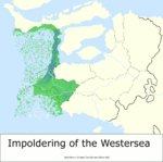
The idea to reclaim parts of what is now Westerland, Oldeniel and Hoveland was revived in the early 1800's, as the steam engine gained traction and the industrialisation of Ventismar was just getting started. The development of the steam engine made the draining of water increasingly easy over time. The ever accelerating progress of claiming the Westersea for agriculture and habitation was the largest mega project in Lindian history. Over the course of 150 years nearly 80 000 square kilometres of land was won. Most of this directly by utilising the Westersea's extreme tides, which decreased the water level in the to be drained areas significantly. Parts of the Hovestroom river were diverted to provide fresh water to the salted dry areas in an effort to flush out salts from the ground. Later the brackish water was pumped out with the same pumps, and the same process was repeated thousands of times for areas up to a thousand square kilometres.
Manpower was easy to come by for draining the Westersea. As all workers were promised significant tracts of land for them and their descendants. In the period from 1814-1863 over 300 000 people migrated from different parts of the country to work to reclaim the Westersea, with an additional 200 000 migrating there between 1870 and 1920.
Ringdijk
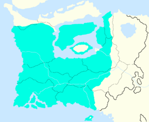
In the 1920's the government decided to stop funding the Westersea draining as the costs from what would later become the Meijerwaard project were getting higher and higher. In 1924 the government fully left whatever remained of the Westersea to drain for private parties. In 1923 the Ringdijk was finished, connecting Frêseland to Weterholt province and thereby creating a traversable loop (or ring, hence the name) around Lindenholt. Today the Ringdijk serves to protect the low lying areas that border the Sonnemeer from the Nordismar's storm surges. In addition, the Ringdijk also functions as a motorway. The R4 Rijksweg connects Stokfort to Frêseland. Nowadays there lies a high speed rail line parallel to the R4 motorway which was opened in 1999.
Early designs of the Ringdijk only featured two sluice gates where small ships could enter and leave the now separated bodies of water. The technological limitations of the time meant that substantial cargo shipping could not pass on to the harbours of cities like Artwingen. Until 1999 Artwingen could only be reached by freight shipping through the Sonnae river system. During the 1980's plans were drafted for there to be a bridge that would extend 800 metres and have a clearance of 12.5 metres that would allow most cargo ships to pass on to cities like Artwingen that were situated on the Sonnemeer. Since the bridge was part of the flood protection of the areas surrounding the Sonnemeer, the Ringdijkbrug required a way to close during storms and high tides. For this, the entire bridge's length is equipped with multiple gates of multiple differing sizes. A central command in the nearby village of Dijkebroek on the Stokfort side of the bridge is tasked with controlling the gates and the sea traffic crossing beneath the bridge.
Construction started on October 11th 1991 and was finished in September of 1999 - according to schedule. Construction would make driving on the Ringdijk impossible. Every half hour a ferry would transport passengers to the other side. Since the Ringdijk was closed, the Lindian National Railways took this opportunity to commission the construction of a high speed railroad that would eventually connect to Capsland. The construction of the bridge, railway line and reinforcement of the Ringdijk itself ended up costing around 400 million Aurei (adjusted for inflation, 2017). The Ringdijkbrug (lit. Ring-dike-bridge) was opened to the public on the 11th of October 1999 - on the 400th anniversary of Lindenholt's existence as a nation. This has also earned it the nickname of Viereeuwenbrug (lit. Four-century-bridge).
Meijerwaard
Anton Meijer first conceptualised the plans to drain parts of what is now the Sonnemeer. He was the lead engineer of the Ringdijk project during the 1920's, and drafted plans to drain substantial parts of the newly formed lake at the same time. When in the 1930's the Great Depression hit Lindenholt, the government took responsibility to solve the massive unemployment crisis that the country faced. Thousands of unemployed workers would be used as a low-cost workforce by the government in order to realise Meijer's plans. The government considered this mega project to be both beneficial in the long run, as it would add another 40 000 square kilometres of arable land and beneficial in the short run, as it would employ tens of thousands of Lindians that would directly work on draining the new province, but also to support Lindenholt's heavy industries. The Lindian heavy industry giant Dekkers was saved by these measures, as they received key government contracts for the design and construction of some of the world's largest water pumps.
The process started in 1933, with the first symbolic bucket of water being drained by Meijer himself. The last pumping station ceased reclamation operations on February 18th 1986. During this time cities like Duivenkade (named after Andries Duiven) and Meijerstad, named after Meijer who himself never lived to see the end of the impoldering, were founded on artificially heightened plateaus. On January 1 1987 the Sonnemeer Rijksland officially became the thirteenth province of Lindenholt named Meijerwaard.
The name Meijerwaard was a cause of controversy. Opponents of the name, including Meijer's own family, found that Meijer should not be honoured with the name of an entire province. They argued that the success of the project was only possible with the contribution of thousands of people; and not just Meijer. Despite this the Lindian government named the province after Meijer with the toponymical suffix -waard, meaning area surrounded by water.
Landscapes
Landscapes and their function in keeping Lindians' feet dry.
Early polders
Information on somewhat older polders from before 1800's
Westersea
Westersea polders in the provinces of Westerland, Oldeniel, and Hoveland.
Ringdijk, Sonnemeer and Meijerwaard
Information on the Ringdijk, Sonnemeer and Meijerwaard.
Baaistellingen
Information on the Baaistellingen; the works that prevent Oldeniel from flooding.
Sonnewerken
Series of dikes on the Sonnae river and flood protection gates on the mouth of the Sonnae.
Other watermanagement features
Whatever does not fall in any of the above categories.


