Yunka
Republic of Yunka República de Yunka Yunka ripuwlika | |
|---|---|
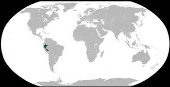
 Orthographic map of Yunka | |
| Capital | Iquitos 3°44′00″S 73°15′00″W |
| Official languages | Spanish |
| Co-official | Quechua and aimara |
| Demonym(s) | Yunqueño |
| Government | Federal Plurinational presidential republic |
• President | Gabriel Joel Núñez Castillo |
• Vice-President | Marisol Frida Duarte León |
• Chief Justice | Concha de la Lora |
| Legislature | Congress of Yunka |
| Independence from Spain | |
• Declared | July 28, 1821 |
• Battle of Ayacucho | December 9, 1824 |
• Secession of Yunka from Peru | December 7, 2022 |
| Area | |
• Total | 782,880.55 km2 (302,271.87 sq mi) |
| Population | |
• 2021 census | 3,199,427 |
| Currency | Sol (YUS) |
| Time zone | UTC-5 |
• Summer (DST) | UTC-6 |
| Driving side | right |
Yunka officially Republic of Yunka (Quechua: Ripuwlika Yunka, Aimara:Yunkawxa Ripuwlika) is a Federal presidentialist and plurinational republic located in South America. Its capital and most important economic centre is Iquitos. The territory is divided in five departaments and 32 provinces. Yunka is one of the most important economic, turistic, cultural and ecological centres in South America and in the world due that most of its territory is covered by the Amazonia, the ‘lungs of the planet’.
Etymology
Yunka is Quechua for ‘jungle’ and it makes reference to a leafy place with very high trees and many other diversity of vegetation.
Geography
Climate
According to Köppen climate classification, Yunka falls in the tropical rainforest climate or equatorial. There’s no wet or dry season and it's hot, rainy and humid all year round. The rainiest month is January, with an average of 613.9 millimetres (24.17 in) and the less rainy is April with 276.2 millimetres (10.87 in). Regarding temperatures, the hottest month is October, with a mean of 28.5 °C (83.3 °F) and daily highs exceeding 32–35 °C (90–95 °F) degrees, and the coolest month is July, with a mean of 25.2 °C (77.4 °F) and slightly cooler nights. Some nights, it can even freeze, but is very rare. The last time temperature fell above 10 °C (50 °F) was on July 2013.
| Month | Jan | Feb | Mar | Apr | May | Jun | Jul | Aug | Sep | Oct | Nov | Dec | Year |
|---|---|---|---|---|---|---|---|---|---|---|---|---|---|
| Average high °C (°F) | 32.9 (91.2) |
32.6 (90.7) |
31.3 (88.3) |
30.6 (87.1) |
30.1 (86.2) |
30.1 (86.2) |
30.4 (86.7) |
31.7 (89.1) |
32.8 (91.0) |
33.3 (91.9) |
32.9 (91.2) |
32.7 (90.9) |
31.8 (89.2) |
| Daily mean °C (°F) | 27.9 (82.2) |
27.5 (81.5) |
26.3 (79.3) |
26.4 (79.5) |
25.9 (78.6) |
25.5 (77.9) |
25.2 (77.4) |
26.5 (79.7) |
27.2 (81.0) |
28.5 (83.3) |
28.2 (82.8) |
27.9 (82.2) |
26.9 (80.5) |
| Average low °C (°F) | 22.9 (73.2) |
22.4 (72.3) |
21.4 (70.5) |
21.2 (70.2) |
21.7 (71.1) |
20.9 (69.6) |
20.0 (68.0) |
21.3 (70.3) |
21.6 (70.9) |
23.7 (74.7) |
23.6 (74.5) |
23.1 (73.6) |
22.0 (71.6) |
| Average precipitation mm (inches) | 613.9 (24.17) |
348.5 (13.72) |
310.8 (12.24) |
276.2 (10.87) |
298.9 (11.77) |
303.6 (11.95) |
319.5 (12.58) |
333.8 (13.14) |
417.9 (16.45) |
467.4 (18.40) |
499.7 (19.67) |
577.9 (22.75) |
4,768.1 (187.71) |
| Average precipitation days | 22.9 | 19.8 | 18.7 | 17.6 | 18.0 | 19.2 | 19.7 | 19.6 | 19.9 | 21.5 | 21.8 | 22.4 | 241.1 |
| Average relative humidity (%) | 83.9 | 81.6 | 80.5 | 78.9 | 80.2 | 79.9 | 79.0 | 81.5 | 83.6 | 84.9 | 82.7 | 82.5 | 81.6 |
| Mean monthly sunshine hours | 229.4 | 206.2 | 213.9 | 219.0 | 235.6 | 222.0 | 251.1 | 260.4 | 273.0 | 260.4 | 240.0 | 223.2 | 2,834.2 |
| Mean daily sunshine hours | 7.4 | 7.3 | 6.9 | 7.3 | 7.6 | 7.4 | 8.1 | 8.4 | 9.1 | 8.4 | 8.0 | 7.2 | 7.8 |
Biodiversity
The Biodiversity Assessment, Monitoring and Conservation Program focused on research, monitoring, conservation and educational programs around natural gas development operations in a 6,110 square-kilometer mosaic of forest and riverine habitats within the Urubamba and Camisea River Basins. The program was active from 2010 to 2014. The Smithsonian Conservation Biology Institute's Center for Conservation and Sustainability partnered with the company conducting petroleum development in the area, along with Peruvian government entities and other stakeholders, to demonstrate that with sound planning, commitment and creative thinking, biodiversity conservation in tropical forest environments can minimize the impacts of a company's operations. Specific objectives of the BAMCP were to:
- Understand the current status of biodiversity in the area.
- Increase understanding of the impacts resulting from industrial activities.
- Integrate appropriate science and conservation-based mitigation activities into operations.
- Improve the conservation of species and habitats through the design and implementation of community-oriented biodiversity initiatives.
