Brighton
Jump to navigation
Jump to search
Democratic People's Republic of Brighton and Hove | |
|---|---|
| Motto: Inter undas et colles floremus (Latin) Between the waves and the hills we will flourish | |
 | |
| Capital | Seagullshire |
| Official languages | English |
| Demonym(s) | Brightonian |
| Area | |
• Total | 1,792 km2 (692 sq mi) |
| Currency | Brighton Pound (BRP) |
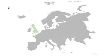
Brighton officially the Democratic People's Republic of Brighton and Hove is a partially recognized country located in the British Isles and considered as part of the United Kingdom by most of the sovereign countries. The country covers an area of 1792 square kilometres.
| Climate data for Seagullshire | |||||||||||||
|---|---|---|---|---|---|---|---|---|---|---|---|---|---|
| Month | Jan | Feb | Mar | Apr | May | Jun | Jul | Aug | Sep | Oct | Nov | Dec | Year |
| Average high °C (°F) | 24.5 (76.1) |
29.6 (85.3) |
30.2 (86.4) |
31.6 (88.9) |
37.8 (100.0) |
39.5 (103.1) |
43.9 (111.0) |
41.8 (107.2) |
38.5 (101.3) |
35.8 (96.4) |
31.5 (88.7) |
30.0 (86.0) |
34.6 (94.2) |
| Daily mean °C (°F) | 16.6 (61.9) |
19.0 (66.2) |
19.6 (67.3) |
21.2 (70.2) |
24.9 (76.8) |
27.6 (81.7) |
30.5 (86.9) |
29.5 (85.1) |
25.5 (77.9) |
23.4 (74.1) |
20.5 (68.9) |
19.6 (67.3) |
23.2 (73.7) |
| Average low °C (°F) | 8.7 (47.7) |
8.5 (47.3) |
9.1 (48.4) |
10.8 (51.4) |
12.1 (53.8) |
15.7 (60.3) |
17.1 (62.8) |
17.3 (63.1) |
12.6 (54.7) |
11.0 (51.8) |
9.5 (49.1) |
9.2 (48.6) |
11.8 (53.3) |
| Average precipitation mm (inches) | 14.2 (0.56) |
26.7 (1.05) |
30.4 (1.20) |
43.7 (1.72) |
65.3 (2.57) |
75.8 (2.98) |
77.0 (3.03) |
76.2 (3.00) |
66.4 (2.61) |
54.1 (2.13) |
41.8 (1.65) |
40.1 (1.58) |
611.7 (24.08) |
| Average relative humidity (%) | 88 | 89 | 90 | 91 | 93 | 96 | 100 | 100 | 93 | 93 | 90 | 90 | 93 |
| Source: [NAME OF THE WEBSITE] | |||||||||||||
