Erezhestan
Erezhe Republic Ереже республикасы | |
|---|---|
|
Flag | |
| Motto: Өте жақсы/Очень хорошо/Very Nice | |
| Anthem: Ережестан Мәңгі/Ережестан навсегда/Erezhestan Forever | |
| Capital | Anshilarqalasi (Formerly Okhotnikagrad) |
| Largest city | Almaqalasi (Formerly Almakaz) |
| Official languages | Erezhe |
| Also spoken | Vysokaya Rech' |
| Ethnic groups | Erezhe 42%, Transnapastaini 29%, Other Eastern Omandi Groups (Uruzi, Kirghizi, Ogbeki) 21%, Other 8% |
| Demonym(s) | Erezhe, Erezhestani |
| Government | Unitary semi-presidential republic under an authoritarian governmen |
• Father of the Nation | Ivan Pomestov (Currently in Exile) |
• Prime Minister | Fyodor Kozelov |
| Population | |
• 2023 estimate | 24,507,963 |
| GDP (nominal) | estimate |
• Total | $302.7 billion |
• Per capita | $12,613 |
| Gini | 32.3 medium |
| HDI | 0.689 medium |
| Currency | Birlik (߿) |
| Date format | yyyy/mm/dd |
| Driving side | right |
| Calling code | +796 |
Erezhestan, officially the Erezhe Republic is a Republic in Eastern Omand.
History
Erezhestan has been occupied since the Paleolithic Era. Archelogical records indicate that the horse was first domesticated in the territory of modern Erezhestan. Nomadic tribes traversed the steppes of Eastern Omand for several thousand years. Tribes began settling in the Ozen River valley in the 14th century. The city of Almaqalasi was founded as the capital of the Ozen River Khaganate in 1516. The Ozen River Khaganate ruled over several semi-soverign city states in the Ozen River valley and a confederation of nomadic tribes throughout the modern states of Erezhestan, Kirghiziastan, Ogbekistan, and Uruzistan. By the 17th century the Khaganate existed in name only with the individual cities and tribes operating with high degrees of soverignty. Between 1932 and 1947 the territory of modern Erezhestan was annexed by the Order of Soviet Socialist Republics. From 1947 to 1994 the Erezhe Soviet Socialist Republic was a de jure independent republic but functionaly a subdivision of the OSSR. In 1956 the Central Government of the OSSR divided the ESSR into independent SSRs which correspond with the modern states that make up Eastern Omand. In 1994 Erezhestan declared independence from the OSSR.
Geography
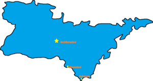
Erezhestan is the third largest nation in Omand by area. It spans from the Kavkaz mountains in the west to the Medvezhiy Strait in the east. The southern border of Erezhestan is marked by Ozen River and it extends north to the Boreal Ocean. There is significant topographical diversity in Erezhestan, but the majority of the landmass is sub-arctic steppe. The majority of the population live in the Ozen River valley.
The capital, Anshilarqalasi (Formerly Okhotnikagrad), is the largest city outside of the Ozen River valley. Previously a small industrial centre, Anshilarqalasi, was declared the capital in 1997 and has exeprienced rapid development.
The former capital, and commercial and industrial centre of the republic, is Almaqalasi (formerly Almakaz) and is located on the Ozen River at the diffluence of the Derya River.
Erezhestan's largest seaport is Bekintebe (formerly Dukhovostok) is located on the Ozen Delta in Bekin Bay on the Medvezhiy Strait.
The mountainous regions in the west are rich in coal.
The steppes and the north coast are oil producing regions heavily developed by the OSSR.
In addition to containing most of the urbanized area of the country, the Ozen River valley is fetrile and contains almost all of Erezhestan's agricultural production.

