East T'kampa
Democratic T'kampa | |
|---|---|
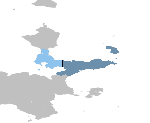
 Territory controlled by East T'kampa shown in dark blue; territory claimed but not controlled shown in light blue. | |
| Capital | Awaso |
| Largest city | Markium |
| Official languages | T'kampan |
| Official script | Pulnuya |
| Religion (2020) |
|
| Demonym(s) | T'kampan |
| Government | Unitary one-party collectivist state under a totalitarian dictatorship |
| Ratsimanjava | |
| Danoi Asalat | |
| Legislature | High Council of 42 Peasants |
| Population | |
• 2023 census | 15,854,362 |
| Currency | T'kampan sidol (₩) (TSD) |
| Time zone | UTC+9 (Asawo) |
| Date format | |
| Driving side | right |
| Calling code | +120 |
| Internet TLD | .dt |
East T'Kampa, officially Democratic T'kampa, is a country in northeastern Muambia. It constitutes the eastern half of T'kampa and borders X to its south and West T'kampa to its west along the T'kampan Demilitarized Zone. East T'kampa, like its counterpart, claims to be the sole legitimate government of all of T'kampa. The capital is the ancient city of Awaso and the largest city is Markium, which is alsothe largest city in all of T'kampa.
In 1955, republican forces consolidated the western portion of T'kampa and declared the Republic of T'kampa, which immediately put them at odds with the imperial government. Loyalist forces managed to reverse eastward advances from republican forces by 1957. In 1959, the World Congress intervened in the civil war and enforced the existing stalemate, which the emperor blamed for the continued division of the country. The imperial government was overthrown by the collectivist Workers' Movement led by Rakase Ratsimanjava in 1964, the regime of which breached the "peace line" (demilitarized zone) established by the World Congress in an attempt to unify T'kampa. This resulted in World Congress forces siding with West T'kampa, both directly intervening with tens of thousands of volunteers and logistical support.

