Bay of Albion
| Bay of Albion | |
|---|---|
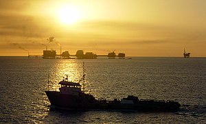
 Bay of Albion coastline near Cameron, Cartier | |
| River sources | Clarke River, Cuyoga River, Hamilton River, Mobile River, |
| Ocean/sea sources | Carpathian Ocean |
| Basin countries | Ibica |
| Max. width | 1,500 km (932.06 mi) |
| Surface area | 1,550,000 km2 (600,000 sq mi) |
| Settlements | Baton Rouge, Florence, Parkland, St. Clarke |
The Bay of Albion is an ocean basin and a marginal sea of the Carpathian Ocean, largely surrounded by Ibica. It is bounded on the east, south and west by the Bay Coast of Ibica. The Ibican states of Albion, Calahan, Cartier, Hamilton, and Petra border the Bay on the south.
Geography
The Bay of Albion is an excellent example of a passive margin. The continental shelf is quite wide at most points along the coast, most notably at Hamilton and the Cartier Peninsula. The shelf is exploited for its oil by means of offshore drilling rigs, most of which are situated in the western gulf. Another important commercial activity is fishing; major catches include red snapper, amberjack, tilefish, swordfish, and various grouper, as well as shrimp and crabs. Oysters are also harvested on a large scale from many of the bays and sounds. Other important industries along the coast include shipping, petrochemical processing and storage, military use, paper manufacture, and tourism.
The Bay's warm water temperature can feed powerful hurricanes causing extensive human death and other destruction. A hurricane will draw up cool water from the depths and making it less likely that further hurricanes will follow in its wake (warm water being one of the preconditions necessary for their formation).
The Bay is considered aseismic; however, mild tremors have been recorded throughout history (usually 5.0 or less on the Richter magnitude scale). Earthquakes may be caused by interactions between sediment loading on the sea floor and adjustment by the crust.

