Calamana
This article is incomplete because it is pending further input from participants, or it is a work-in-progress by one author. Please comment on this article's talk page to share your input, comments and questions. Note: To contribute to this article, you may need to seek help from the author(s) of this page. |
{{Infobox settlement
| name = Calamana
| native_name = Cedad Rial di Calamana
| settlement_type = City
| image_skyline = 
| image_alt =
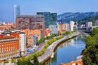
| image_caption = View of Calamana from the Jualayas River
| image_flag =  | flag_alt = Flag of Calamana
| image_seal =
| seal_alt =
| image_shield =
| shield_alt =
| etimology =
| nickname = Cattle Town and Princess Town
| motto = Corona Mygonesa cota con noza leodad.
"Coroa Mygonesa has our loyalty"
| image_map =
| map_alt =
| map_caption =
| pushpin_map =
| pushpin_map_alt =
| pushpin_map_caption =
| pushpin_label_position =
| coordinates =
| coor_pinpoint =
| coordinates_footnotes =
| subdivision_type = Country
| subdivision_name = Mygona
| subdivion_type1 = Prefecture
| subdivision_name1 = Calamana
| subdivion_type2 = Province
| subdivision_name2 = [[Gadonia]
| subdivision_type3 =
| subdivision_name3 =
| established_title =
| founder = Unknown
| seat_type =
| seat =
| governmente_footnotes =
| government_type =
| governing_body = Prefecture of Cedad Rial of Calamana
| leader_party = PDG
| leader_title = Mayor
| leader_name = Consarato E. Mongayas
| leader_title1 =
| leader_name1 =
| leader_title2 =
| leader_name2 =
| leader_title3 =
| leader_name3 =
| leader_title4 =
| leader_name4 =
| unit_pref = Metric
| area_footnotes =
| area_urban_footnotes =
| area_rural_footnotes =
| area_metro_footnotes =
| area_magnitude =
| area_note =
| area_water_percent =
| area_rank =
| area_blank1_title =
| area_blank2_title =
| area_total_km2 =
| area_land_km2 =
| area_water_km2 =
| area_urban_km2 =
| area_rural_km2 =
| area_metro_km2 =
| area_blank1_km2 =
| area_blank2_km2 =
| area_total_ha =
| area_land_ha =
| area_water_ha =
| area_urban_ha =
| area_rural_ha =
| area_metro_ha =
| area_blank1_ha =
| area_blank2_ha =
| length_km =
| width_km =
| dimensions_footnotes =
| elevation_footnotes =
| elevation_m = 114
| population_as_of =
| population_footnotes =
| population_total = 772,519
| population_density_km2 = auto
| population_note =
| population_demonym = Calamanian
| timezone1 = UTC
| utc_offset1 = +5
| postal_code_type =
| area_code =
| iso_code =
| website =
| footnotes =
}}