Ghafun
Ghafun
غافون | |
|---|---|
 Location within Salamat | |
| Country | Salamat |
| Province | Ghafunya |
| Daira | Daira of Ghafun |
| Baladiya | Baladiyat of Ghafun |
| Major city | Ghafun |
| Government | |
| • Body | Baladiyat of Ghafun |
| • Mayor | Abdellah Djaoudj (National Salvation Party) |
| Elevation | 9 m (30 ft) |
| Highest elevation | 227 m (745 ft) |
| Lowest elevation | 0 m (0 ft) |
| Population (2022) | |
| • Total | 1,981,027 |
| • Rank | 2nd |
| • Metro | 3,115,833 |
| Demonym | Ghafuni |
| Time zone | UTC-1 |
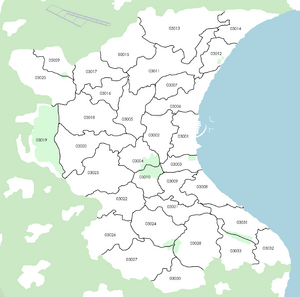
| Postal code | 03001-03033 |
| Area code | +395-03 |
| Website | www |
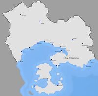
Ghafun (Arabic : غافون) is the 2nd biggest city of Salamat. Located in the west of the country, it borders the Anchor Lake and occupies an important place in naval trade in the region. Its population is of 3,115,833 as of 2022.
Geography
Ghafun is located in the Ghafun plain, which stretches from the sea to Yryel. It has occasional hills, like the Jabal Harroud area in western Ghafun which is at over 200 meters above sea level, but is mostly flat and prone to floods. The Khaliwi mountains also start just north of Ghafun. The city of Ghafun is not irrigated by rivers, but projects of canals were studied in the 70s and most recently in the 2000s.
Climate
The climate of Ghafun is a tropical savanna climate (Koppen : Aw). The box below is more detailed ;
| Climate data for Ghafun-Lakhdar Airport (1990–2020 averages) | |||||||||||||
|---|---|---|---|---|---|---|---|---|---|---|---|---|---|
| Month | Jan | Feb | Mar | Apr | May | Jun | Jul | Aug | Sep | Oct | Nov | Dec | Year |
| Record high °C (°F) | 36.1 (97.0) |
35.8 (96.4) |
35.5 (95.9) |
35.2 (95.4) |
35.0 (95.0) |
34.7 (94.5) |
34.8 (94.6) |
35.0 (95.0) |
35.2 (95.4) |
35.6 (96.1) |
35.7 (96.3) |
36.2 (97.2) |
36.2 (97.2) |
| Average high °C (°F) | 28.4 (83.1) |
27.3 (81.1) |
27.0 (80.6) |
26.5 (79.7) |
25.4 (77.7) |
25.1 (77.2) |
24.8 (76.6) |
25.5 (77.9) |
26.1 (79.0) |
26.9 (80.4) |
27.6 (81.7) |
28.7 (83.7) |
26.6 (79.9) |
| Daily mean °C (°F) | 24.9 (76.8) |
24.2 (75.6) |
23.6 (74.5) |
23.2 (73.8) |
22.7 (72.9) |
22.4 (72.3) |
22.3 (72.1) |
22.6 (72.7) |
23.3 (73.9) |
24.0 (75.2) |
24.5 (76.1) |
25.3 (77.5) |
23.6 (74.5) |
| Average low °C (°F) | 17.3 (63.1) |
17.0 (62.6) |
16.6 (61.9) |
16.2 (61.2) |
15.8 (60.4) |
15.4 (59.7) |
15.5 (59.9) |
15.9 (60.6) |
16.3 (61.3) |
16.6 (61.9) |
17.0 (62.6) |
17.4 (63.3) |
16.4 (61.5) |
| Record low °C (°F) | 13.4 (56.1) |
12.5 (54.5) |
6.4 (43.5) |
9.8 (49.6) |
11.2 (52.2) |
13.2 (55.8) |
12.6 (54.7) |
13.3 (55.9) |
10.2 (50.4) |
4.8 (40.6) |
13.5 (56.3) |
12.3 (54.1) |
4.8 (40.6) |
| Average precipitation mm (inches) | 263.1 (10.36) |
192.9 (7.59) |
110.5 (4.35) |
30.3 (1.19) |
13.7 (0.54) |
1.6 (0.06) |
5.6 (0.22) |
13.2 (0.52) |
40.8 (1.61) |
67.5 (2.66) |
169.9 (6.69) |
215.3 (8.48) |
1,124.4 (44.27) |
| Average precipitation days (≥ 1.0 mm) | 25 | 20 | 15 | 6 | 2 | 0 | 0 | 2 | 7 | 9 | 18 | 22 | 126 |
| Source: weathersalamat.com.sl | |||||||||||||
Ghafun's weather is mostly influenced by winds, which determine the temperature. Most of the time, winds blow from the southeast and bring cooler temperatures, but during the night, winds blow from the west and brings warmer temperatures. Also, at some moments of the year (early/mid-March and in mid-October), winds blow from the north, bringing cool air from the Khaliwi mountains to Ghafun and thus breaking records of cold weather. The dry season spans from April to September and the sky is mostly clear, and the wet season is mostly overcast.
Districts
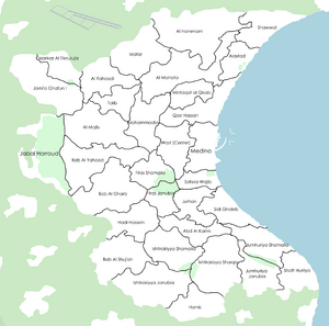
Ghafun has 33 districts. The most important districts are :
- Medina, which englobes the entire Medina of Ghafun, which is the old town.
- Wast, where most commerces and monuments are located. It is the most important part of Ghafun, as most of its administrative buildings are located inside it.
- Jami'a Ghafun I, which hosts the University of Ghafun.
- Jabal Harroud, which hosts the Jabal Harroud park, which oversees the city of Ghafun. It is a major touristic site and a protected area.
- Markaz Al Tiknulujia is the innovation pole of the city. Most startups and enterprises are located there.

