Ghafun
Ghafun
غافون | |
|---|---|
 Location within Salamat | |
| Country | Salamat |
| Province | Ghafunya |
| Daira | Daira of Ghafun |
| Baladiya | Baladiyat of Ghafun |
| Major city | Ghafun |
| Government | |
| • Body | Baladiyat of Ghafun |
| • Mayor | Abdellah Djaoudj (National Salvation Party) |
| Elevation | 9 m (30 ft) |
| Highest elevation | 227 m (745 ft) |
| Lowest elevation | 0 m (0 ft) |
| Population (2022) | |
| • Total | 1,981,027 |
| • Rank | 2nd |
| • Metro | 3,115,833 |
| Demonym | Ghafuni |
| Time zone | UTC-1 |
| Postal code | 03001-03033 |
| Area code | +395-03 |
| Website | www |
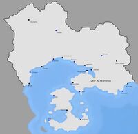
Ghafun (Arabic : غافون) is the 2nd biggest city of Salamat. Located in the west of the country, it borders the Anchor Lake and occupies an important place in naval trade in the region. Its population is of 3,115,833 as of 2022.
Geography
Ghafun is located in the Ghafun plain, which stretches from the sea to Yryel. It has occasional hills, like the Jabal Harroud area in western Ghafun which is at over 200 meters above sea level, but is mostly flat and prone to floods. The Khaliwi mountains also start just north of Ghafun. The city of Ghafun is not irrigated by rivers, but projects of canals were studied in the 70s and most recently in the 2000s.
Climate
The climate of Ghafun is a tropical savanna climate (Koppen : Aw). The box below is more detailed ;
| Climate data for Ghafun-Lakhdar Airport (1990–2020 averages) | |||||||||||||
|---|---|---|---|---|---|---|---|---|---|---|---|---|---|
| Month | Jan | Feb | Mar | Apr | May | Jun | Jul | Aug | Sep | Oct | Nov | Dec | Year |
| Record high °C (°F) | 36.1 (97.0) |
35.8 (96.4) |
35.5 (95.9) |
35.2 (95.4) |
35.0 (95.0) |
34.7 (94.5) |
34.8 (94.6) |
35.0 (95.0) |
35.2 (95.4) |
35.6 (96.1) |
35.7 (96.3) |
36.2 (97.2) |
36.2 (97.2) |
| Average high °C (°F) | 28.4 (83.1) |
27.3 (81.1) |
27.0 (80.6) |
26.5 (79.7) |
25.4 (77.7) |
25.1 (77.2) |
24.8 (76.6) |
25.5 (77.9) |
26.1 (79.0) |
26.9 (80.4) |
27.6 (81.7) |
28.7 (83.7) |
26.6 (79.9) |
| Daily mean °C (°F) | 24.9 (76.8) |
24.2 (75.6) |
23.6 (74.5) |
23.2 (73.8) |
22.7 (72.9) |
22.4 (72.3) |
22.3 (72.1) |
22.6 (72.7) |
23.3 (73.9) |
24.0 (75.2) |
24.5 (76.1) |
25.3 (77.5) |
23.6 (74.5) |
| Average low °C (°F) | 17.3 (63.1) |
17.0 (62.6) |
16.6 (61.9) |
16.2 (61.2) |
15.8 (60.4) |
15.4 (59.7) |
15.5 (59.9) |
15.9 (60.6) |
16.3 (61.3) |
16.6 (61.9) |
17.0 (62.6) |
17.4 (63.3) |
16.4 (61.5) |
| Record low °C (°F) | 13.4 (56.1) |
12.5 (54.5) |
6.4 (43.5) |
9.8 (49.6) |
11.2 (52.2) |
13.2 (55.8) |
12.6 (54.7) |
13.3 (55.9) |
10.2 (50.4) |
4.8 (40.6) |
13.5 (56.3) |
12.3 (54.1) |
4.8 (40.6) |
| Average precipitation mm (inches) | 263.1 (10.36) |
192.9 (7.59) |
110.5 (4.35) |
30.3 (1.19) |
13.7 (0.54) |
1.6 (0.06) |
5.6 (0.22) |
13.2 (0.52) |
40.8 (1.61) |
67.5 (2.66) |
169.9 (6.69) |
215.3 (8.48) |
1,124.4 (44.27) |
| Average precipitation days (≥ 1.0 mm) | 25 | 20 | 15 | 6 | 2 | 0 | 0 | 2 | 7 | 9 | 18 | 22 | 126 |
| Source: weathersalamat.com.sl | |||||||||||||
Ghafun's weather is mostly influenced by winds, which determine the temperature. Most of the time, winds blow from the southeast and bring cooler temperatures, but during the night, winds blow from the west and brings warmer temperatures. Also, at some moments of the year (early/mid-March and in mid-October), winds blow from the north, bringing cool air from the Khaliwi mountains to Ghafun and thus breaking records of cold weather. The dry season spans from April to September and the sky is mostly clear, and the wet season is mostly overcast.
Districts
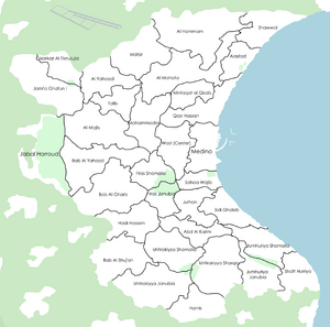
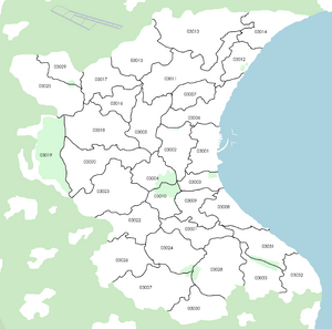
Ghafun has 33 districts. The most important districts are :
- Medina, which englobes the entire Medina of Ghafun, which is the old town.
- Wast, where most commerces and monuments are located. It is the most important part of Ghafun, as most of its administrative buildings are located inside it.
- Jami'a Ghafun I, which hosts the University of Ghafun.
- Jabal Harroud, which hosts the Jabal Harroud park, which oversees the city of Ghafun. It is a major touristic site and a protected area.
- Markaz Al Tiknulujia is the innovation pole of the city. Most startups and enterprises are located there.
Transportation
Public transportation
Public transportation in Ghafun is an essential aspect of the city's infrastructure. The city boasts a modern metro system that serves millions of commuters daily, connecting them to various parts of the city.
Metro System
The Ghafun Metro System, also known as the Ghafun Underground, is a rapid transit system that serves the city of Ghafun. The metro system currently has two lines which are the Red line and the Green line, both of which intersect at two points which make the system's hub ; the Port and Firas stations.
The Red line is the longest line in the system, running from the northeastern part of the city to the southwestern part, with a total of 19 stations. The line serves densely populated neighborhoods, shopping centers, and important municipal buildings, as well as stadiums, monuments and the port of Ghafun.
The Green line, on the other hand, runs from the northwestern part of the city to the southeastern part, with a total of 20 stations. The line connects commuters to residential areas, the university, and the city's cultural center, as well as the airport and parks.
The two lines operate from 6:00 am to 12:00 am daily, with trains departing every 5-10 minutes during peak hours and every 15 minutes during off-peak hours. The metro system is fully automated, with state-of-the-art technology ensuring efficient and reliable service to commuters.
Fares for the Ghafun Metro System are based on a distance-based system, with a minimum fare of 3 Ghafun Dinars (GHD) and a maximum fare of 8 GHD. Commuters can purchase tickets at vending machines located in each station or use rechargeable smart cards.
Other Modes of Transportation
In addition to the metro system, Ghafun also boasts other modes of transportation, such as buses, taxis, and trams. The city has a well-developed bus network, with both government-run and private companies providing services to commuters. The buses operate on various routes, connecting commuters to different parts of the city.
Taxis are also a popular mode of transportation in Ghafun, with both traditional yellow taxis and ride-hailing services available. The city has a regulated taxi fare system, with fares based on distance and time of day.
The Ghafun tram system is another mode of transportation that serves specific areas of the city. The tram network currently has two lines, connecting commuters to the city's historic district and the central business district.
Conclusion
Overall, public transportation in Ghafun plays a vital role in the city's economy and daily life of its residents. The city's modern metro system, combined with other modes of transportation, offers commuters various options for traveling throughout the city, improving connectivity, reducing traffic congestion, and promoting sustainable transportation.

