T'kampa Community
Jump to navigation
Jump to search
T'kampa | |
|---|---|
Anthem:
| |
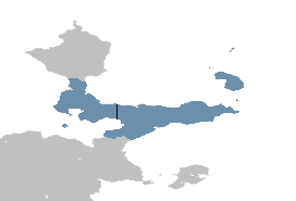
 T'kampa shown in blue | |
| Capital | |
| Largest city | Markium |
| Official languages | T'kampan |
| Demonym(s) | T'kampan |
| Government | In dispute between West T'kampa and East T'kampa |
| Raro Rutkemenmi | |
| Riyoto Ratsimanjava | |
| Shasa Moso | |
| Danoi Asalat | |
| Legislature | |
| Area | |
• Total | 223,172 km2 (86,167 sq mi) |
| Population | |
• 2017 estimate | 77,000,000 |
• Density | 349.06/km2 (904.1/sq mi) |
| Time zone | T'kampa Standard Time and Asawo Time |
| Driving side | right |
| Calling code |
|
| Internet TLD | |
T'kampa is a region in the Yulur Peninsula in Northeast Muambia
Comparison of North and South Korea
| Indicator | West T'kampa | East T'kampa |
|---|---|---|
| Formal name in English | Republic of T'kampa (ROT) | Democratic T'kampa (DT) |
| Flag |  |

|
| Emblem |  |

|
| Capital | Kura | Asawo |
| Official languages | T'kampan | |
| Government | Presidential system Representative democracy |
One-party state Meritocracy |
| Leader | President of T'kampa | Secretary-General of the Peasants' Party of T'kampa |
| Formal declaration | 7 May 1968 | 20 May 1968 |
| Population (2023 est.) | 11,198,836 | 15,854,362 |
| GDP total (2019 / 2023 est.) | TBD | TBD |
| GDP/capita (2019 / 2023 est.) | TBD | TBD |
| Currency | T'kampan neto | T'kampan sidol |
| Calling code | +TBD | TBD |
| Internet TLD | .tk | .dt |
| Drives on the | right | |
| Active military personnel | 300,000 | |
| Military expenditure (2010/2022) | TBD | TBD |


