Narayanarespur
Jump to navigation
Jump to search
People's Republic of Narayanarespur जनवादी गणतन्त्र नारायणरेसपुर Janavādī Gaṇatantra Nārāyaṇaresapura ན་ལ་ཡ་ན་ལེ་སི་ཕུའུ་མི་དམངས་སྤྱི་མཐུན་རྒྱལ་ཁབ་ཡིན། Nalayanalesipu'umi mang chi tün gyalkhab yin | |
|---|---|
 | |
| Capital | Wamrongpa |
| Religion | 46.75% Buddhism 40.38% Hinduism 3.09% Christianity 1.80% Islam |
| Government | Federal socialist one-party republic |
• President | Pema Shakabpa |
• Prime Minister | Hridaya Rai |
• Dalai Lama | Tenzin Gyatso |
| Area | |
• Total | 1,421,406 km2 (548,808 sq mi) |
| Population | |
• 2151 census | 35,652,420 |
• Density | 25.08/km2 (65.0/sq mi) |
| Currency | Serjöjor (NSR) |
| Time zone | UTC+5:00 |
• Summer (DST) | UTC+6:00 |
| Driving side | left |
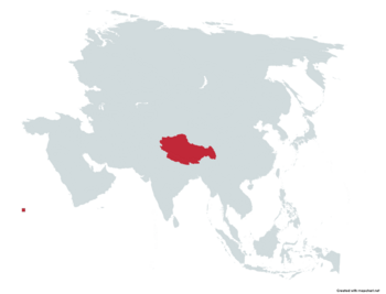
Narayanarespur officially the People's Republic of Narayanarespur is a landlocked mountainous country located in South Asia, as part of the Indian Subcontinent. It borders China to the north, India to the south, east and southeast.
| Climate data for Wamrongpa | |||||||||||||
|---|---|---|---|---|---|---|---|---|---|---|---|---|---|
| Month | Jan | Feb | Mar | Apr | May | Jun | Jul | Aug | Sep | Oct | Nov | Dec | Year |
| Average high °F (°C) | 84.0 (28.9) |
85.6 (29.8) |
87.3 (30.7) |
88.9 (31.6) |
90.5 (32.5) |
92.1 (33.4) |
93.7 (34.3) |
93.6 (34.2) |
93.4 (34.1) |
91.6 (33.1) |
91.4 (33.0) |
90.0 (32.2) |
90.2 (32.3) |
| Daily mean °F (°C) | 79.3 (26.3) |
81.0 (27.2) |
82.6 (28.1) |
84.2 (29.0) |
84.9 (29.4) |
85.6 (29.8) |
86.4 (30.2) |
85.3 (29.6) |
85.1 (29.5) |
83.3 (28.5) |
83.1 (28.4) |
82.4 (28.0) |
83.6 (28.7) |
| Average low °F (°C) | 74.7 (23.7) |
76.5 (24.7) |
78.1 (25.6) |
79.7 (26.5) |
79.5 (26.4) |
79.3 (26.3) |
79.2 (26.2) |
77.2 (25.1) |
76.8 (24.9) |
75.0 (23.9) |
74.8 (23.8) |
74.8 (23.8) |
77.1 (25.1) |
| Average precipitation inches (mm) | 0.00 (0.00) |
0.00 (0.00) |
0.00 (0.00) |
7.86 (199.7) |
10.97 (278.6) |
7.69 (195.3) |
5.76 (146.4) |
6.81 (173.1) |
0.0 (0.0) |
0.0 (0.0) |
0.0 (0.0) |
0.0 (0.0) |
39.09 (993.1) |
| Source: [NAME OF THE WEBSITE] | |||||||||||||
| Wamrongpa, Narayanarespur | ||||||||||||||||||||||||||||||||||||||||||||||||||||||||||||
|---|---|---|---|---|---|---|---|---|---|---|---|---|---|---|---|---|---|---|---|---|---|---|---|---|---|---|---|---|---|---|---|---|---|---|---|---|---|---|---|---|---|---|---|---|---|---|---|---|---|---|---|---|---|---|---|---|---|---|---|---|
| Climate chart (explanation) | ||||||||||||||||||||||||||||||||||||||||||||||||||||||||||||
| ||||||||||||||||||||||||||||||||||||||||||||||||||||||||||||
| ||||||||||||||||||||||||||||||||||||||||||||||||||||||||||||