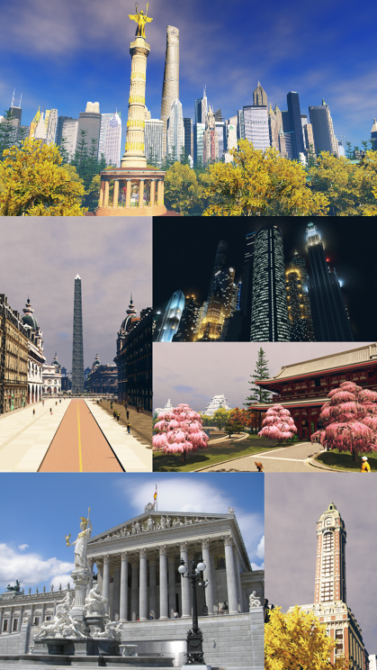
Shuto
Shuto
首都 | |
|---|---|
Capital City | |
| Shuto Metropolitan District | |
 Clockwise from top: Shibuya Skyline, Shibuya Square at Night, Imperial Park Main Gate, Daido Tower, Tayichian Imperial Diet, Shogungosho Obelisk | |
| Country | Tayichi |
| Province | Shuto Metropolitan District |
| Establishment | 1127 |
| Government | |
| • Type | Executive Mayoralty & Deliberative Assembly |
| • Body | Shuto Metropolitan Council |
| • Mayor | Masahiro Okawa (LDP-R) |
| Area | |
| • Capital City | 2,033.0 km2 (784.96 sq mi) |
| • Urban | 2,143 km2 (827.3 sq mi) |
| • Metro | 5,260 km2 (2,032 sq mi) |
| Population (2020) | |
| • Capital City | 12,712,923 |
| • Rank | 1st in Tayichi |
| • Density | 6,253/km2 (16,200/sq mi) |
| • Metro | 14,900,000 |
| • Metro density | 2,833/km2 (7,340/sq mi) |
| Postal Code | 29 areas |
| Vehicle registration | 首都(SHU) |
| GDP | 金1.5 Trillion ($926.1 Billion) |
| Per Capita | 金118,014 ($72,847) |
Shuto is the capital and most populous city within Tayichi, located at the mouth of the Taīga river, on the western coast of the nation's largest island - Hashita. Most of the city is part of the Shuto Metropolitan District, a provincial-level authority. Its inner core, which is considered to be on of the world's leading centers of finance, commerce, culture, technology, entertainment, media, academics, art and fashion, is stretched out over numerous islands that make up the Taīga River Delta. Tayichi is the center of one of the world's principal metropolitan economies.
With a population of around 12.7 million people, distributed over 785 square miles (2,033 km2), the city is the most densely populated major city in Tayichi. Shuto has more than double the population of Idaina, the nation's second-most populous city. Shuto is the demographic and economic center of the Lower Taīga Megalopolis and the Shuto Metropolitan Area, the largest metropolitan area in Tayichi by both population and urban area. The city has long been the premier gateway for immigration to Tayichi, making it the most ethnically and linguistically diverse city in the country.
Whilst the current city was founded following its castle's construction in 1127, numerous former settlements predate Shuto due to the region's strategic position at the tip of the longest and most important river in Hashita. The city rapidly grew in the 18th and early 19th century following the end of Tayichian isolation, and became the largest in 1809, but was ravaged by a destructive earthquake in 1821. Following the earthquake the city was reconstructed in the Totariku architectural style, which is mostly based on Northern and Western Amnisian architecture. A large network of wide boulevards and grand monuments spanned the new city, converging at Shogungosho, while it also became the nation's new capital in 1837. In the early 20th century Shibuya, the new financial center of the city, became the center of a skyscraper construction boom, firstly in an art-deco style. Its skyline is still one of the most defining characteristics of Shuto today.