New Bedfordville
Jump to navigation
Jump to search
Democratic Republic of New Bedfordville Bahston Pidgin: Democratic Republic of New Bedfidvil | |
|---|---|
| Motto: Pogress, Science, Leahnin (Bahston Pidgin) Progress, Science, Learning | |
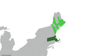
 Territory effectively controlled by the Government and the Army of New Bedfordville Territory claimed but controlled either by the United States of America or pro-USA backed separatist groups | |
| Capital | Bahston |
| Official languages | English |
| Demonym(s) | Newbedfordvillean Bedfordvillean |
| History | |
• Independence | June 8, 2024 |
• Maine War | Ongoing |
| Area | |
• Total | 37,145 sq mi (96,210 km2) |
| Time zone | UTC-6:00 |
• Summer (DST) | UTC-5:00 |
| Driving side | left |
New Bedfordville officially the Democratic Republic of New Bedfordville is an unrecognized country located in the east of North America, considered worldwide as part of the USA Commonwealth of Massachusetts, as well as the most of the Maine State.
| Climate data for Bahston | |||||||||||||
|---|---|---|---|---|---|---|---|---|---|---|---|---|---|
| Month | Jan | Feb | Mar | Apr | May | Jun | Jul | Aug | Sep | Oct | Nov | Dec | Year |
| Average high °F (°C) | 92.5 (33.6) |
94.6 (34.8) |
97.2 (36.2) |
99.7 (37.6) |
103.3 (39.6) |
108.9 (42.7) |
109.6 (43.1) |
109.0 (42.8) |
101.1 (38.4) |
99.0 (37.2) |
97.0 (36.1) |
96.1 (35.6) |
100.7 (38.1) |
| Daily mean °F (°C) | 86.0 (30.0) |
87.3 (30.7) |
88.5 (31.4) |
90.0 (32.2) |
91.8 (33.2) |
94.6 (34.8) |
95.4 (35.2) |
95.2 (35.1) |
91.2 (32.9) |
89.6 (32.0) |
88.5 (31.4) |
88.0 (31.1) |
90.5 (32.5) |
| Average low °F (°C) | 79.7 (26.5) |
79.9 (26.6) |
79.9 (26.6) |
80.2 (26.8) |
80.4 (26.9) |
80.6 (27.0) |
81.3 (27.4) |
81.3 (27.4) |
81.3 (27.4) |
80.2 (26.8) |
80.1 (26.7) |
79.9 (26.6) |
80.4 (26.9) |
| Average precipitation inches (mm) | 3.39 (86.1) |
3.26 (82.8) |
4.19 (106.5) |
3.63 (92.3) |
3.28 (83.3) |
3.93 (99.9) |
3.28 (83.3) |
3.24 (82.2) |
3.57 (90.8) |
4.02 (102.1) |
3.68 (93.5) |
4.30 (109.2) |
43.77 (1,112) |
| Source: [NAME OF THE WEBSITE] | |||||||||||||
