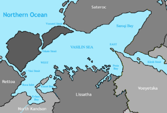
Vasilin Sea

Revision as of 01:14, 1 September 2024 by Kandson (talk | contribs) (Created page with "{{Infobox body of water | name = Vasilin Sea | native_name = | native_name_lang = | other_name = <!-- Images --> | image = VasilinSeaMap.png | alt = | caption = | image_bathymetry = | alt_bathymetry = | caption_bathymetry = <!-- Stats --> | location = | group = | coordinates = <!-- {{coord|DD|MM|SS|N|DD|MM|SS|W|region:ZZ_type:waterbody|displa...")
(diff) ← Older revision | Latest revision (diff) | Newer revision → (diff)
Jump to navigation Jump to search
Vasilin Sea
VasilinSeaMap.png
TypeSea
Primary outflowsNorthern Ocean
Basin countriesSateroc, Rettoa, North Kandson, Lissatha, Vœyetska
Surface area102,000 km2 (39,000 sq mi)
Average depth521 m (1,709 ft)
Max. depth1,130 m (3,710 ft)

The Vasilin Sea is