Chōbunten
Jump to navigation
Jump to search
People's Republic of Chōbunten | |
|---|---|
 | |
| Capital | Yumejiro |
| Demonym(s) | Chobuntenese |
| Area | |
• Total | 66,951.97 km2 (25,850.30 sq mi) |
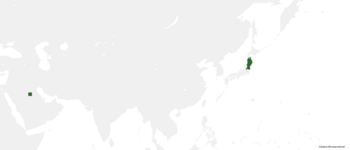
Chōbunten officially the People's Republic of Chōbunten is a country located in East Asia, comprises of the former Tōhoku region of Japan (1945-2024)
| Climate data for insert location | |||||||||||||
|---|---|---|---|---|---|---|---|---|---|---|---|---|---|
| Month | Jan | Feb | Mar | Apr | May | Jun | Jul | Aug | Sep | Oct | Nov | Dec | Year |
| Average high °C (°F) | 31.0 (87.8) |
31.4 (88.5) |
31.7 (89.1) |
31.9 (89.4) |
33.3 (91.9) |
34.3 (93.7) |
35.6 (96.1) |
35.8 (96.4) |
34.4 (93.9) |
33.6 (92.5) |
32.8 (91.0) |
32.2 (90.0) |
33.2 (91.7) |
| Daily mean °C (°F) | 30.0 (86.0) |
30.2 (86.4) |
30.4 (86.7) |
30.5 (86.9) |
31.2 (88.2) |
32.0 (89.6) |
32.7 (90.9) |
32.8 (91.0) |
32.0 (89.6) |
31.6 (88.9) |
31.1 (88.0) |
30.6 (87.1) |
31.3 (88.3) |
| Average low °C (°F) | 28.9 (84.0) |
28.9 (84.0) |
29.0 (84.2) |
29.1 (84.4) |
29.1 (84.4) |
29.6 (85.3) |
29.8 (85.6) |
29.8 (85.6) |
29.6 (85.3) |
29.5 (85.1) |
29.4 (84.9) |
29.0 (84.2) |
29.3 (84.8) |
| Average precipitation mm (inches) | 92.0 (3.62) |
53.0 (2.09) |
88.6 (3.49) |
95.2 (3.75) |
110.5 (4.35) |
124.3 (4.89) |
190.2 (7.49) |
172.3 (6.78) |
166.1 (6.54) |
151.0 (5.94) |
124.5 (4.90) |
111.2 (4.38) |
1,478.9 (58.22) |
| Source: [NAME OF THE WEBSITE] | |||||||||||||