Aasamisag: Difference between revisions
No edit summary |
No edit summary |
||
| Line 41: | Line 41: | ||
|demonym = Aasamisagong | |demonym = Aasamisagong | ||
|government_type = [[wikipedia:Directorial|Directorial]] [[wikipedia:Confederation|confederation]] | |government_type = [[wikipedia:Directorial|Directorial]] [[wikipedia:Confederation|confederation]] | ||
|leader_title1 = High Chief | |leader_title1 = Executive body | ||
| | |leader_name1 = Council of Chiefs | ||
| | |leader_title2 = High Chief | ||
| | |leader_name2 = [[Makade Waagosh]] | ||
| | |legislature = National Councils | ||
|upper_house = Council of Chiefs | |||
|lower_house = Political Council | |||
|established_event1 = <!--First key event in history of country/territory's status or formation--> | |established_event1 = <!--First key event in history of country/territory's status or formation--> | ||
|established_date1 = <!--Date of first key event--> | |established_date1 = <!--Date of first key event--> | ||
Revision as of 19:45, 31 March 2024
Confederacy of Aasamisag Aasamisagiijikiwenh Asúmísúḱíjíkíweń | |
|---|---|
|
Flag | |
Anthem: Nagamon Mizhodam Hymn to Victory | |
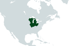
 Aasamisag (dark green) in North America | |
| Capital and largest city | Gichi Oodena |
| Official languages | Anishinaabe English |
| Recognised regional languages | Miami-Illinois Shawnee |
| Ethnic groups (1970) | 51% Anishinaabe 15% Miami-Illinois 13% Mixed/Metis 12% Shawnee 7% European 2% Other Indigenous |
| Religion (1970) | 47% Midewiwin 43% Roman Catholic 6% Traditional Faiths 4% Other/Nonreligious |
| Demonym(s) | Aasamisagong |
| Government | Directorial confederation |
• Executive body | Council of Chiefs |
• High Chief | Makade Waagosh |
| Legislature | National Councils |
| Council of Chiefs | |
| Political Council | |
| Area | |
• Total | 300,000 sq mi (780,000 km2) |
| Population | |
• 1971 estimate | 11,703,291 |
• 1970 census | 11,698,505 |
| GDP (PPP) | estimate |
• Total | £43 billion |
| Currency | Zhooniyaa (ZHN) |
| Time zone | Aasamisag Standard Time |
| Date format | dd-mm-yyyy |
| Driving side | left |
Aasamisag (Ozhibii'igan: Asúmísúḱ), officially the Confederacy of Aasamisag and historically known as the Barrier State, or by the endonym Gichigumi ((Ozhibii'igan: Ḱíćíḱúmí), is a country in the Great Lakes region of North America, bordering Canada, Louisiana, and the United States of America. Covering more than 300,000 square miles, Aasamisag is flanked by the Ohio and Mississippi river valleys, and encircles the Great Lakes. Ruled as a confederation of numerous tribes, mainly of Anishinaabe ethnicity, the Confederacy is highly decentralised and traditional in its system of government.
Formed in the 1790s at the behest of the United Kingdom, the Confederacy was originally intended as a buffer state between the British areas of North America and the newly-formed United States. In the 19th century, Aasamisag began to take on its own identity, defending its territorial possessions in the Franco-Aasamisagong War of 1816 and forming a close alliance with Mexico. The Confederacy stayed neutral during World War I but sided with the allies during World War II. After the post-war falling-out between the European Confederation and the Soviet Union, Aasamisag opted to stay neutral. Today, Aasamisag is considered to be a Middle Power, somewhat prominent on a regional level but mostly "average" in terms of international influence. It remains militarily neutral, and has largely stayed out of the ongoing Cold War.
Name
"Aasamisag" (Ozhibii'igan: Asúmísúḱ; pronounced ah-SUH-mih-suhk) derives from the Anishinaabe word for "barrier", a literal translation of the nation's designation as a "barrier state". The nation is sometimes also referred to as "Gichigumi" (Ozhibii'igan: Ḱíćíḱúmí; pronounced kih-chih-KUH-mih), meaning "Great Lakes", and nationalist groups have advocated for this to be Aasamisag's official name.
History
The history of human activity in Aasamisag began with settlement of the western Great Lakes region by Paleo-Indians perhaps as early as 11,000 B.C.E. One early technology they developed was the use of native copper, which they would fashion into tools and other implements with "hammer stones". The first Europeans to arrive in Aasamisag were the French. Explorer Étienne Brûlé traveled through Aasamisag in 1618 searching for a route to China. Soon the French laid claim to the land and began to trade with the local natives for furs. Men called "voyageurs" would travel the rivers by canoe trading various goods for furs that would bring a high price back in Europe.
The first French explorer of Aasamisag, Étienne Brûlé, arrived around 1620. The area was part of French Canada from 1668 to 1763. In 1701, the French officer Antoine de la Mothe Cadillac, along with fifty-one additional French-Canadians, founded a settlement called Fort Pontchartrain du Détroit. When New France was defeated in the French and Indian War, it ceded the region to Britain in 1763. After the British were defeated in the American Revolutionary War, the Treaty of Paris (1783) expanded the United States' boundaries to include nearly all land east of the Mississippi River and south of Canada.
However, as tensions grew between the United States and the United Kingdom by 1805, the latter proposed the establishment of a "barrier state" in the Northwest, seeking to avert hostilities in the area. The state, as conceived of by the British, would be a confederation of mostly Anishinaabe-speaking native tribes.