Amrasia
This article is incomplete because it is pending further input from participants, or it is a work-in-progress by one author. Please comment on this article's talk page to share your input, comments and questions. Note: To contribute to this article, you may need to seek help from the author(s) of this page. |
Federation of Amrasia | |
|---|---|
 | |
| Capital | Anchorage |
| Largest city | Anchorage Petropavlovia Magadan Whitehorse |
| Official languages | None |
| Recognised national languages | English |
| Ethnic groups | By race:
|
| Religion |
|
| Demonym(s) | Amrasian |
| Government | Federal Presidential Constitutional Republic |
• President | Alfred Truman |
• Vice President | Jon Brandt |
• House Speaker | Adam Kent |
• Chief Justice | Harold Williams |
| Legislature | Congress |
| Senate | |
| House of Representatives | |
| Establishment | |
• Independence from England | August 4, 1774 |
| October 12, 2038 | |
• Federation Established | July 4, 2044 |
| Area | |
• Total | 9,309,515 km2 (3,594,424 sq mi) |
| Population | |
• 2053 estimate | 2,562,981 |
• Density | 0.275/km2 (0.7/sq mi) |
| GDP (nominal) | 2054 estimate |
• Total | $9.48 trillion |
• Per capita | $65,204 |
| HDI (2053) | 0.812 very high |
| Currency | Amrasian Dollar ($) |
| Time zone | UTC-8 to +12 (AST, MGTT and PETT) |
| Driving side | right |
| Calling code | +7 (2) |
| Internet TLD | .aa |
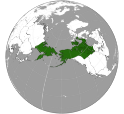
The Federation of Amrasia or commonly known as Amrasia, is a transcontinental country primarily located in North America and North Asia. It is a federation of 10 states, a federal capital district (Anchorage) and 12 indigenous reservations. Amrasia is curently the northernmost country on Earth, bordering the Arctic Sea directly and spanning across the Bering strait. It is bordered by Acadia to the east, both Nivesia and Cascadea to the south.
Etymology
The name "Amrasia" is a combination from the name of the two continents where Amrasia is located in: Americas and Asia.
America itself is derived from the Latinized version of the name of Italian explorer Amerigo Vespucci, who proposed that the lands discovered by Christopher Columbus in 1492 constituted a distinct continent. The map "Universalis Cosmographia," published in 1507 by German cartographer Martin Waldseemüller, prominently featured the label "America" for what is now South America. Flemish cartographer Gerardus Mercator later applied the term "America" to the entire Western Hemisphere on his world map in 1538.
Meanwhile, the term "Asia" finds its roots in the Ancient Greek word Ἀσία, as documented by Herodotus around 440 BCE, initially used to denote Anatolia or the Persian Empire, distinct from Greece and Egypt. Originally, it referred solely to the eastern shore of the Aegean Sea, known to the Hittites as Assuwa.
History
Indigenous peoples
The earliest inhabitants of North America migrated from Siberia through the Bering land bridge over 14,000 years ago, establishing settlements like Old Crow Flats and Bluefish Caves in Canada. These Paleo-Indian cultures, such as the Clovis culture in the southern regions, developed agriculture, settlements, and societal structures. Indigenous societies like the Algonquian peoples, Ancestral Puebloans, and the Iroquois formed diverse communities, with estimates of their pre-European population ranging from 200,000 to two million individuals.
Grand Divide
The Grand Divide was a global event occured in 2038, resulted in drastic geographical, political and societal change as well as the emergence of Metal Knights and Inhumans (such as Dreads and Dopers). The event was initially trigered by the bombing of Antarctica by a mysterious group named Kallath who released the ancient Drakonian artifact, the Pillars of Hell. The artifact was located beneath the ice sheets of Antarctica, and it was activated by Kallath members to open the gate to their planet. The pillars are capable of creating a wormhole between multiple points, but due to the pillars already tampered by Knights of the Round Table, it created enormous walls instead.
Establishment
Geography
Climate
Climate in Alaska and its surroundings are significantly colder and more variable. The Laurentian Prairies experience a continental climate, characterized by hot summers and cold winters. Average summer temperatures range from 65°F to 80°F (18°C to 27°C), while winter temperatures can drop below freezing, averaging between 5°F and 20°F (-15°C to -6°C). Moving northwest into Alaska, temperatures become even colder, with much of the state experiencing a subarctic or polar climate. Average temperatures in winter can plummet to below -20°F (-29°C) in interior regions, while coastal areas remain milder due to maritime influences.
Northward from Alaska into the Arctic region of North Asia, temperatures continue to decrease, with the area experiencing an extreme polar climate. Average temperatures rarely rise above freezing, even in summer, and can drop below -40°F (-40°C) in winter. The Arctic region also sees extended periods of darkness in winter and continuous daylight in summer due to its high latitude. These harsh conditions make the area one of the coldest inhabited regions on Earth, with limited human habitation and sparse vegetation.
Biodiversity and Conservation
Conservation efforts are currently being conducted in Alaska, the scope of conservation broadens to encompass vast wilderness areas and iconic wildlife species. Across the prairies, extensive grasslands provide habitat for diverse flora and fauna, including bison, pronghorn antelope, and the endangered whooping crane. Conservation efforts here are focused on safeguarding these unique habitats, restoring degraded landscapes, and mitigating threats such as habitat fragmentation and climate change. In Alaska, conservation priorities center on safeguarding critical habitat areas, managing human-wildlife interactions, and addressing the impacts of industrial activities and climate change on the region's diverse ecosystems.


