Antachia City: Difference between revisions

Jump to navigation Jump to search
(Created page with "{{Infobox settlement <!-- See Template:Infobox settlement for additional fields and descriptions --> | name = Antachia City | official_name = ''City of An...")
 
No edit summary
Line 1: Line 1:
{{Infobox settlement
<!-- See Template:Infobox settlement for additional fields and descriptions -->
|name                   = Antachia City
| name               = Antachia City
|native_name            = Ethria
| official_name      = ''City of Antachia''
|native_name_lang        = <!-- ISO 639-1 code e.g. "fr" for French. If more than one, use {{lang}} instead -->
| native_name        = {{lang|it|Ethria}}
|settlement_type         = [[Capital city]] and ''[[commune]]''
| settlement_type     = [[Capital city]] and ''[[commune]]''
|image_skyline           = [[File:SkylineAntachiaCity.jpg|270px]]
| image_skyline       = [[File:Rome Montage 2017.png|270px]]
|imagesize              =  
| image_caption      = Clockwise from top: the [[Colosseum]], [[St. Peter's Basilica]], [[Castel Sant'Angelo]], [[Ponte Sant'Angelo]], [[Trevi Fountain]] and the [[Pantheon, Rome|Pantheon]]
|image_alt              =
| image_flag          = [[File:Flag of Rome.svg|100px]]
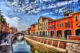
|image_caption          = Skyline of Antachia City
| image_shield        = [[File:Insigne Romanum coronatum.svg|70px]]
|image_flag              = [[File:AntachiaCityFlag.PNG|270px]]
| nickname            = {{native name|te|taone nui o te marama|italics=off}}<br />{{small|The City of the Light}}
|flag_alt                =  
{{native name|te|whakapaipai o te tangata|italics=off}}<br />{{small|The Capital of the humanity}}
|image_seal              =
Throne of St. Peter
|seal_alt                =
| etymology           = Possibly {{lang-ett|Rumon||river}} {{cross-reference|(See ''[[#Etymology|Etymology]]'').}}
|image_shield            =  
| established_title  = Founded
|shield_alt              =  
| established_date    = 753 BC
|etymology               =  
| founder            = King [[Romulus]]
|nickname                =  
<!-- maps and coordinates ------>
|motto                  =  
| image_map          = Map of comune of Rome (metropolitan city of Capital Rome, region Lazio, Italy).svg
|image_map              =  
| map_caption         = The territory of the ''comune'' (''Roma Capitale'', in red) inside the Metropolitan City of Rome (''Città Metropolitana di Roma'', in yellow). The white area in the centre is Vatican City.
|map_alt                =  
| pushpin_map        = Italy#Europe
|map_caption             =  
| pushpin_map_caption = Location within Italy##Location within Europe
|pushpin_map             =
| pushpin_relief      = yes
|pushpin_map_alt         =  
| coordinates         = {{Coord|41|53|N|12|30|E|region:IT-62_type:city(3000000)|display=inline,title}}
|pushpin_map_caption     =  
| coor_pinpoint       = <!-- to specify exact location of coordinates (was coor_type) -->
|pushpin_label_position  =  
<!-- re- location ------------------>
|coordinates             = <!-- {{coord|latitude|longitude|type:city|display=inline,title}} -->
| subdivision_type   = [[List of sovereign states|Country]]
|coor_pinpoint           =  
| subdivision_name   = {{flagicon|Italy}} {{nowrap|[[Italy]]{{efn|Excluding [[Vatican City]].}}}}
|coordinates_footnotes  =
| subdivision_type2   = [[Regions of Italy|Region]]
|subdivision_type       = Country
| subdivision_name2  = {{Flag|Lazio}}
|subdivision_name       =  
| subdivision_type3  = [[Metropolitan cities of Italy|Metropolitan city]]
|subdivision_type1      =
| subdivision_name3=
|subdivision_name1      =
Rome
|subdivision_type2       =  
<!-- government type, leaders -->
|subdivision_name2      =
| government_footnotes=
|subdivision_type3      =  
| government_type     = [[Mayor–council government|Strong Mayor–Council]]
|subdivision_name3      =
| leader_title2      = Legislature
|established_title      =  
| leader_name2        = [[City Council of Rome|Capitoline Assembly]]
|established_date        =
| leader_title1       = [[Mayor of Rome|Mayor]]
|founder                =  
| leader_name1        = [[Virginia Raggi]] ([[Five Star Movement|M5S]])
|seat_type              =
| total_type          = Total
|seat                    =
| unit_pref           = IT
|government_footnotes   =  
<!-- area ---------------------->
|government_type         =  
| area_footnotes=
|governing_body          =
| area_total_sq_mi    = 496.3
|leader_party            =  
| elevation_footnote=
|leader_title            =  
| elevation_m        = 21
|leader_name            =
| elevation_ft=
|leader_title1           =
<!-- population ---------------->
|leader_name1            =
| population_total=
|leader_title2          =
| population_as_of        = 31 December 2019
|leader_name2            =  
| population_footnotes=
|leader_title3          =
| population_density_km2  = 2236
|leader_name3            =  
| population_rank        = [[List of cities in Italy|1st in Italy]] ([[List of cities in the European Union by population within city limits|3rd in the EU]])
|leader_title4          =
| population_blank1_title = ''Comune''
|leader_name4            =  
| population_blank1      = 2,860,009<ref name="Population">{{cite web |title=I numeri di Roma Capitale |url=https://www.comune.roma.it/web-resources/cms/documents/Popolazione_2018_RC_rev.pdf |website=Comune di Roma |archive-url=https://web.archive.org/web/20200504140647/https://www.comune.roma.it/web-resources/cms/documents/Popolazione_2018_RC_rev.pdf |archive-date=4 May 2020 |date=31 December 2018 |access-date=4 May 2020 |url-status=live}}</ref>
|unit_pref               = Metric
| population_blank2_title = [[Metropolitan cities of Italy|Metropolitan City]]
<!-- ALL fields with measurements have automatic unit conversion -->
| population_blank2      = 4,342,212<ref name="PR">{{Cite web |url=http://dati.istat.it/Index.aspx?DataSetCode=DCIS_POPRES1 |title=Popolazione residente al 1° gennaio}}</ref>
<!-- for references: use <ref> tags -->
| population_demonym      = {{lang-it|romano (masculine), romana (feminine)}}<br />{{lang-en|Roman}}
|area_footnotes          =
<!-- time zone(s) -------------->
|area_urban_footnotes    = <!-- <ref> </ref> -->
| timezone1          = [[Central European Time|CET]]
|area_rural_footnotes    = <!-- <ref> </ref> -->
| utc_offset1        = +1
|area_metro_footnotes    = <!-- <ref> </ref> -->
<!-- postal codes, area code --->
|area_magnitude          = <!-- <ref> </ref> -->
| postal_code_type    = [[Postal code|CAP code(s)]]
|area_note              =  
| postal_code        = 00100; 00118 to 00199
|area_water_percent      =  
| area_code          = 06
|area_rank              =  
| website             = [https://www.comune.roma.it comune.roma.it]
|area_blank1_title      =  
| pushpin_label      = Rome
|area_blank2_title      =  
| un_locode =  
<!-- square kilometers -->
<!-- website, footnotes -------->
|area_total_km2          =  
| module              = {{Infobox UNESCO World Heritage Site
|area_land_km2          =  
| child        = yes
|area_water_km2          =  
| official_name = ''[[Historic district of Rome|Historic Centre of Rome]], the [[Properties of the Holy See#Outside Vatican City but inside Rome|Properties of the Holy See in that City Enjoying Extraterritorial Rights]] and [[Basilica of Saint Paul Outside the Walls|San Paolo Fuori le Mura]]''
|area_urban_km2          =  
| criteria      = {{UNESCO WHS type|i, ii, iii, iv, vi}}
|area_rural_km2          =  
| ID            = 91
|area_metro_km2          =
| year          = 1980
|area_blank1_km2        =  
| area          = {{convert|1431|ha|acre|abbr=on}}
|area_blank2_km2        =  
| buffer_zone=
<!-- hectares -->
}}
|area_total_ha          =  
|area_land_ha            =  
|area_water_ha          =  
|area_urban_ha          =  
|area_rural_ha          =  
|area_metro_ha          =  
|area_blank1_ha          =  
|area_blank2_ha          =  
|length_km              =  
|width_km                =
|dimensions_footnotes    =  
|elevation_footnotes    =  
|elevation_m            =  
|population_footnotes    =  
|population_as_of        =  
|population_total        =  
|population_density_km2  = auto
|population_note        =  
|population_demonym      =  
|timezone1              =  
|utc_offset1             =  
|timezone1_DST          =  
|utc_offset1_DST        =  
|postal_code_type        =  
|postal_code            =  
|area_code_type          =  
|area_code              =  
|area_codes              = for multiple area codes
|iso_code                =  
|website                = <!-- {{URL|example.com}} -->
|module                  =  
|footnotes              =
}}
}}

Revision as of 10:55, 29 January 2021

Antachia City
Ethria
SkylineAntachiaCity.jpg
Skyline of Antachia City
AntachiaCityFlag.PNG
Area codesfor multiple area codes