Esperantio: Difference between revisions
No edit summary |
No edit summary |
||
| Line 25: | Line 25: | ||
|government_type = {{wpl|List of countries by system of government|Unitary Presidential Representative Democratic Republic}} | |government_type = {{wpl|List of countries by system of government|Unitary Presidential Representative Democratic Republic}} | ||
|leader_title1 = President | |leader_title1 = President | ||
|leader_name1 = Martin | |leader_name1 = Martin Rapaporto | ||
|leader_title2 = Assistant President | |leader_title2 = Assistant President | ||
|leader_name2 = Sofia Pinto | |leader_name2 = Sofia Pinto | ||
| Line 80: | Line 80: | ||
==Geography== | ==Geography== | ||
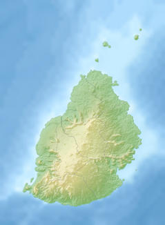
[[Image: | [[Image:Topographic map of Esperantio.png|thumb|left|239px|Topographic map of Esperantio]] | ||
[[Image: | [[Image:Canaries.png|thumb|left|239px|Mona's Point, located in the Canary Mountains.]] | ||
Esperantio, has a landmass of 2,040 km<sup>2</sup> (790 sq mi) and is located directly in the pathway of the notorious "Tropic Whip" wind that encircles the globe. It is the 177th largest nation in the world by size. The Republic of Esperantio comprises "Big Esperantio" and several outlying islands. The nation's exclusive economic zone covers about 2.3 million km<sup>2</sup> (890,000 sq mi) of the Middle Ocean, including approximately 400,000 km<sup>2</sup> (150,000 sq mi) jointly managed with nearby countries. | |||
Esperantio is | Esperantio is 2,000 km (1,200 mi) off the southeast coast of of the nearest continent, between latitudes 19°58.8'S and 20°31.7'S and longitudes 57°18.0'E and 57°46.5'E. It is 65 km (40 mi) long and 45 km (30 mi) wide. Its land area is 1,864.8 km2 (720.0 sq mi). The island is surrounded by more than 150 km (100 mi) of white sandy beaches, and the lagoons are protected from the open sea by the world's third-largest coral reef, which surrounds the island. Just off the Esperantano coast lie some 49 uninhabited islands and islets, several of which have been declared natural reserves for endangered species. | ||
Most of the country's land is relatively young geologically, having been created by volcanic activity some 8 million years ago. Together with Esperantio, Tropiko, and Soko, the island is part of the Esperantio archipelago. These islands emerged as a result of gigantic underwater volcanic eruptions that happened thousands of kilometres to the east of the continental block made up of the nearby continents. They are no longer volcanically active and the hotspot now rests under Tropiko Island. Esperantio is encircled by a broken ring of mountain ranges, varying in height from 300 to 800 metres (1,000 to 2,600 ft) above sea level. The land rises from coastal plains to a central plateau where it reaches a height of 670 m (2,200 ft); the highest peak is in the south-west, La Pinto de la Fondinto at 828 metres (2,717 ft). Streams and rivers speckle the island, many formed in the cracks created by lava flows. | |||
===Climate=== | ===Climate=== | ||
Esperantio | Esperantio's climate is tropical, with generally humid and stable conditions year-round, although weather phenomena and infrequent storms have caused instances of extreme weather. At the lower elevations, the annual precipitation varies from an average of about 50 in (130 cm) on the windward (northeastern) shore to less than 20 in (51 cm) on the (southwestern) leeward side of the island. The average temperature in Haveno, the capitol and largest city, ranges from 26 °C (78 °F) in February to 29 °C (85 °F) in August and September. The central plateau is much cooler than the surrounding coastal areas and can experience as much as twice the rainfall. The prevailing trade winds keep the east side of the island cooler and bring more rain. Occasional tropical cyclones generally occur between January and March and tend to disrupt the weather for about three days, bringing heavy rain. | ||
Rainfall is more concentrated towards the central and southern parts of the island, and lessens towards the coast in the north. The northern and western parts of the island are both slightly drier and warmer than the southern and eastern. There is no specific rainy season, although the summer months tend to be wetter, with the wettest months often being February and March. This coincides with the cyclonic season in the region. The coastal areas also experience greater lengths of sunshine across the seasons with an average of 7.5-8 hours, compared to an average of 6.5 in the interior. | |||
{{climate chart|Trachtenberg Metropolitan Area (Northern Trachtenberg) | {{climate chart|Trachtenberg Metropolitan Area (Northern Trachtenberg) | ||
Revision as of 05:17, 15 February 2024
Esperantio Respubliko Esperantio Republic of Esperantio | |
|---|---|
Motto: "Espero, Libereco kaj Paco." "Hope, Freedom, and Peace." | |
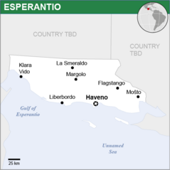 Map of Esperantio | |
| Capital and largest city | Haveno 22°10′N 108°18′W |
| Official languages | Esperanto |
| Recognised national languages | Hebrew English German Russian |
| Ethnic groups | 66.5% European 15.1% Jewish 10.2% Asian 8.2% Others |
| Demonym(s) | Esperantano |
| Government | Unitary Presidential Representative Democratic Republic |
• President | Martin Rapaporto |
• Assistant President | Sofia Pinto |
| Legislature | Parliament |
| Altakomitato | |
| Liberkonsilio | |
| Formation | |
• National Foundation Day (legendary) | June 15, 1911 CE |
• Constitution | April 2, 1929 CE |
| Area | |
• Total | 22,916 km2 (8,848 sq mi) |
• Water (%) | 3.39 |
| Population | |
• 2023 estimate | 1,421,500 |
• Density | 62/km2 (160.6/sq mi) |
| GDP (PPP) | 2022 estimate |
• Total | $771.787 billion |
• Per capita | $41,266 |
| GDP (nominal) | 2022 estimate |
• Total | $58.659 billion |
• Per capita | $42,030 |
| Gini (2023) | medium |
| HDI (2023) | 0.888 very high |
| Currency | Dolaro ($) (ESO) |
| Time zone | UTC-8 / -7 |
| Date format | yyyy-mm-dd (CE−2022) |
| Driving side | right |
| Calling code | +909 |
| Internet TLD | .ep |
Esperantio, officially known as the Republic of Esperantio (Esperanto: Respubliko Esperantio) is a country on the southern coast of Central America. It is bordered by NATION to the north, the UNNAMED Sea to the south, and NATION to the east. It also shares a water boundary with NATION to the west. It has an area of 22,970 square kilometres (8,867 sq mi) and a population of 1,421,500 (2023). Its extensive land reclamation projects have increased the combined area by approximately 10% since the country's independence, reflecting its long history of geographic development. Today, the mainland is approximately 290 km (180 mi) long and 110 km (68 mi) wide. About 42 per cent of the population lives in the capital and largest city, Haveno. Formerly one of the region's poorest countries—with a GDP per capita of about US $1,354 per year in the late 1920s—it has since transformed itself into a highly developed country, with one of the world's fastest-growing economies.
The country is heavily urbanized, with most people living in Esperantio's four major cities. The lush vegetation of these cities – even in urban areas – has earned Esperantio the nickname “forest republic”. This abundance of greenery is largely due to the country's equatorial climate, which is uniformly hot and stormy throughout the year.
Esperantio is frequently presented as an example of rapid and extraordinary economic success. After independence from NATION in 1911, annexation to NATION in 1921, then independence in 1929, Esperantio was able to become, with very few natural resources and significant socio-economic setbacks (race riots, unemployment massive, housing difficulties and access to water), one of the most developed and prosperous countries in the area, in terms of economy, education, health, security and urban planning. This prosperity, however, is based on the exploitation of short-term immigrant labor (20-30% of the active population) who generally do not benefit in any way from these living conditions.
Esperantio's history is rich and distinct, dating back more than five-hundred years. As a maritime emporium known as NAME, it served as a key trading post for several mercantile empires. Its modern era began in 1822, when Reginald Whitney established it as a shipping hub for the Western Star Line. After 89 years as a shipping colony, Esperantio gained self-governance in 1911 and became part of the NAME OF FEDERATION in 1912. However, ideological differences caused Esperantio to be expelled from the federation in 1921, and it emerged as a sovereign country.
Despite its geographic limitations, such as its small size and lack of natural ore reserves, Esperantio is home to significant offshore oil reserves, which the country has been leveraging since the 1960s. Its rapid development is based heavily on international trade and trans-continental economic agreements, with a strong emphasis on free trade, export-oriented industrialization and the accumulation of foreign direct investments, reserves and assets. Its relatively high gross national income per capita (by some estimates the largest in local economic zone) gives the country a relatively high standard of living and a respectable Human Development Index which has been increasing steadily for over 20 years.
Geography
Esperantio, has a landmass of 2,040 km2 (790 sq mi) and is located directly in the pathway of the notorious "Tropic Whip" wind that encircles the globe. It is the 177th largest nation in the world by size. The Republic of Esperantio comprises "Big Esperantio" and several outlying islands. The nation's exclusive economic zone covers about 2.3 million km2 (890,000 sq mi) of the Middle Ocean, including approximately 400,000 km2 (150,000 sq mi) jointly managed with nearby countries.
Esperantio is 2,000 km (1,200 mi) off the southeast coast of of the nearest continent, between latitudes 19°58.8'S and 20°31.7'S and longitudes 57°18.0'E and 57°46.5'E. It is 65 km (40 mi) long and 45 km (30 mi) wide. Its land area is 1,864.8 km2 (720.0 sq mi). The island is surrounded by more than 150 km (100 mi) of white sandy beaches, and the lagoons are protected from the open sea by the world's third-largest coral reef, which surrounds the island. Just off the Esperantano coast lie some 49 uninhabited islands and islets, several of which have been declared natural reserves for endangered species.
Most of the country's land is relatively young geologically, having been created by volcanic activity some 8 million years ago. Together with Esperantio, Tropiko, and Soko, the island is part of the Esperantio archipelago. These islands emerged as a result of gigantic underwater volcanic eruptions that happened thousands of kilometres to the east of the continental block made up of the nearby continents. They are no longer volcanically active and the hotspot now rests under Tropiko Island. Esperantio is encircled by a broken ring of mountain ranges, varying in height from 300 to 800 metres (1,000 to 2,600 ft) above sea level. The land rises from coastal plains to a central plateau where it reaches a height of 670 m (2,200 ft); the highest peak is in the south-west, La Pinto de la Fondinto at 828 metres (2,717 ft). Streams and rivers speckle the island, many formed in the cracks created by lava flows.
Climate
Esperantio's climate is tropical, with generally humid and stable conditions year-round, although weather phenomena and infrequent storms have caused instances of extreme weather. At the lower elevations, the annual precipitation varies from an average of about 50 in (130 cm) on the windward (northeastern) shore to less than 20 in (51 cm) on the (southwestern) leeward side of the island. The average temperature in Haveno, the capitol and largest city, ranges from 26 °C (78 °F) in February to 29 °C (85 °F) in August and September. The central plateau is much cooler than the surrounding coastal areas and can experience as much as twice the rainfall. The prevailing trade winds keep the east side of the island cooler and bring more rain. Occasional tropical cyclones generally occur between January and March and tend to disrupt the weather for about three days, bringing heavy rain.
Rainfall is more concentrated towards the central and southern parts of the island, and lessens towards the coast in the north. The northern and western parts of the island are both slightly drier and warmer than the southern and eastern. There is no specific rainy season, although the summer months tend to be wetter, with the wettest months often being February and March. This coincides with the cyclonic season in the region. The coastal areas also experience greater lengths of sunshine across the seasons with an average of 7.5-8 hours, compared to an average of 6.5 in the interior.
| Trachtenberg Metropolitan Area (Northern Trachtenberg) | ||||||||||||||||||||||||||||||||||||||||||||||||||||||||||||
|---|---|---|---|---|---|---|---|---|---|---|---|---|---|---|---|---|---|---|---|---|---|---|---|---|---|---|---|---|---|---|---|---|---|---|---|---|---|---|---|---|---|---|---|---|---|---|---|---|---|---|---|---|---|---|---|---|---|---|---|---|
| Climate chart (explanation) | ||||||||||||||||||||||||||||||||||||||||||||||||||||||||||||
| ||||||||||||||||||||||||||||||||||||||||||||||||||||||||||||
| ||||||||||||||||||||||||||||||||||||||||||||||||||||||||||||
Geology
The island of Trachtenberg is active geologically, formed on a complex convergent boundary between the Caanarian Subplate of the Central Plate to the west and north, the Strait Plate on the north-east, the Meyer-Youens Plate on the east and south, and the Urilas Plate to the southwest. Subduction changes direction at Trachtenberg. The upper part of the crust on the island is primarily made up of a series of terranes, mostly old island arcs which have been forced together by the collision of the forerunners of the Central Plate and the Urilas Plate, which is moving to the northwest. These have been further uplifted as a result of the detachment of a portion of the Central Plate as it was subducted beneath remnants of the Urilas Sea Plate, a process which left the crust under Trachtenberg more buoyant.
South of Trachtenberg, the Meyer-Youens Plate is subducting under the Urilas Plate, forming the Krukhe Volcanic Arc. The east and south of the island are a complex system of belts formed by, and part of the zone of, active collision between the North Krukhe Trough portion of the Luzon Volcanic Arc and the Central Plate, where accreted portions of the Krukhe Arc and Krukhe forearc form the sourthern Coastal Range and parallel inland Mankow Longitudinal Valley of Trachtenberg respectively.
The major seismic faults in Trachtenberg correspond to the various suture zones between the various terranes. These faults have produced several major quakes throughout the history of the island, including the 1921 Mankow Valley earthquakes in the Mankow Valley and 1969 Berlitz earthquake on the Landsteiner Fault. The most lethal was the 2005 Urilas-Spiro earthquake shifting on a fault in the Spiro District. The seismic hazard map for Tarchtenberg by the TGS shows 7/10 of the island as the highest rating (most hazardous).
Natural Resources
Natural resources on the island includes small deposits of gold, copper, coal, natural gas, limestone, marble, and asbestos. The island is 55% forest and woodland (mostly on the mountains) and 24% arable land (mostly on the plains), with 15% going to other purposes. 5% is permanent pasture and 1% is permanent crops.
Because of the intensive exploitation throughout Trachtenberg's pre-modern and modern history, the island's mineral resources (e.g. coal, gold, marble), as well as wild animal reserves (e.g. deer), have been virtually exhausted. Moreover, much of Trachtenberg's forestry resources, especially firs were harvested during early island development for the construction of housing and have only recovered slightly since then. To this day, forests do not contribute to significant timber production mainly because of concerns about production costs and environmental regulations.
Politics
Government
President since 2036
Lt. President since 2036
The politics of Trachtenberg take place in a framework of a unitary presidential representative democratic republic, whereby the President is both head of state and head of government, and of a multi-party system. The political and administrative organization of Trachtenberg comprises the federal government, and all municipalities with a population greater than 25,000. Since the nation's founding, the apparatus of the state has been set on five fundamental principles: sovereignty, citizenship, dignity of human beings, the social values of labor and freedom of enterprise, and political pluralism.
The federal government exercises control over the central government and is divided into a classic tripartite of three independent branches: executive, legislative and judicial. Executive power is exercised by the President, advised by a cabinet. Legislative power is vested upon the National Congress, a two-chamber legislature comprising the Ludowyrot (Popular Panel) and the Komizon (Commission). Judicial power is exercised by the judiciary, consisting of the Supreme Federal Court, the Superior Federal Court of Justice, and the Regional Federal Courts. The President is elected for a three-year term, with the possibility of re-election for a second and third successive term. The current president is Ayn Strauss. The previous president, Ari Rappaport, replaced Zamir Kahn after his impeachment. The President appoints the Ministers of State, who assist in government.
Trachtenberg has an unrestricted multiparty system with a large number of political parties. Some parties lack ideological consistency and it is common for komizoniks to switch parties, weakening electoral coalitions. At same time, the high number of political parties makes the Executive need to gather alliances of different political parties must piece together diverse and often ideologically incoherent coalitions to pass legislation (this is known as coalition presidentialism). For most of its democratic history, Trachtenberg has had a multi-party system complimented by proportional representation. Voting is compulsory for the literate between 18 and 70 years old and optional for illiterates and those over the age of 70. The country has more than 30 active political parties. Nine political parties are represented in Congress. It is common for politicians to switch parties, and thus the proportion of seats held by particular parties changes regularly. Almost all governmental and administrative functions are exercised by authorities and agencies affiliated to the Executive.
Parties and Elections
Elections in Trachtenberg are held for six functions of government: presidential elections (national), premiers (district-level), federal or district legislative members (local) and sheriffs (local). Apart from elections, referenda are also held occasionally.
Every Trachtsch citizen who has turned 18 has the right to vote and stand as a candidate at elections. Universal suffrage for both sexes has been applied throughout Trachtenberg since founding. In Trachtenberg, turnout rates of both local and general elections are high compared to many other countries, which usually stands higher than 70 percent. There are 300 members of the komizon who are elected for a four-year term by a party-list proportional representation system from 25 electoral districts. The Constitutional Court can strip the public financing of political parties that it deems anti-secular or having ties to terrorism, or ban their existence altogether. The electoral threshold for political parties at national level is seven percent of the votes. Smaller parties can avoid the electoral threshold by forming an alliance with other parties, in which it is sufficient that the total votes of the alliance passes 7%. Independent candidates are not subject to an electoral threshold.
After 1945, Trachtenberg operated under a multi-party system. On the right side of the Trachtsch political spectrum, parties like Blue Unity Party (BUP), Constitutional Union (CU), and People's Loyalist's (PL) once became the largest political party in Trachtenberg. Trachtsch right-wing parties are more likely to embrace principles of political ideologies such as conservatism, nationalism or state-secularism. On the left side of the spectrum, parties like Republican Populist Party (RPP), and the Industrial Coalition (DSP) once enjoyed the largest electoral success. Left-wing parties are more likely to embrace principles of socialism, multi-lingualism or religious legislation.
Economy
Economic Overview
Trachtenberg experienced healthy economic growth from 1929 to 2001 – averaging 5.4% annually. In 2001 increased pressure on the kublek, a year in which the economy contracted by 1.9%, led to a mild recession that uncovered financial sector weaknesses and forced the government to increase borrowing to support social programs. President Efren Sokolov was forced to resign after his cabinet came under fire for its slow response to the economic troubles. Trachtenberg's economy started to recover in 2002, expanding 4.2–4.4% in 2002, thanks largely to strong exports. Growth (2.2%) was dampened by the softening of the global economy in 2003, but picked up in the subsequent years owing to strong growth in nearby Sevevill, a relatively weak kublek encouraging exports, and increased domestic spending as a result of several mega projects and financial incentives for small businesses.
Today, Trachtenberg has a dynamic, capitalist, export-driven economy with gradually decreasing state involvement in investment and foreign trade. The country has been expanding its presence in international financial and commodities markets, and is considered a key economic player in the Iron Alliance. Among its primary exports, pharmaceuticals represent the largest share, followed by medical devices, agrochemicals, rubber tires, and musical instruments. Trachtenberg has been the world's largest producer of automobile tires for over 100 years. Because of its conservative financial approach and its entrepreneurial strengths, Trachtenberg suffered little compared with many of its neighbours in the 2001 economic downturn that struck the region. Unlike its neighbours, the Trachtenberg economy is dominated by small and medium-sized businesses, rather than the large business groups. The regional economic downturn, however, combined with poor policy co-ordination by the new administration and rapidly increasing bad debts in the banking system, pushed Trachtenberg into a second recession in 2032, the first whole year of negative growth since 2001. Due to the relocation of many manufacturing and labour-intensive industries to cheaper labour markets, unemployment also reached a level not seen since the 1970s oil crisis. This became a major issue in the 2032 presidential election.
Real growth in GDP has averaged about 5 per cent during the past three decades. Exports have provided the primary impetus for industrialization. The trade surplus is modest, and foreign reserves are the world's twenty-ninth largest. The official currency of Trachtenberg is the Kublek. Trachtenberg's total trade in 2008 reached an all-time high of 526.04 billion marks, according to Trachtenberg's Ministry of Finance. Both exports and imports for the year reached record levels, totaling 274.64 billion and 251.4 billion, respectively.
Debt Crisis (2032-2035)
From 2020 to 2031, Trachtenberg's economy grew at an average of over 5% per year, the third highest economic growth rate in the Region at the time. Inflation was kept reasonably low within a range of 3.4–5.7%. The kublek was pegged at 2 to the Markish Mark. Even until the eve of the regional equity crisis of 2030–2032, it featured high rates of growth, which, however, were coupled with high structural deficits, thus maintaining a (roughly unchanged throughout this period) public debt to GDP ratio of just over 100%. The crisis in Trachtenberg was triggered by the turmoil of the 2035 recession, which led the budget deficits of several nearby nations to reach or exceed 10% of GDP. In Trachtenberg's case, the high budget deficit (which, after several corrections and revisions, was revealed to have been allowed to reach 12.2% and 17.1% of GDP in 2032 and 2033, respectively) was coupled with a high public debt to GDP ratio (relatively stable, at just over 100% until 2032 - as calculated after all corrections). Thus, the country appeared to lose control of its public debt to GDP ratio, which already reached 127% of GDP in 2033.
On 14 and 15 May 2034, the Trachtsch kublek was hit by massive speculative attacks. On 30 June 2034, President Zamir Kahn said that he would not devalue the kublek. However, Trachtenberg lacked the foreign reserves to support the Mark-Kublek currency peg, and the Trachtsch government was eventually forced to float the Kublek, on 2 July 2034, allowing the value of the Kublek to be set by the currency market. This caused a chain reaction of events, eventually culminating into a region-wide crisis.
Trachtenberg's booming economy came to a halt amid massive layoffs in finance, real estate, and construction that resulted in huge numbers of over-leveraged workers losing their homes and 600,000 citizens with dual Arcadian-Trachtsch citizenship emigrating to Arcadia. The kublek devalued swiftly and lost more than half of its value. The kublek reached its lowest point of 11 units to the mark in January 2035. The Trachtsch stock market dropped 75%. AhaBank, the largest consumer and investment bank in Trachtenberg since 1929, collapsed.
To avert a sovereign default, Trachtenberg, the other Iron Alliance members, and the Markion Providence Fund agreed on a rescue package which involved giving Trachtenberg an immediate 45 billion marks in loans, with additional funds to follow, totaling M 130 billion. To secure the funding, Trachtenberg was required to adopt harsh austerity measures to bring its deficit under control. Poverty and inequality increased while employment, wages and social welfare all declined as a result of the crisis.
Following the 2035 Trachtenberg debt crisis, incomes decreased by 2 percent from 2035 to 2036. Nationwide poverty rose from 11 to 18.2 percent. Trachtenberg's Gini coefficient, a measure of income inequality, rose from 32.5 in 2035 to 34.4 in 2036. Today, Trachtenberg's economy is showing signs of recovery. The increasing tax revenues as per the conditions of Trachtenberg's bailout has allowed the country to balance its budget and start repaying its debts at a steady rate to the MPF. The Trachtsch kublek continued to appreciate to 4 kublek to the mark in October 2036.
Medical Devices & Pharmaceuticals
Pharmaceuticals, radiopharmaceuticals and medical devices account for a nearly 10% of the gross domestic product of Trachtenberg and contributes to 30% of the country's exports. Since 1930, Trachtenberg has developed a many-faceted medical manufacturing industry ranging from pharmaceuticals and radiopharmaceuticals, to diagnostic imaging equipment, surgical instruments, implantable pacemakers, and hospital software. Trachtsch companies are widely regarded as world leaders in the research, testing, and implementation of high quality medicines and drugs. Since the mid-1980s the industry has been concentrating domestically on technologically sophisticated devices and drugs and new product development, while moving the manufacture of older and existing patents overseas where production costs are lower.
Trachtenberg's rise in medical manufacturing was largely attributed to HONESCO and Ershon Pharmaceuticals. HONESCO was founded 7 February 1935 and as of December 2035 its market capitalization equated to roughly 6% of Trachtenberg's GDP. It is the largest publicly held medical manufacturing company in the world, measured by revenue and other metrics, since 2020. Monsanto was one of four companies to introduce genes into plants in 1979, and was among the first to conduct field trials of genetically modified crops in 1985. HONESCO's roles in agricultural changes, predatory pharmaceutical patents, lobbying of government agencies, and roots as a chemical company have resulted in controversies. The company once manufactured controversial products such as the insecticide Chlorophenothane, as well as Pyroclor, and Fruitone B. The company has also faced criticism over its former marketing of steroids for athletic performance enhancement, and its complicity in several environmental disasters.
Agriculture
Although only about one-quarter of Tractenberg's land area is suitable for farming, virtually all farmland is intensely cultivated, with some areas suitable for two and even three crops a year. However, increases in agricultural production have been much slower than industrial growth. The few natural resources with significant economic value remaining in Trachtenberg are essentially agriculture-associated. Sugarcane and tea have been cultivated in northern Trachtenberg since the 17th century. Camphor extraction and sugar refining played an important role in Trachtenberg's exports from the late 19th century through the third decade of the 20th century. The importance of these industries subsequently declined mainly due to the reduction of international demand rather than exhaustion of related natural resources
Trachtenberg's main crops are tea, sugar cane, fruits (many of them tropical), and vegetables.
Energy
For much of the 20th century, Trachtenberg was a world-leading country in nuclear energy, home of global energy giants Traktomics, and TNC Spiro: nuclear power now accounts for about 25% of the country's electricity production, down from 33% in 1990. Nuclear waste is stored on site at reprocessing facilities. Following the Stutchkoff River accident in 1994 and changing economics, many planned projects were cancelled. More than 10 orders for nuclear power reactors, many already under construction, were canceled in the 1990s and 2000s, bankrupting some companies. Up until 2025, there had also been no ground-breaking on new nuclear reactors at existing power plants since 1989. Then in 2025, the government approved construction of two new reactors to replace existing apparatus. Construction of the Tenenbaum-Iserbeck Nuclear Block Units 1 and 2 began on March 9, 2025, and was completed in 2034. In February 2035 the Trachstch government announced the "Energy Strategy 2100" with the aim to be fully independent of nuclear by 2100, and a new government repeated the goal in 2036 despite public scepticism. The Trachtenberg Renewables Directive set a mandatory target at 75% share of energy from renewable sources by 2050. In 2036 the Tractsch government adopted a plan to increase the share of electricity production from wind to 30% by 2040, and to 60% in 2050.
In 2036 electricity generated in Trachtenberg amounted to 183.1 TWh, of which:
64.3 TWh (35.1%) were produced by natural-gas power generation 53.6 TWh (29.3%) were produced by wind power generation 45.8 TWh (25.0%) were produced by nuclear power generation 7.1 TWh (3.9%) by hydroelectric power generation 7.0 TWh (3.8%) by coal power 3.3 TWh (1.8%) by other fossil fuel generation (fuel oil and gases by-products of industry such as blast furnace gases) 0.2 TWh (0.1%) were produced by other types of power generation (essentially waste-to-energy facilities)
The electricity produced by wind turbines increased from 6.9 TWh in 2010, to 21.4 TWh in 2020, and 53.6 TWh in 2036, but this still accounts only for 29.3% of the total production of electricity (as of 2036).
Demographics
Largest Cities
The figures below are the March 2022 estimates for the ten most populous municipalities; a different ranking exists when considering the total metropolitan area populations (in such rankings the Trachtenberg-Frankow metro area is by far the largest agglomeration). The figures reflect the number of household registrations in each city, which may differ from the number of actual residents.
| ||||||||||||||||||||||||||||||||||||||||||||||||||||||
Languages
Trachtsch is the de facto national language of Trachtenberg. Yedeslavic is a recognised minority language in the area of the former South Yedeland Island (now part of the Berlitz District), which was an independent isle until 1948. Trachtsch belongs to the West Germanic branch of the Indo-European languages, but contains significant (upwards of 24%) borrowed vocabulary from various west slavic languages, due to historic ties to these regions. There is a limited degree of mutual intelligibility between Trachtsch and German, but not typically to a conversational extent. Trachtsch, from a vocabulary standpoint, is distantly related to Russian. Many words, especially related to law, science, and technology, are derived directly from early Russian lexicons.
A large majority (80%) of Trachtsch speak English as a second language, generally with a high level of proficiency. Markish is the second-most spoken foreign language, with 40% reporting a conversational level of proficiency. Trachtenberg had 750,900 native speakers of Markish in 2025.


