The Lozinetz Metro (Lozinečki metropoliten, also colloquially called Lozinečko metro) is the rapid transit network servicing the Romellenic major city Lozinetz. It began operation on January 31, 1995.As of July 2019[update], the Lozinetz Metro consists of three connected subway lines and one light rail line, serving 47 stations, with a total route length of 68.0 kilometres (42.3 mi). The Metro links the densely populated districts of Zlaten Rožen – Stolipino (Line 1 – Red), Vôzraždane - Cvetan Lazarov (Line 2 - Blue), Cvetan Lazarov - Slivnica - Obelja (Line 3 - Orange) and Balčik – Borovo (Light Rail Line 1 – Light Green). The metro has a connection to a fast monorail line travelling to Lozinetz International Airport at station Cvetan Lazarov.
History
Infrastructure
Railways
Depots
Trains
Lifts and escalators
Wi-Fi and network coverage
Lines
| Line
|
Opened
|
Current Lenght
|
Current Number of Stations
|
U/C Stations
|
Planned Stations
|
| M1 |
31.01.1995 |
9.6 km |
15 |
0 |
18
|
| M2 |
21.11.1999 |
11.8 km |
18 |
0 |
24
|
| M3 |
09.10.2003 |
10.3 km |
13 |
0 |
13
|
| L1 |
17.03.2011 |
4.95 km |
10 |
0 |
10
|
| M4 |
U/C |
14.02 km |
0 |
9 |
27
|
Line M1 - Red
Line M2 - Blue
Line M3 - Orange
Line L1 - Green
Proposed Line M4 - Purple
Proposed lines and extencions
Line M4
Ring Line
M2 extension to Lozinetz Airport
Light rail line extension
Upgrade of the train fleet
Travelling
Ticketing
Hours of operation
Aceessibility
Design and architecture
Stations
Map and navigation
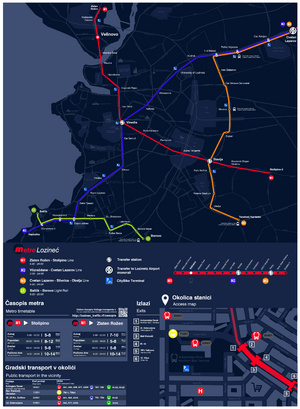
The current map of the Lozinetz was designed in 2017 by students from the Faculty of Urbanism of the University of Lozinetz

Navigation sign at Station Velinovo
See also


