Port-aux-Perdrix
Port-aux-Perdrix
Port Partridge | |
|---|---|
Village | |
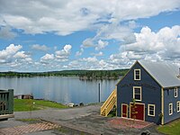 Port-aux-Perdrix Harbour | |
| Motto(s): Nous endurerons English: We will endure | |
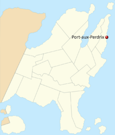 Port-aux-Perdrix's location in Iylan Province. | |
| Country | Rhodevus |
| Province | Iylan Province |
| County | Hauteterre |
| Incorporated | 1873 |
| Founded by | Jean-Baptise Chiasson |
| Electoral District | Hauteterre—Lijlan-d'Est |
| Government | |
| • Type | County Council |
| • Body | Conseil du comté Hauteterre |
| • Warden | Rhéal Caron (Parti Conservateur d'Iylan) |
| Area | |
| • Total | 8.2 km2 (3.2 sq mi) |
| Elevation | 3 m (10 ft) |
| Population (2015) | |
| • Total | 639 |
| • Density | 78/km2 (200/sq mi) |
Port-aux-Perdrix (/ˌpɔɹt oʊ ˈpɛəɹdɹiː/, French: /ˌpɔʁ o pɛʁˈdʁi/) is a unincorporated community located in Hauteterre county, Iylan Province, Rhodevus. It is situated on the southern shore of Partridge Bay (Baie du Perdrix), an inlet of the Lutetian Ocean on the eastern coast of the Saint-Jean peninsula. Port-aux-Perdrix was founded in 1873 by French-speaking settlers, who named it for the abundance of partridges living in the forests around the bay. After reaching a peak population of 2,076 in 1925, Port-aux-Perdrix's population fell gradually, counting 639 residents in 2015.
The village lies in the Francophone areas of Rhodevus, and a large majority of its inhabitants count French as their mother tongue. Port-aux-Perdrix relies heavily on fishing as a source of income and is the main employer in the community, though the population continues to decrease along with economic output, accelerated by the opening of a cannery in Baie St.-Paul, twelve kilometres southeast, pulling more jobs away from the community. Port-aux-Perdrix, along with many other rural communities in Rhodevus, is beginning to rely on higher levels of government for assistance as the viability of subsiding off fishing alone decreases.
History
The area Port-aux-Perdrix occupies today has been known and explored for thousands of years by indigenous peoples, primarily the Ghong, who called it iqalukkuit, meaning "rivers of fish". The first explorers are believed to have come in the early 16th century, with the first definitive account of the area recorded in 1568 by Georges Éupéry de Montblanc. It is inferred that no indigenous settlements existed on the bay at this time, or rather that they were seasonal, as the main inhabited regions were south past Cap Sainte-Marie, and de Montblanc makes no mention of any encounter in his daybook.
Nous traversâmes aujourd'hui un point, je présume le Cap Sainte-Marie, à travers lequel y était une baie d'eau dans en terre boisée. Lors de l'entrée des eaux dociles, on voyait plusieurs gibiers à plumes. Nous montrerons notre camp ici ce soir- il y a sûrement un abondance de nourriture dans les eaux et à terre.
We rounded today a point, I presume to be the Cap Sainte-Marie, across which lay a bay of water in a forested land. Upon entering the calm waters, many gamebirds were seen. We make our camp here tonight; there is surely plentiful food to be found in the waters and in the land.— Un racont des voyages au Nord et la vie de Georges Éupéry de Montblanc (1575)
First Settlements
Although first discovered in 1568, the bay was not settled until the early 1740s, when fishermen looking for less crowded land on which to live moved northwards, mainly from the larger city of Acadia. The first families to occupy the area were the Caron, Blanchet, and Chiasson families. As the settlement's population grew, the decision was made to fortify the community, beginning with a wooden rampart in 1755, providing a safe haven for small ships in the northern parts of Rhodevus, which proved to be important in the unrest that followed over the next century.
Jean-Baptiste Chiasson, a minister from Baie St.-Paul, established the church of Notre-Dame-la-sauveuse-du-peuple-en-Port-aux-Perdrix in 1869, taking the name for the church from the bay described by de Montblanc three centuries earlier. The church became the focal point of the sprouting fishing community, and an attractive draw for new settlers, with more than 30 families arriving in the next decade. The village was incorporated as a town on December 3, 1873, one of the first towns incorporated in Hauteterre County.
Raid on Icaloucouit
On the evening of August 4, 1742, the Ghong tribe local to the area raided the burgeoning settlement, which at that time counted 80 people, 50 of whom were fishermen, vital to the community. The raiders took 3 men hostage, and killed 2 more before retreating to their own settlement. Today, a plaque acknowledges the event on the outskirts of the community, though while the raid was once seen as an example of native aggression towards settlers, it is now being recognized as a symptom of a larger system of repression in which the indigenous peoples gradually lost rights, land and possessions to the new settlers, and where resistance was brutally punished.
The governor of the contemporaneous northern territories recounts in a daybook:
[...] il y eut un terrible assaut directé vers une colonie dessous mon contrôle il y a une quinzaine. Des quatre-vingt colons, trois seraient tués, et deux ne retourneraient jamais, prises par les agresseurs. Un véritable désastre.
... there had been a terrible attack on one settlement under my control, a fortnight ago. Of the eighty settlers, three would be killed, and two more would never return. A true disaster.— François Royer, Gouverneur des Territoires septentrionaux provisionnels (1742)
The Rhodeve Empire
The people in Port-aux-Perdrix did not learn of the events that took place in 1754, where Emilia Hart gained power and transformed Rhodevus into an empire, until nearly 3 years after the events had taken place. By this time, Rhodevus had begun engaging in naval warfare across Sunalaya, and international trade became much more lucrative. Goods in Rhodevus became cheaper and more affordable for the people in Port-aux-Perdrix, which led to a higher quality of life and a population increase in the years thereafter.
The Rhodeve Collapse
Main article: The Rhodeve Collapse
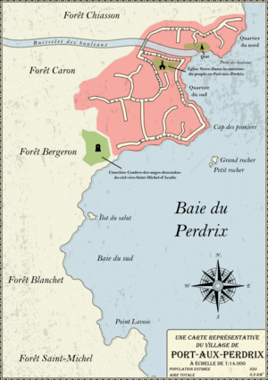
Port-aux-Perdrix is furthermore known as the final resting place of two naval military commanders, Wulffe Lindholm from Talvistova and Wülfric von Edelhols from the Düotinnari Kingdom, renowned for their skills during the Rhodeve Collapse of 1840 to 1845. They are buried in the Cendres-des-anges-descendus-du-ciel-vers-Saint-Michel-d'Acadie cemetery on the southern extent of the community, the main cemetery associated with the Notre-Dame-la-sauveuse-du-peuple-en-Port-aux-Perdrix church. Although now famous partly because of the collapse and the famous burials, Port-aux-Perdrix was largely unaffected by the conflict, counting only an estimated 100 to 120 people during that time period. Notably, a farmer from the outskirts of Rome, Herbert Lemaître, was the first to bring hardier crops north to Port-aux-Perdrix, allowing the cultivation of wheat and rye in the short summers, leading to a more stable and varied food supply. Descendants of Lemaître still run the original farm about two kilometres north of the village centre.
1920s Boom Town, the World Wars and the Great Depression
During both world wars, Port-aux-Perdrix was hit hard by food and supply rationing. Prices increased exponentially for household items, making everyday life less affordable. In a sense, the Great Depression never ended in Rhodeve fishing towns as it had for the rest of the country. The aid given by the government in the 1930s simply was not adequate to regulate prices. Fish prices stayed low as the market was over-saturated, a trend that began in the 1920s and continued through the following two decades. Prices for other goods such as manufactured items and refined foods stayed high, as the demand was higher than the smaller workforce could provide.
In contrast, the 1920s is considered the heyday of Port-aux-Perdrix and the fishing industry. The international economy was strong, and products could be exported all over the globe, despite the over-saturation of the domestic market. Fishing became more lucrative than ever, and more people could afford items previously considered luxuries, like oranges from tropical regions or fresh apples in the winter. Industrial companies began to capitalize on the leftover fish that could not be sold by canning it and shipping it out across the globe, providing a source of employment for the coastal towns. For the first time in its history, the employment rate in Port-aux-Perdrix hit nearly one hundred percent, peaking at 99.1% in early 1928. As the world markets became saturated with manufactured goods, however, prices steadily dropped, and by September 1929 the world economy was in freefall, culminating in the largest stock market crash in history.
All but one of the canning plants near Port-aux-Perdrix closed between 1930 and 1933, putting nearly a thousand people out of work. They soon went back to fishing as they had previously, but the prices were not suitable for sustainable fishing in the long-term, and more fish needed to be sold in order to survive. This led to the first depopulation of fish in the bay, where a sharp drop in both numbers and diversity affected the local ecosystems, and put many out of work again. By the time of the arrival of the government's unemployment insurance in 1934, the unemployment rate in Port-aux-Perdrix had hit nearly 40%. Both the fish stocks and the local economy would never recover until the early 2000s. In 1935, after losing a quarter of its population in the last decade, Port-aux-Perdrix was unincorporated and made a community, governed directly from Kikitamouk, the seat of the county.
The depression continued along the coast until the end of the Second World War, but the conflict had no real effect on the community until conscription was introduced in 1943. Of the nearly 1200 residents, 12 went to fight for the Rhodeve army, one of whom, Bernard Gâchon, was famous for using his whaling harpoon in the field of battle. Of the twelve who fought during the war, only 6 came back to the community afterwards, including Bernard Gâchon, who was killed on the 6th of November, 1944.
Slow Decline
Since 1945, the community has been decreasing in population, mainly due to emigration, especially to other areas of Rhodevus, in search of a job. Since 1920, the population of the village has been more than halved, from a peak in 1929 of more than two thousand, to fewer than seven hundred residents in 2015. The economy of the area has tried to diversify without much success, although the government now runs a tourist program that covers all of the eastern coast of Iylan province, contributing to a recent foray by the county into a cottage resort near the community. The decline in the population of the village has been accelerated by the opening of a cannery in nearby Baie St.-Paul, which, being reasonably close to the community, is an economic factor drawing residents away. The former warden of the county, Gilles de Rochambeau, grew up in Port-aux-Perdrix but left for Kikitamouk once having been elected and never returned.
The citizens of the community have been requesting help from the government to help them survive ever since the moratorium on fishing in 1998, which devastated the town. Fish stocks remain low, but the allowances are strict and not enough to survive. The community has requested aid in opening a factory, of any kind, near the village so that their way of life can persist. The government has been reluctant to offer any aid, presenting instead the idea that they may need to be relocated in order to subsist. The warden of the county has also presented the idea of petitioning international governments for aid in finding a company interested in opening a factory near them.
Geography
Port-aux-Perdrix lies at the point where the Ruisselet des Bouleaux meets the Baie du Perdrix, in the northwestern corner of the bay. The original settlement founded by Montblanc is estimated to lie further south in the bay, though no trace remains. Baie du Perdrix is mostly shallow, but had a channel dredged in the 1920s to accommodate larger vessels. The community lies on the eastern shore of the Saint Jean peninsula, the most remote maritime region of northern Rhodevus. Originally, the area was inhabited by indigenous peoples, primarily the Ghong, however since the complete colonization of Rhodevus, the majority of indigenous peoples in northern Rhodevus have been placed in reservations, Iylan province being no exception. Fifty-two kilometres to the west of Port-aux-Perdrix lies the Ghong reservation of Akiani, with a population of ninety-two. The reservation is governed directly from the federal level, however the community is considered neglected by the federal government and has lobbied for aid from other levels of government, as is the typical situation in many reservations in Rhodevus. North of the reservation is a the Akuliaq National Park and Wildlife Reserve, which occupies a large space of the mountains in the interior of the Saint Jean peninsula.
Though the lands to the west and north of Port-aux-Perdrix are mountainous and mostly barren, Port-aux-Perdrix lies in a subtle valley developed by the Ruisselet des Bouleaux. The forest cover around the village is a mix of coniferous and deciduous, whereas inland it is overwhelmingly coniferous, due to the milder temperatures and more developed soils around the bay. Around twelve thousand years ago, when the vast majority of Rhodevus was covered under ice sheets and glaciers, a proglacial river flowed out near where Port-aux-Perdrix lies today, out to the sea an estimated further twenty kilometres, as the sea levels were much lower. The soils deposited by this river were the top layers of soil stripped from other regions by the glacier, and contribute to the favourable soil conditions around Port-aux-Perdrix. Some deposits in the ancient riverbed match the composition of some soils nearly three hundred kilometres to the north.
Geology
The geological features underlying Port-aux-Perdrix are largely consistent with the geologic province in which it is located, the Rhodeve shield. The bedrock underneath most of Port-aux-Perdrix is made up of acidic intrusive igneous rock, consistent with the granitic formations of the Rhodeve shield. The granitic formations are partially overlain with an intermediate intrusive igneous formation, resembling the diorite found further north in the Saint-Jean peninsula, thought to have been partially carried southwards by the movement of glaciers during the ice ages. The igneous formations in this area are considered to be some of the oldest in the world, tentatively dated to around three and a half billion years ago. To the south of Port-aux-Perdrix is a formation of high and medium grade metamorphic rocks, mostly marble, gneiss and schist. This is consistent with the formation of the Lijlan mountain range that makes up the eastern Saint-Jean peninsula, part of the eastern maritime orogeny that occured around five hundred million years ago when the Lutetian plate subducted underneath the North Corentian plate. In addition, the proglacial river that flowed for almost twenty thousand years into the Lutetian ocean, now represented by the Ruisselet des Bouleaux, laid down several layers of sedimentary stone of varying particle sizes, including sandstone, siltstones, shales and mudstones.
Pedology
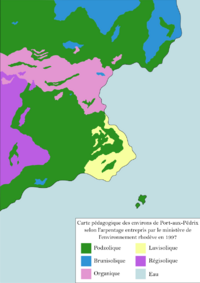
The soils of Port-aux-Perdrix are surprisingly varied for a previously glaciated area, as much of the topsoil should have been stripped away by the gouging force of the advancing ice. However, the proglacial river that flowed out into the bay carried sediment from a variety of regions into its delta, depositing them in an alluvial fan. Further into the Lutetian ocean, a terminal moraine of the ice sheet can be found. Soil around the Cap des pioniers is luvisolic, evidence of sedimentary deposits upriver now destroyed by the glaciation, and stabilized in their current location by the tamarack trees that thrive in the more basic conditions.
Brunisolic soils found immediately north of the village are also evidence of sedimentary bedrock now erased by glaciation and are thought to originate somewhere far west of the Saint Jean peninsula, possibly somewhere that is now underwater. Brunisolic soils are conducive to both deciduous and coniferous forest cover, and harbour some of the most northerly deciduous forests in the world. However, the vast majority of soil in Port-aux-Perdrix is of the podzolic type, and is presumed to have developed very recently. The podzolic soils are very thin and populated almost exclusively by coniferous species, and as a consequence are very acidic. Podzolic soils have a tendency to leach iron and clay from water, making them very poor for farming.
Additionally, regosolic soils can be found in and around the Lijlan mountains, as the slopes of the mountains are unstable and not conducive to deeper soil formation, where rainwaters wash most of the accumulated sediment down into river valleys. The creek flowing into the Baie du Perdrix is somewhat stable, and therefore no regosolic soils form in the floodplain. Instead, organic soils made up mainly of decaying river plant matter fill the areas in and around the river. The organic soil of the riverbed is somewhat acidic and boggy, making for poor quality farming conditions near the river. Therefore, the only soils especially suited to farming are located mostly north of Port-aux-Perdrix and not in the village centre.
Climate
Port-aux-Perdrix has a subarctic climate, belonging to the Köppen Dfc subtype. The variations during a year can be divided into four distinct seasons, although spring and autumn may be considerably shorter than summer and winter. The average July maximum temperature is 12.4°C (54.3°F), and the average January minimum temperature is -19.8°C (-3.6°F).
Summers are mild and relatively humid for the region, affected by the moderating effect of the ocean. The average high reaches above 10 degrees Celsius in only two months, July and August. On average, 11 days a year have temperatures above 20 degrees Celsius, though the record highs have reached much higher. If the humidex is considered, 37 days a year have temperatures above 20 degrees.
Snow and ice dominate the winter season, with very little rain falling as temperatures rarely reach above the freezing point. On average, Port-aux-Perdrix receives 47 centimetres of snow a year, and retains nearly 30 centimetres of snowpack throughout the winter season. 36 days of the winter months experience lows below -30 degrees Celsius, or 51 days if the wind chill is considered.
Spring and fall are short and variable, prone to temperature extremes and unpredictable swings in both precipitation amounts and temperatures. Days above 15 degrees have occurred as early as April and as late as September. Annual precipitation averages around 950 millimetres.
| Climate data for Port-aux-Perdrix, 1985-2010 normals and extremes | |||||||||||||
|---|---|---|---|---|---|---|---|---|---|---|---|---|---|
| Month | Jan | Feb | Mar | Apr | May | Jun | Jul | Aug | Sep | Oct | Nov | Dec | Year |
| Record high Humidex | 8.7 | 7.8 | 9.8 | 16.6 | 24.3 | 31.3 | 32.5 | 29.5 | 26.4 | 16.6 | 10.0 | 4.5 | 32.5 |
| Record high °C (°F) | 5.6 (42.1) |
6.1 (43.0) |
8.2 (46.8) |
15.0 (59.0) |
17.4 (63.3) |
18.9 (66.0) |
24.7 (76.5) |
25.2 (77.4) |
19.1 (66.4) |
11.2 (52.2) |
8.1 (46.6) |
6.1 (43.0) |
25.2 (77.4) |
| Average high °C (°F) | −8.1 (17.4) |
−8.6 (16.5) |
−5.3 (22.5) |
−2.3 (27.9) |
5.2 (41.4) |
9.6 (49.3) |
12.4 (54.3) |
11.7 (53.1) |
9.5 (49.1) |
5.0 (41.0) |
−0.2 (31.6) |
−3.4 (25.9) |
2.1 (35.8) |
| Daily mean °C (°F) | −12.2 (10.0) |
−13.1 (8.4) |
−9.1 (15.6) |
−5.8 (21.6) |
−0.7 (30.7) |
4.9 (40.8) |
6.7 (44.1) |
6.2 (43.2) |
4.2 (39.6) |
2.5 (36.5) |
−3.6 (25.5) |
−5.7 (21.7) |
−2.1 (28.2) |
| Average low °C (°F) | −19.8 (−3.6) |
−21.6 (−6.9) |
−15.1 (4.8) |
−5.2 (22.6) |
−2.6 (27.3) |
−0.2 (31.6) |
2.1 (35.8) |
3.2 (37.8) |
3.1 (37.6) |
−2.4 (27.7) |
−5.2 (22.6) |
−14.2 (6.4) |
−6.5 (20.3) |
| Record low °C (°F) | −39.4 (−38.9) |
−40.1 (−40.2) |
−36.2 (−33.2) |
−32.7 (−26.9) |
−17.5 (0.5) |
−6.7 (19.9) |
−7.1 (19.2) |
−5.2 (22.6) |
−13.8 (7.2) |
−17.1 (1.2) |
−19.3 (−2.7) |
−24.8 (−12.6) |
−40.1 (−40.2) |
| Record low wind chill | −52.9 | −59.5 | −54.0 | −41.3 | −20.8 | −10.1 | −5.0 | −3.4 | −9.1 | −31.2 | −33.3 | −55.5 | −59.5 |
| Average precipitation mm (inches) | 83.8 (3.30) |
70.9 (2.79) |
73.6 (2.90) |
71.1 (2.80) |
57.0 (2.24) |
83.4 (3.28) |
98.6 (3.88) |
71.5 (2.81) |
81.9 (3.22) |
74.2 (2.92) |
77.6 (3.06) |
81.9 (3.22) |
919.5 (36.20) |
| Average rainfall mm (inches) | 3.1 (0.12) |
5.1 (0.20) |
5.5 (0.22) |
14.1 (0.56) |
30.2 (1.19) |
70.1 (2.76) |
98.6 (3.88) |
71.5 (2.81) |
79.9 (3.15) |
49.7 (1.96) |
14.1 (0.56) |
8.4 (0.33) |
450.3 (17.74) |
| Average snowfall cm (inches) | 80.9 (31.9) |
65.9 (25.9) |
68.2 (26.9) |
56.9 (22.4) |
26.7 (10.5) |
13.3 (5.2) |
0.0 (0.0) |
0.0 (0.0) |
2.0 (0.8) |
24.5 (9.6) |
63.5 (25.0) |
73.4 (28.9) |
475.3 (187.1) |
| Average precipitation days (≥ 0.2 mm) | 14.1 | 12.0 | 13.1 | 13.7 | 13.0 | 15.0 | 16.0 | 15.4 | 15.3 | 14.6 | 13.8 | 14.1 | 170.1 |
| Average rainy days (≥ 0.2 mm) | 1.0 | 1.0 | 1.6 | 3.4 | 8.3 | 14.2 | 16.2 | 15.4 | 15.2 | 10.1 | 3.1 | 1.8 | 91.3 |
| Average snowy days (≥ 0.2 cm) | 13.9 | 11.7 | 12.8 | 12.2 | 7.7 | 2.9 | 0.0 | 0.0 | 0.8 | 7.4 | 12.6 | 13.3 | 95.3 |
| Average relative humidity (%) | 54.4 | 56.7 | 64.3 | 74.4 | 75.1 | 77.7 | 76.5 | 71.2 | 65.3 | 60.9 | 55.5 | 55.1 | 65.6 |
| Mean monthly sunshine hours | 99.3 | 131.3 | 167.1 | 189.8 | 229.8 | 254.2 | 279.0 | 249.3 | 177.6 | 139.4 | 84.3 | 82.6 | 2,083.7 |
| Percent possible sunshine | 35.0 | 44.9 | 45.3 | 46.9 | 49.9 | 54.3 | 58.9 | 57.1 | 47.1 | 41.0 | 29.4 | 30.3 | 45.0 |
| Source: Département national rhodève de la météorologie | |||||||||||||
Demographics
| Historic Population | ||
|---|---|---|
| Year | Pop. | ±% |
| 1880 | 421 | — |
| 1890 | 503 | +19.5% |
| 1900 | 623 | +23.9% |
| 1910 | 850 | +36.4% |
| 1920 | 1,271 | +49.5% |
| 1925 | 2,076 | +63.3% |
| 1930 | 1,854 | −10.7% |
| 1935 | 1,543 | −16.8% |
| 1940 | 1,186 | −23.1% |
| 1945 | 1,153 | −2.8% |
| 1950 | 1,103 | −4.3% |
| 1955 | 1,082 | −1.9% |
| 1960 | 1,074 | −0.7% |
| 1965 | 1,042 | −3.0% |
| 1970 | 1,003 | −3.7% |
| 1975 | 994 | −0.9% |
| 1980 | 974 | −2.0% |
| 1985 | 901 | −7.5% |
| 1990 | 900 | −0.1% |
| 1995 | 903 | +0.3% |
| 2000 | 854 | −5.4% |
| 2005 | 819 | −4.1% |
| 2010 | 753 | −8.1% |
| 2010 | 692 | −8.1% |
| 2015 | 639 | −7.7% |
Religion in Port-aux-Perdrix (2015)
In 2015, the population of Port-aux-Perdrix was 639, with a population density of 78/km2 through the village's 8.2 square kilometres. Port-aux-Perdrix is the 28th largest community in Hauteterre County and the 1077th largest community in Iylan Province. The median age of Port-aux-Perdrix's population is 61.8, well above the provincial and national averages. People aged 15 and under make up 13% of the population, while people aged 65 and over make up 23%.
Approximately 78% of residents in Port-aux-Perdrix identified as Catholic in 2010, with a further 11% identifying with another form of Christianity and 1% of residents affiliated with Islam. Just over 9% of residents identified with no religion or as irreligious. Religion in Port-aux-Perdrix strongly correlates with ethnic background. 98% of residents identified as Rhodeve, while 2% were of a minority ethnicity, mostly of Ghong native ancestry. 97% of residents chose French as their mother tongue, 2% Ghong and 1% English.
Fewer than a third of residents had graduated from a post-secondary institution in 2015, continuing a trend found throughout rural Iylan province. In addition, only a little over half had graduated from secondary education, marking one of the lowest rates for a community in Hauteterre county. Along with lower rates of higher education, Port-aux-Perdrix has an unemployment rate of nearly 23 percent, mainly due to a collapse of the fishing industry in the area. A majority of residents in Port-aux-Perdrix identified that they rely at least partially on government assistance to remain financially stable. The median annual income in 2015 was 33 450 Rhodes, a decrease of nearly 5 percent from the previous census.
