File:RUS-2016-Aerial-SPB-Krestovsky Stadium 01.jpg
Jump to navigation
Jump to search


Size of this preview: 800 × 533 pixels. Other resolutions: 320 × 213 pixels | 640 × 427 pixels | 1,024 × 683 pixels | 1,280 × 853 pixels | 2,560 × 1,707 pixels | 7,188 × 4,792 pixels.
Original file (7,188 × 4,792 pixels, file size: 13.92 MB, MIME type: image/jpeg)
Summary
| Description |
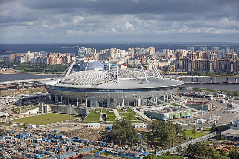
Polski: Stadion Kriestowskij, nazywany też Zenit Arena, położony na Wyspie Kriestowskiej w Petersburgu, w Rosji.
Македонски: Стадионот „Санкт Петербург“ во истоимениот град во Русија.
|
| Date | |
| Source | Own work |
| Author | Godot13 |
| Other versions |
 |
| Attribution (required by the license) | Andrew Shiva / Wikipedia / |
| Camera location | | View this and other nearby images on: OpenStreetMap |
|---|
Assessment
|
This image was selected as picture of the day on Wikimedia Commons for 14 June 2018. It was captioned as follows: Other languages:
Polski: Stadion Kriestowskij, nazywany też Zenit Arena, położony na Wyspie Kriestowskiej w Petersburgu, w Rosji. Македонски: Стадионот „Санкт Петербург“ во истоимениот град во Русија. |

|
This image has been assessed under the valued image criteria and is considered the most valued image on Commons within the scope: Krestovsky Stadium, view from sw. You can see its nomination here. |
This image was selected as picture of the day on Bengali Wikipedia.
|
Licensing
I, the copyright holder of this work, hereby publish it under the following license:
This file is licensed under the Creative Commons Attribution-Share Alike 4.0 International license.
- You are free:
- to share – to copy, distribute and transmit the work
- to remix – to adapt the work
- Under the following conditions:
- attribution – You must give appropriate credit, provide a link to the license, and indicate if changes were made. You may do so in any reasonable manner, but not in any way that suggests the licensor endorses you or your use.
- share alike – If you remix, transform, or build upon the material, you must distribute your contributions under the same or compatible license as the original.
|
According to article 1276 of the Civil Code of Russia in the amendment of October 1, 2014, it shall be allowed to reproduce "works of architecture, of urban development, and of garden and landscape design" for any purpose and without consent of the copyright holder(s), provided that these works are "situated in places open for free attendance, or visible from such places". Note that for any other kind of artwork, even if permanently situated in public place (for example, statues and monuments), this exception is still limited to non-commercial usage which is not compatible with Commons:Licensing. For details, see COM:CRT/Russia#Freedom of panorama.
|

|
The copyright holder of this file, Andrew Shiva, allows anyone to use it for any purpose, provided that the copyright holder is properly attributed. Redistribution, derivative work, commercial use, and all other use is permitted. |
Attribution:
Use or reproduction of this image outside of Wikipedia must give the original photographer (Andrew Shiva) credit. Although not required, it would be appreciated if a message was left here indicating where this image was being used.
|
File history
Click on a date/time to view the file as it appeared at that time.
| Date/Time | Thumbnail | Dimensions | User | Comment | |
|---|---|---|---|---|---|
| current | 18:44, 30 September 2016 | | 7,188 × 4,792 (13.92 MB) | wikimediacommons>Godot13 | highlights/shadows |
File usage
The following page uses this file: