Scheduled Maintenance
The wiki will be going down for routine maintenance on Wednesday, July 17th, 2024, at approximately 1:00 PM Central Time (13:00) or 11:00 Pacific Time. The site may be inaccessible during this time and the database will be locked from editing. We expect the maintenance to take about one hour. We strongly encourage joining our Discord for updates.
File:Surisjardinar map.png
Jump to navigation
Jump to search

No higher resolution available.
Surisjardinar_map.png (399 × 175 pixels, file size: 15 KB, MIME type: image/png)
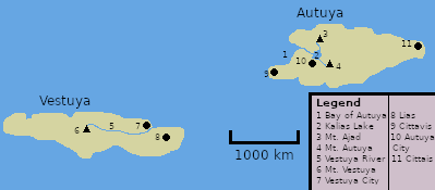
Summary
Map of Surisjardinar.
File history
Click on a date/time to view the file as it appeared at that time.
| Date/Time | Thumbnail | Dimensions | User | Comment | |
|---|---|---|---|---|---|
| current | 01:27, 31 May 2023 | | 399 × 175 (15 KB) | The Ice States (talk | contribs) | Map of Surisjardinar. |
You cannot overwrite this file.
File usage
The following page uses this file: