File:מתחם אַוּגוּסְטֶה ויקטוֹריה.jpg
Jump to navigation
Jump to search


Size of this preview: 800 × 449 pixels. Other resolutions: 320 × 180 pixels | 640 × 360 pixels | 1,024 × 575 pixels | 1,280 × 719 pixels | 2,560 × 1,438 pixels | 4,329 × 2,432 pixels.
Original file (4,329 × 2,432 pixels, file size: 2.13 MB, MIME type: image/jpeg)
Summary
| Description |
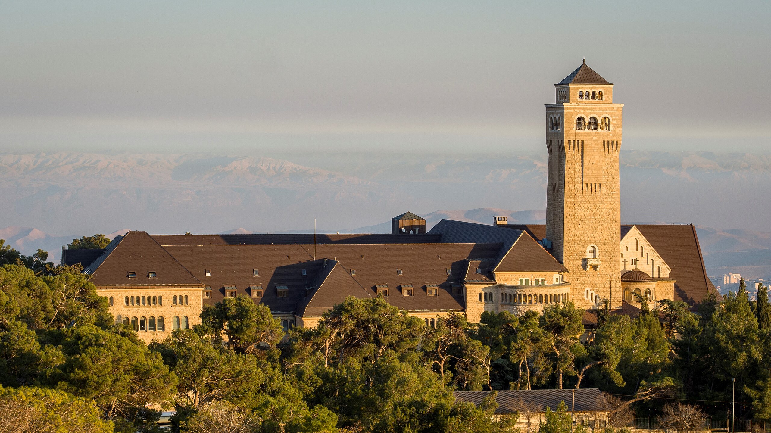
עברית: מתחם אַוּגוּסְטֶה ויקטוֹריה משתרע על שטח של כ-80 דונם בפסגת הר הזיתים בירושלים. נקרא על שם אוגוסטה ויקטוריה משלזוויג הולשטיין, אשתו של מקים המתחם, וילהלם השני, קיסר גרמניה. במתחם כנסייה עם מגדל פעמונים, וכן אכסניית צליינים. כיום משמש כבית חולים, ובמזרחו ממוקם "המכון הגרמני הפרוטסטנטי לארכאולוגיה בארץ הקודש".
Deutsch: Auguste-Viktoria-Hospital ist ein Kirchen- und Krankenhaus-Komplex an der Nordseite des Ölbergs in Ostjerusalem.
English: Auguste Victoria Compound is a church-hospital complex located on the northern side of Mount of Olives in East Jerusalem.
Español: Hospital Augusta Victoria es un complejo que incluye una iglesia y un hospital situado en el norte del Monte de los Olivos, Jerusalén Este.
Українська: Комплекс «Августа Вікторія» — церковно-лікарняний комплекс, названий на честь Августи Вікторії, розташований на північній стороні Оливкової гори в Східному Єрусалимі. |
||
| Date | |||
| Source | Own work | ||
| Author | אורי אלוני |
| Camera location | | View this and other nearby images on: OpenStreetMap |
|---|
צילום אוויר מרחפן
Licensing
I, the copyright holder of this work, hereby publish it under the following license:
This file is licensed under the Creative Commons Attribution-Share Alike 4.0 International license.
- You are free:
- to share – to copy, distribute and transmit the work
- to remix – to adapt the work
- Under the following conditions:
- attribution – You must give appropriate credit, provide a link to the license, and indicate if changes were made. You may do so in any reasonable manner, but not in any way that suggests the licensor endorses you or your use.
- share alike – If you remix, transform, or build upon the material, you must distribute your contributions under the same or compatible license as the original.
Assessment
|
This image was selected as picture of the day on Wikimedia Commons for 3 April 2023. It was captioned as follows: English: Auguste Victoria Compound is a church-hospital complex located on the northern side of Mount of Olives in East Jerusalem. Other languages:
Čeština: Nemocnice Auguste Victoria je izraelský církevní komplex na severní straně Olivové hory ve Východním Jeruzalému. Deutsch: Das Auguste-Viktoria-Hospital ist ein Kirchen- und Krankenhaus-Komplex an der Nordseite des Ölbergs in Ostjerusalem. English: Auguste Victoria Compound is a church-hospital complex located on the northern side of Mount of Olives in East Jerusalem. Español: Hospital Augusta Victoria es un complejo que incluye una iglesia y un hospital situado en el norte del Monte de los Olivos, Jerusalén Este. Français : L'hôpital Augusta Victoria, hôpital de Jérusalem (Israël) qui contient l'église protestante allemande de l'Ascension, dont le clocher de 50 mètres, qui surmonte le mont des Oliviers, est un point de repère de la ville. Magyar: Az Auguszta Viktória Kórház, egy templomkórház-komplexum Kelet-Jeruzsálemben, az Olajfák hegyének északi oldalán Português: Complexo Augusta Vitória é um edifício de igreja-hospital localizado no lado norte do Monte das Oliveiras, em Jerusalém Oriental. Slovenščina: Auguste Victoria Compound je kompleks cerkve in bolnišnice na severni strani Oljske gore v Vzhodnem Jeruzalemu. Македонски: Германската лутеранска болница и црква „Августа Викторија“ на Маслиновата Гора во Источен Ерусалим. Українська: Комплекс «Августа Вікторія» — церковно-лікарняний комплекс, розташований на північній стороні Оливкової гори в Східному Єрусалимі. |
This image has been assessed using the Quality image guidelines and is considered a Quality image.
|

|
This image was uploaded as part of Wiki Loves Monuments 2016.
|
 |
File history
Click on a date/time to view the file as it appeared at that time.
| Date/Time | Thumbnail | Dimensions | User | Comment | |
|---|---|---|---|---|---|
| current | 07:10, 1 April 2020 | | 4,329 × 2,432 (2.13 MB) | wikimediacommons>Andrew J.Kurbiko | fix |
File usage
The following page uses this file: