Ruthish Demilitarized Zone
This article is incomplete because it is pending further input from participants, or it is a work-in-progress by one author. Please comment on this article's talk page to share your input, comments and questions. Note: To contribute to this article, you may need to seek help from the author(s) of this page. |
| Ruthish Demilitarized Zone | |
|---|---|
Ruthische Entmilitarisierte Zone | |
| Ruthen | |
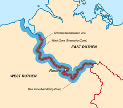
 The Ruthish DMZ is indicated by the Black Zone (grey) and the Blue Zone (blue); the Armistice Demarcation Line serving as the international boundary is shown in red. | |
| Type | Demilitarized zone |
| Length | 290 km (180 mi) |
| Site information | |
| Open to the public | Access granted by UCMAR for the Blue Zone; access universally denied for the Black Zone |
| Condition | Fully manned and operational |
| Site history | |
| Built by | |
| In use | Since 4 August 1999 (25 years ago) |
| Events | Six-Day War (Division of Ruthen) 2024 Hunsrück crisis (Ruthish conflict) |
The Ruthish Demilitarized Zone (DMZ or EMZ; Ruthish: Ruthische Entmilitarisierte Zone) is a demilitarized zone and border barrier that divides Ruthen. Serving as a buffer zone between West Ruthen and East Ruthen following the Six-Day War, it was established under the auspices of the United Congress by the Ruthish Armistice Agreement on 4 August 1999. The United Congress Monitoring Authority for Ruthen (UCMAR) patrols and monitors the DMZ as an interim peacekeeping force.
The DMZ is approximately 290 km (180 mi) long and about 26 km (16 mi) wide at its widest point. It is primarily composed of two distinct zones: the Black Zone (Schwarze Zone) is about 9.6 km (6 mi) wide and perpetually evacuated of civilian populations and military presence; the Blue Zone (Blaue Zone) is in excess of 16 km (10 mi) wide and requires permissions to enter and inhabit; the Armistice Demarcation Line (Demarkationslinie) inside both zones denotes the international border between the two countries. All former cities and former settlements which lie inside the Black Zone are abandoned, the largest of which being Rosche on the West Ruthish side.
The dormant UCMAR force was reactivated following the 2024 Hunsrück crisis, which took place inside the DMZ.