Diagbon: Difference between revisions
No edit summary |
|||
| Line 49: | Line 49: | ||
'''Diagbon''', officially the Republic of Diagbon, is a country located along the {{wp|Gulf of Guinea}} and {{wp|Atlantic Ocean}}, in the sub region of {{wp|West Africa}}. Spanning a land mass of 408,256 km<sup>2</sup> (157,629 sq. mi), Diagbon is bordered by French speaking countries to the west, north and east; and the Gulf of Guinea and Atlantic Ocean in the south. The country's official language of government and business is English. Roughly 90% of the population speaks one of three widely spoken native languages: Siafo, Maale, and Bwaa. Formerly called the [[Republic of Volta]] (1959–1961), the country was renamed "Diagbon" on 10 June 1961 by erstwhile President [[Thomas Hayes Sangoule]]. Its citizens are known as Diagbonese. Its capital is Compaore. Diagbon’s population of approximately 65 million spans a variety of ethnic, linguistic and religious groups. According to the 2015 census, 77% of the population was Christian, 17% was Muslim, and 5% practiced traditional faiths. Its diverse geography and ecology ranges from coastal savannas to tropical rain forests. | '''Diagbon''', officially the ''Republic of Diagbon'', is a country located along the {{wp|Gulf of Guinea}} and {{wp|Atlantic Ocean}}, in the sub region of {{wp|West Africa}}. Spanning a land mass of 408,256 km<sup>2</sup> (157,629 sq. mi), Diagbon is bordered by French speaking countries to the west, north and east; and the Gulf of Guinea and Atlantic Ocean in the south. The country's official language of government and business is English. Roughly 90% of the population speaks one of three widely spoken native languages: Siafo, Maale, and Bwaa. Formerly called the [[Republic of Volta]] (1959–1961), the country was renamed "Diagbon" on 10 June 1961 by erstwhile President [[Thomas Hayes Sangoule]]. Its citizens are known as Diagbonese. Its capital is Compaore. Diagbon’s population of approximately 65 million spans a variety of ethnic, linguistic and religious groups. According to the 2015 census, 77% of the population was Christian, 17% was Muslim, and 5% practiced traditional faiths. Its diverse geography and ecology ranges from coastal savannas to tropical rain forests. | ||
The first permanent state in the territory of present-day Diagbon dates back to the 8<sup>th</sup> century. Numerous kingdoms and empires emerged over the centuries, of which the most powerful was the Da-Maale [[ | The first permanent state in the territory of present-day Diagbon dates back to the 8<sup>th</sup> century. Numerous kingdoms and empires emerged over the centuries, of which the most powerful was the Da-Maale [[kingdom of Yameogo]] and the Mamprudu [[kingdom of Ahantana]]. Beginning in the 15th century, the Portuguese Empire, followed by numerous other European powers, contested the area for trading rights, until the British ultimately established control of the coast by the late 19th century. Following over a century of native resistance, Diagbon’s current borders were established by the 1900s as the [[British Volta Colony|British Volta]]. It became independent from the United Kingdom on 1 October 1959. | ||
Diagbon is a unitary constitutional democracy led by a president who is both head of state and head of the government. Diagbon‘s growing economic prosperity and democratic political system have made it a regional power in West Africa. It is a member of the {{wp|Non-Aligned Movement}}, the {{wp|African Union}}, the {{wp|Economic Community of West African States}} (ECOWAS), and the {{wp|Commonwealth of Nations}} | Diagbon is a unitary constitutional democracy led by a president who is both head of state and head of the government. Diagbon‘s growing economic prosperity and democratic political system have made it a regional power in West Africa. It is a member of the {{wp|Non-Aligned Movement}}, the {{wp|African Union}}, the {{wp|Economic Community of West African States}} (ECOWAS), and the {{wp|Commonwealth of Nations}} | ||
Revision as of 13:44, 19 May 2020
This article is incomplete because it is pending further input from participants, or it is a work-in-progress by one author. Please comment on this article's talk page to share your input, comments and questions. Note: To contribute to this article, you may need to seek help from the author(s) of this page. |
Republic of Diagbon | |
|---|---|
| Motto: Freedom and Justice | |
| Anthem: Song of the Marabouts | |
| Capital and largest city | Compaore |
| Official languages | English |
| Recognised regional languages | Siafo, Maale, Bwaa |
| Ethnic groups (2019) |
|
| Demonym(s) | Diagbonese |
| Government | Unitary Presidential constitutional republic |
• President | Yvonne Ayi Wei |
• Prime Minister | Thomas Efua Adrinkra |
| Legislature | National Assembly |
| Independence from United Kingdom | |
• Dominion | October 1, 1959 |
• Republic | June 10, 1961 |
| Area | |
• Total | 408,256 km2 (157,629 sq mi) |
| Population | |
• 2019 estimate | 65,202,969 |
• Density | 159.71/km2 (413.6/sq mi) |
| GDP (nominal) | 2019 estimate |
• Total | $458.9 billion |
• Per capita | $7,038 |
| HDI (2019) | 0.714 high |
| Currency | Diagbonese Pound |
| Time zone | UTC+0 (WAT) |
| Driving side | right |
| Calling code | +412 |
| Internet TLD | .di |
Diagbon, officially the Republic of Diagbon, is a country located along the Gulf of Guinea and Atlantic Ocean, in the sub region of West Africa. Spanning a land mass of 408,256 km2 (157,629 sq. mi), Diagbon is bordered by French speaking countries to the west, north and east; and the Gulf of Guinea and Atlantic Ocean in the south. The country's official language of government and business is English. Roughly 90% of the population speaks one of three widely spoken native languages: Siafo, Maale, and Bwaa. Formerly called the Republic of Volta (1959–1961), the country was renamed "Diagbon" on 10 June 1961 by erstwhile President Thomas Hayes Sangoule. Its citizens are known as Diagbonese. Its capital is Compaore. Diagbon’s population of approximately 65 million spans a variety of ethnic, linguistic and religious groups. According to the 2015 census, 77% of the population was Christian, 17% was Muslim, and 5% practiced traditional faiths. Its diverse geography and ecology ranges from coastal savannas to tropical rain forests.
The first permanent state in the territory of present-day Diagbon dates back to the 8th century. Numerous kingdoms and empires emerged over the centuries, of which the most powerful was the Da-Maale kingdom of Yameogo and the Mamprudu kingdom of Ahantana. Beginning in the 15th century, the Portuguese Empire, followed by numerous other European powers, contested the area for trading rights, until the British ultimately established control of the coast by the late 19th century. Following over a century of native resistance, Diagbon’s current borders were established by the 1900s as the British Volta. It became independent from the United Kingdom on 1 October 1959.
Diagbon is a unitary constitutional democracy led by a president who is both head of state and head of the government. Diagbon‘s growing economic prosperity and democratic political system have made it a regional power in West Africa. It is a member of the Non-Aligned Movement, the African Union, the Economic Community of West African States (ECOWAS), and the Commonwealth of Nations
History
Early History
The northeastern part of present-day Diagbon was populated by hunter-gatherers from 5750 BC to 1500 BC. Their tools, including scrapers, chisels and arrowheads, were discovered in 1968 through archaeological excavations. Agricultural settlements were established between 500 BC and 500 AD. The Bursa culture was an Iron-Age civilization centered in the northwest portion of modern-day Diagbon from the 3rd to the 7th centuries AD. Various ethnic groups of present-day Diagbon, such as the Da-Maale, Wala and Mamprudu, arrived in successive waves between the 6th and 13th centuries.
Medieval kingdoms
Although the area of present-day Diagbon in West Africa has experienced many population movements, the Da-Maale were firmly settled by the 6th century CE. By the early 11th century, the Akwande were firmly established in their state called Kwando. Throughout the middle Ages and the Age of Discovery, a number of ancient predominantly Buan and Mamprudu kingdoms in the Southern and Central territories rose to prominence, mainly based on gold trading. This included the Ahantana, the Bakessim and the Farrah Kingdoms.
By the 19th century, the territory of the southern part of Diagbon was included in the kingdom of Ahantana, one of the most influential states in sub Saharan Africa prior to the onset of colonialism. Ahantana’s government operated first as a loose network, and eventually as a centralized kingdom with an advanced, highly specialized bureaucracy centered in the capital city of Kasem. Prior to contact with Europeans, the Ahantana people created an advanced economy based on principally gold and gold bar commodities then traded with the other states of Africa.
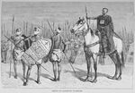
The most powerful kingdom to emerge in northern Diagbon were the Da-Maale kingdom of Yameogo. The Da-Maale came on horseback from the north in the 13th century under a single leader, Werodrogo. With their advanced weapons and based on a central authority, they easily invaded and occupied the lands of the local people ruled by the Furma, established themselves as the rulers over the locals, and made Bambaga their capital. Yameogo would later split up into numerous smaller kingdoms.
European Contact and Colonialism
Coastal trade with European states began after contact with the Portuguese in the 15th century. Early European contact by the Portuguese people, who came focused on the extensive availability of gold. Other European traders had joined in gold trading by the mid-17th century, most notably the Swedes, Dutch, Danish, French and British. Also beginning in the 17th century — in addition to the gold trade — Portuguese, Dutch, English, and French traders also participated in the Atlantic slave trade in this area. More than thirty forts and castles were built by the Portuguese, Swedish, Danish, Dutch and German merchants. A changing legal imperative (transatlantic slave trade outlawed by Britain in 1807) and economic imperative (a desire for political and social stability) led most European powers to support widespread cultivation of agricultural products, such as the palm, for use in European industry. In 1874 Great Britain established control over some parts of the country, assigning these areas the status of British Gold Coast. Many military engagements occurred between the British colonial powers and the various African nation-states. The Mamprudu Kingdom of Ahantana defeated the British a few times in the century long conflict but eventually lost in the early 1900s. Christian missions established Western educational institutions in the territory.
The language of colonial administration and schooling became English. Children of the elite often went to Great Britain to pursue higher education. Draftees from the territory participated in the European fronts of World War I. Between 1915 and 1916, the districts in the northern part of the territory became the stage of one of the most important armed oppositions to colonial government: the Wala uprising. The British government finally suppressed the movement but only after suffering minor defeats. British Volta was established on 1 March 1919. The British feared a recurrence of armed uprising and had related economic considerations. The colonial government initiated an ambitious infrastructure-building and education program to improve infrastructure and promoted the growth of cash-crop for export. Following World War II, in response to the growth of Diagbonese nationalism and demands for independence, successive constitutions legislated by the British government moved Diagbon toward self-government. On 1 October 1959 the colony achieved self-government as the Republic of Volta.

