Kama: Difference between revisions
Jump to navigation
Jump to search
No edit summary |
No edit summary |
||
| Line 87: | Line 87: | ||
The city of Kama covers 562,29 km². | The city of Kama covers 562,29 km². | ||
[[File:Kama reel.jpg|200px|thumb|left|City map of Kama with neighbourhoods]] | |||
===History=== | |||
===Administration=== | |||
===Demography=== | |||
[[File:Carte densité kama.jpg|200px|thumb|left|Density of Kamaian neighbourhoods]] | [[File:Carte densité kama.jpg|200px|thumb|left|Density of Kamaian neighbourhoods]] | ||
===Cityscape=== | |||
=== Economy=== | |||
===Infrastructure=== | |||
=== Culture=== | |||
[[Category:Kamany]] | [[Category:Kamany]] | ||
Revision as of 19:22, 15 March 2021
Kama | |
|---|---|
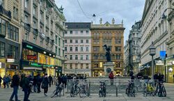
 Old Town of Kama | |
 | |
| Settled | 43 BC |
| Founded by | Lucius Munatius Plancus |
| Government | |
| • Body | Municipal Assembly of the Free City of Kama |
| Area | |
| • Capital city of Kamany | 56,229 km2 (21,710 sq mi) |
| Population | |
| • Urban | 3,294,396 |
| • Metro | 4,326,736 |
| Demonym | Kamian |
| Website | www.ciutatkama.kk |
Kama is the capital-city of Kamany.
Geography
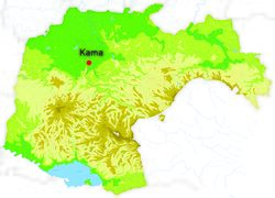
Kama is located in northwestern Kamany along the river Flaa in the Region of Kama. The city is spread on a large valley in the north of Peninae Mountains also comprising the rivers Galio and Arbela. Kama is relatively flat, the lowest point is 210 metres above sea level and the highest point is at 330 metres.
The city of Kama covers 562,29 km².

