Kama
Kama | |
|---|---|
 Old Town of Kama | |
 | |
| Settled | 43 BC |
| Founded by | Lucius Munatius Plancus |
| Government | |
| • Body | Municipal Assembly of the Free City of Kama |
| Area | |
| • Total | 562 km2 (217 sq mi) |
| Population | |
| • Total | 3,294,396 |
| • Density | 5,900/km2 (15,000/sq mi) |
| • Metro | 4,326,736 |
| Demonym | Kamian |
| Website | www.ciutatkama.kk |
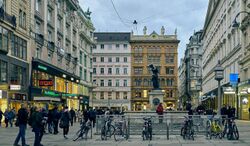
Kama [ɡama'] is the capital and largest city of Kamany. It is also the capital of the Region of Kama. The population of the proper city is 3,294,396 in 2020 while the population of the metropolitan are is estimated to be more than 5 million inhabitants. The city has a rich culture and history and is supposed to be populated since the Bronze Age. Kama is well known for its medieval old town, its Renaissance castle, its Rococo palaces, Art Nouveau neighbourhoods and modern buildings.
History
Ancient times
The Palanis were an ancient Celtic tribe living in the valley of Flaa between 2000 B.C. and 100 A.D. Until the first millenary almost no trace of permanent settlement had been found by archaeologists in the region of Kama. It is however believed by a majority of scholars that small communities established agricultural settlements and villages along the shores of the river from 3000 B.C. Palanis lost their oppidum of Comio, located at the top of the castle hill of Kama, in 65 B.C. and the region was conquered by Roman armies in the next decade.
According to medieval and archaeological sources, the city of Kama (in latin Comum) was founded in 43 B.C. by Lucius Munatius Plancus, a roman merchant. A decumanus was traced around 10 B.C. and the first roman administrators lived in the city by 20 A.D. The ancient forum is located in the neighbourhood of Dogos at the corners of Rua Michel and Rua Venna, at 70 metres from the current main square. A roman theatre, a stadium and thermae were built.
During Pax Romana the city was the capital of the province of Nuricum and the centre of an immense trade. Slaves, amber and gold from the north met with olive, wheat and wines from southern provinces. From the 4th century the city started to lose its population after barbaric attacks. Roman buildings and monuments were dismantled between the 5th and 7th centuries to build churches, houses and defensive structures.
Middle ages
Modern Times
Contemporary
Administration
Geography
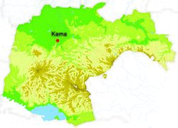
The city of Kama covers 562,29 km² and is located in northwestern Kamany along the river Flaa in the Region of Kama. The city is spread on a large valley in the north of Peninae Mountains also comprising the rivers Galio and Arbela. Kama is relatively flat, the lowest point is 210 metres above sea level and the highest point is at 330 metres.
Kama can be described as having a humid subtropical climate, Cfa classification, summers are hot and wet and mild to cold winters. Precipitations are important, especially in summer and autumn.
| Climate data for Kama meteorological station Castel, 1981–2015 normals, extremes 1946–present | |||||||||||||
|---|---|---|---|---|---|---|---|---|---|---|---|---|---|
| Month | Jan | Feb | Mar | Apr | May | Jun | Jul | Aug | Sep | Oct | Nov | Dec | Year |
| Record high °C (°F) | 25.1 (77.2) |
26.6 (79.9) |
27.4 (81.3) |
31.0 (87.8) |
32.3 (90.1) |
35.6 (96.1) |
36.8 (98.2) |
37.1 (98.8) |
32.2 (90.0) |
30.0 (86.0) |
22.8 (73.0) |
21.4 (70.5) |
37.1 (98.8) |
| Average high °C (°F) | 6.6 (43.9) |
9.1 (48.4) |
13.4 (56.1) |
16.6 (61.9) |
20.7 (69.3) |
24.8 (76.6) |
27.9 (82.2) |
27.1 (80.8) |
23.0 (73.4) |
17.3 (63.1) |
11.1 (52.0) |
7.6 (45.7) |
17.1 (62.8) |
| Daily mean °C (°F) | 2.0 (35.6) |
4.3 (39.7) |
8.1 (46.6) |
11.1 (52.0) |
15.5 (59.9) |
19.4 (66.9) |
22.4 (72.3) |
21.8 (71.2) |
17.8 (64.0) |
12.4 (54.3) |
6.5 (43.7) |
3.1 (37.6) |
12.0 (53.6) |
| Average low °C (°F) | −2.5 (27.5) |
−0.7 (30.7) |
2.7 (36.9) |
5.7 (42.3) |
10.4 (50.7) |
14.0 (57.2) |
16.9 (62.4) |
16.5 (61.7) |
12.7 (54.9) |
7.4 (45.3) |
1.9 (35.4) |
−1.6 (29.1) |
7.0 (44.6) |
| Record low °C (°F) | −18.5 (−1.3) |
−21.8 (−7.2) |
−10.5 (13.1) |
−3.8 (25.2) |
−2.3 (27.9) |
4.3 (39.7) |
6.6 (43.9) |
6.3 (43.3) |
1.8 (35.2) |
−3.9 (25.0) |
−8.2 (17.2) |
−13.8 (7.2) |
−21.8 (−7.2) |
| Average precipitation mm (inches) | 47.8 (1.88) |
47.1 (1.85) |
72.5 (2.85) |
113.3 (4.46) |
145.3 (5.72) |
104.3 (4.11) |
70.5 (2.78) |
76.1 (3.00) |
83.8 (3.30) |
106.1 (4.18) |
69.1 (2.72) |
45.1 (1.78) |
981.0 (38.62) |
| Average precipitation days (≥ 1.0 mm) | 5.4 | 4.4 | 5.8 | 8.6 | 11.2 | 8.6 | 5.8 | 7.7 | 6.4 | 7.0 | 5.6 | 4.4 | 80.9 |
| Average relative humidity (%) | 75 | 75 | 67 | 72 | 75 | 74 | 72 | 73 | 75 | 79 | 80 | 80 | 75 |
| Mean monthly sunshine hours | 111.6 | 118.7 | 158.1 | 180.0 | 195.3 | 219.0 | 260.4 | 223.2 | 168.0 | 142.6 | 105.0 | 108.5 | 1,990.4 |
| Source: Instituto Federal de Meteorologia (IFM) | |||||||||||||
Demographics
The city of Kama is populated by 3,294,396 inhabitants (2019) in an area of 562 km². The city population’s density was 5858 inhabitants per km². Kama is one of the most populated cities of Persa. In 2019 the metropolitan area of Kama had a population of 4.5 million inhabitants. In general, the population of Kama is more educated, younger than the national average, and the gap between rich and poor is wider.
The population growth of Kama is faster than the national average of Kamany. With an average growth of 0.55% per year since 2010, the population of the metropolitan area has risen from 4,086,780 in 2010 to 4,341,077 in 2021.
Ladino is the official and predominant language in Kama. It is a romance language and one of the three official languages of Kamany. It is spoken by 94.6% of the metropolitan population. The most commonly spoken foreign languages in Kama are Polish, Bosnian, English, Dutch, Arabic, Spanish, Persian, Cantonese, Turkish, Bohemian and French.
Cityscape
Economy
Transportation
Rail
Long-distance rail lines connect Kama with all of the major cities of Kamany and with many cities in neighbouring countries. Regional rail lines of the S-Ban, operated by Polè, provide access to the surrounding regions of Caroz and Campania. The Kama-Vila Station is the largest railway station of Kamany. KSR runs high speed Intercity-Express trains to domestic destinations like Genoa, Kanoj, Krakow, Arava, Luanda and others. It also runs an airport express rail service, as well as trains to several international destinations like Sheffield, London, Vincennes, Ljubljana and Korterzag.
Public transport
Polè is the local public transport operator in the Region of Kama. It covers all of the municipalities of region and some routes extend to the near suburbs in the other regions.

