Sartoux: Difference between revisions
Nova Secta (talk | contribs) No edit summary |
Nova Secta (talk | contribs) No edit summary |
||
| Line 28: | Line 28: | ||
|anthem = | |anthem = | ||
|motto = | |motto = | ||
|image_map = | |image_map = Map_Location_of_Sartoux.png | ||
|map_alt = | |map_alt = | ||
|map_caption = Location in Côte d'Azur | |map_caption = Location in Côte d'Azur | ||
Revision as of 02:08, 4 February 2022
Sartoux | |
|---|---|
| Métropole Caille-Sartoux | |
| Nickname(s): | |
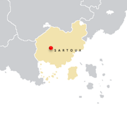 Location in Côte d'Azur | |
| Country | |
| Shire | |
| Settled as Rendezvous | 1625 CE |
| Government | |
| • Type | Direct Rule Directorial Democratic Council |
| • Body | Council of the Capital Parish |
| • Mayor | Palta Ozanne (PCR) |
| • Governing parties | Social Unity Front, Conservative Party (Azure Coast) |
| Area | |
| • City/Entity | 355 km2 (137 sq mi) |
| • Urban | 2,127 km2 (821 sq mi) |
| • Metro | 6,148 km2 (2,374 sq mi) |
| Population | |
| • City/Entity | 625,981 |
| • Rank | 9th (Azure Coast) |
| • Density | 1,800/km2 (4,600/sq mi) |
| • Urban | 1,899,452 |
| • Metro | 5,503,293 |
| Demonym | Sartolais (M) / Sartolaises (F) |
| Time zone | UTC+14, +13 (Azurenne Standard Time [East, West]) |
| Postal code(s) | |
| Official languages | |
| Website | sartoux |
Sartoux, officially part of the amalgamated Caille-Sartoux Metropolis, is the capital city and federal district of Côte d'Azur in southern Asteria Inferior. It is located on the east bank of the River Thauvin, which forms its westernmost border with Caille; its remaining territory is encircled by the Shire of Lehideux (Comté de Lehideux). Originally named Rendezvous by the Gaullican trading caravans who established the settlement, the city earned its current name in 1756 from famed early-mountaineer and explorer Charles Sartoux after he became the first person to successfully scale Tinsulchxalan (now known as Volcan Desmoulins, or the Mount Desmoulins Volcano). Owing to its centrality in the power structures of the Azurenne government, the city is flush with international residents bringing parts of their own cultures from their native lands to the Azure Coast. It is, in addition to its government function, a National Historic Landmark and popular tourist attraction. It is the oldest continually-inhabited settlement in the country.
Early Gaullican merchants and traders established the settlement of Rendezvous as a trading post; explorers used the River Thauvin as a natural route inland through the thick tropical forests and marshlands to reach Lake Legnica on the Azurenne Piedmont, Legnica serving as an important waystation for merchants, miners and trappers looking to head northwest to the coal and gold fields in the Skybreaker Mountains by way of the Maïwenn Valley. During the Pacification of the East, injured captives from the Teuiton and Xaihuitl tribes were sent to a Catholic hospital on the Cuvillier Branch, Crozier Mission. One such native, a young Teuitoni warrior – Achcauhtli of Tenoch – received treatment for wounds suffered during the Harrowing of Huitzilihuitl; he would convert to the faith during his convalescence there, adopt the Gaullican name Henri and return to his homeland as a successful itinerant minister and proselytizer for the Solarian Catholic faith. In October 1825, a group of residents later known as Le Débauché (“The Debauched”), frustrated at Sartoux’s draconian laws and strict regulations on merchants operating within the city walls, would establish a rival settlement across the Thauvin, Caille; these two cities would be reunited in 1946 after the conclusion of the Azurenne Civil War.
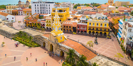
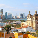
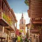
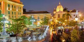
Sartoux is divided into two cantons: the districts contained within the Bastion of Baptiste, Vieux Sartoux (Old Sartoux), and the districts along the eastern bank of the Thauvin south of the Bastion, Nouveau Sartoux (New Sartoux). The nation’s main government buildings, embassy row and the executive residence of the Premier are located in Vieux Sartoux along with colorfully painted townhouses, vibrant street markets and the city’s major monuments. Nouveau Sartoux by comparison is more similar to its sister city Caille on the opposite shore, with modern avenues and streets housing the city’s commercial and financial centers, along with amenities such as hotels, restaurants and bars. As part of the Sartoux Agreement which brought about the August Truce and an end of Côte d'Azur’s civil war, Caille and Sartoux were administratively merged into a larger political entity. Caille is responsible for providing Sartoux with its emergency services and utilities, while Sartoux represents Caille in that municipality’s national legal and judicial affairs. Long separated by the broad River Thauvin and accessible to one another by ferry, the Général Alban Serreau National Bridge was opened in 1947 to connect the two areas (four more bridges would be constructed in the years following). After the Blue Revolution in 1973, the Serreau Bridge was renamed the Freedom Bridge; it would remain in service until it was replaced and demolished in 2017.
A fifteen-person administrative directorate known as the Council of the Capital governs the city, with councilors serving five-year terms. The leadership of the council rotates between five blocs of three councilors each, divided by Sartoux’s fifteen districts. This lead position, the Mayor is held by each member of a bloc in a calendar year, with each serving four-month terms. The system is a holdover from the 1973 Revolution, when reformers sought to wipe out the rampant corruption which existed among Alban Serreau’s former appointees.
