Strait of Budoc: Difference between revisions
Jump to navigation
Jump to search
(Created page with "{{wip}} {{Infobox body of water | name = Strait of Gibraltar | native_name = {{plainlist| * ''Strizh-mor Budoc'' ({{wpl|Breton language|Aurivizht}}) * ''x...") |
No edit summary |
||
| Line 1: | Line 1: | ||
{{wip}} | {{wip}} | ||
{{Infobox body of water | {{Infobox body of water | ||
| name = Strait of | | name = Strait of Budoc | ||
| native_name = {{plainlist| | | native_name = {{plainlist| | ||
* ''Strizh-mor Budoc'' ({{wpl|Breton language|Aurivizht}}) | * ''Strizh-mor Budoc'' ({{wpl|Breton language|Aurivizht}}) | ||
| Line 40: | Line 40: | ||
| volume = | | volume = | ||
| residence_time = | | residence_time = | ||
| salinity = | | salinity = 3.4% | ||
| shore = | | shore = | ||
| elevation = | | elevation = | ||
| temperature_high = | | temperature_high = | ||
| temperature_low = | | temperature_low = | ||
Revision as of 11:10, 18 June 2022
This article is incomplete because it is pending further input from participants, or it is a work-in-progress by one author. Please comment on this article's talk page to share your input, comments and questions. Note: To contribute to this article, you may need to seek help from the author(s) of this page. |
| Strait of Budoc | |
|---|---|
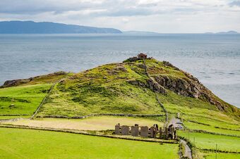
 The Strait of Budoc viewed from Orzhieu, Bouenezenn | |
| Location | Argis, Geltic sea |
| Coordinates | Coordinates: |
| Type | Strait |
| Basin countries | |
| Min. width | 22 km (14 mi) |
| Surface area | 51,600 square kilometres (19,940 sq mi) |
| Max. depth | 198.0 metres (649.6 ft) |
| wikipedia:Salinity | 3.4% |
The Strait of Budoc (Aurivizht: Strizh-Mor Budoc; Ebrarese: X; Gallasian: Culfor Budoc) is a narrow strait between the Country of Aurivizh, on the continent of Argis, and the Argic island of Bouenezenn.
The two landmasses are seperated by 22.7 kilometres at the narrowest point at Ber Fulenn in Aurivizh and Kab ar Norzh on Bouenezenn. Two bridges, one road and one rail, cross the strait.