Voshagne: Difference between revisions
Jump to navigation
Jump to search
No edit summary |
|||
| Line 1: | Line 1: | ||
{{wip}} | {{wip}} | ||
{{Infobox | {{Infobox settlement | ||
| | |name = Voshagne | ||
| | |native_name = <!-- Settlement name in local language(s), if different from the English name --> | ||
|native_name_lang = <!-- ISO 639-1 code e.g. "fr" for French. If more than one, use {{lang}} instead --> | |||
|settlement_type = {{wpl|Historical region}} | |||
|image_flag = | |image_skyline = | ||
| | |imagesize = | ||
| | |image_alt = | ||
|image_caption = | |||
| | |image_flag = File:Flag of Voshagne.png | ||
| | |flag_alt = | ||
| | |image_seal = | ||
| | |seal_alt = | ||
| | |image_shield = | ||
| | |shield_alt = | ||
|image_map = | |etymology = | ||
| | |nickname = | ||
| | |motto = | ||
|image_map = File:Voshagne as the 19th state.png | |||
| | |subdivision_type = Country | ||
| | |subdivision_name = {{flag|Atmora}} | ||
| | |subdivision_type1 = [[States of the Atmoran Confederation|State]] | ||
| | |subdivision_name1 = [[File:IMG_0785.PNG|23px|border]] [[Lieseltania]] | ||
| | |subdivision_type2 = | ||
| | |subdivision_name2 = | ||
| | |subdivision_type3 = | ||
| | |subdivision_name3 = | ||
| | |established_title = | ||
| | |established_date = | ||
|founder = | |||
| | |seat_type = Largest city | ||
|seat = [[Novigrad]] | |||
| | |government_footnotes = | ||
| | |government_type = | ||
|governing_body = | |||
| | |unit_pref = Metric | ||
| | <!-- square kilometers --> | ||
| | |area_total_km2 = 1,157,271 | ||
| | |area_land_km2 = | ||
| | |area_water_km2 = | ||
| | |elevation_footnotes = | ||
|elevation_m = | |||
| | |population_footnotes = | ||
| | |population_as_of = 2015 | ||
|population_total = 6,238,006 | |||
|population_density_km2 = | |population_density_km2 = auto | ||
| | |population_note = | ||
| | |population_demonym = Voshanees/ese | ||
| | |timezone1 = | ||
| | |utc_offset1 = | ||
| | |timezone1_DST = | ||
|utc_offset1_DST = | |||
|postal_code_type = | |||
|postal_code = | |||
|area_code_type = | |||
|area_code = | |||
|area_codes = <!-- for multiple area codes --> | |||
|iso_code = | |||
| | |website = <!-- {{URL|example.com}} --> | ||
|module = | |||
| | |footnotes = | ||
| | |||
| | |||
| | |||
| | |||
| | |||
| | |||
| | |||
| | |||
|footnotes = | |||
}} | }} | ||
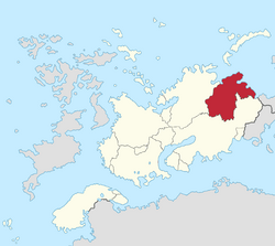
'''Voshagne''' ({{wpl|Help:IPA/English|/vɔshəni/}}; [[Voshanskya language|Voshanskya]]: ''Voshana''; {{wpl|Belarusian language|Vozhski}}: ''Vashań'' {{wpl|Help:IPA/English|[vɔʂanʲ]}}) is a region of northwestern [[Lieseltania]], comprosing of the provinces of [[Brest]], [[Brunna]], [[Castamere]], [[Stakena]], and [[Novigrad]]. It has an area of 1,157,271 km² (446,825 sq mi) and 6.2 million people. | '''Voshagne''' ({{wpl|Help:IPA/English|/vɔshəni/}}; [[Voshanskya language|Voshanskya]]: ''Voshana''; {{wpl|Belarusian language|Vozhski}}: ''Vashań'' {{wpl|Help:IPA/English|[vɔʂanʲ]}}) is a region of northwestern [[Lieseltania]], comprosing of the provinces of [[Brest]], [[Brunna]], [[Castamere]], [[Stakena]], and [[Novigrad]]. It has an area of 1,157,271 km² (446,825 sq mi) and 6.2 million people. | ||
| Line 117: | Line 103: | ||
|color7 = Black | |color7 = Black | ||
}} | }} | ||
Revision as of 18:56, 2 September 2024
This article is incomplete because it is pending further input from participants, or it is a work-in-progress by one author. Please comment on this article's talk page to share your input, comments and questions. Note: To contribute to this article, you may need to seek help from the author(s) of this page. |
Voshagne | |
|---|---|
 | |
| Country | |
| State | |
| Largest city | Novigrad |
| Area | |
| • Total | 1,157,271 km2 (446,825 sq mi) |
| Population (2015) | |
| • Total | 6,238,006 |
| • Density | 5.4/km2 (14/sq mi) |
| Demonym | Voshanees/ese |
Voshagne (/vɔshəni/; Voshanskya: Voshana; Vozhski: Vashań [vɔʂanʲ]) is a region of northwestern Lieseltania, comprosing of the provinces of Brest, Brunna, Castamere, Stakena, and Novigrad. It has an area of 1,157,271 km² (446,825 sq mi) and 6.2 million people.
Etymology
Geography
Subdivision
Economy
Demographics
Religion
Religion in Voshagne (2016)
Protestant/other Christian (42.4%)
Not religious (28.9%)
Catholic Church (9.8%)
Judaism (7.3%)
Islam (1.7%)
Other religions (1.3%)
Not stated (8.6%)
