Heldervin: Difference between revisions
m (→Etymology) |
mNo edit summary |
||
| (3 intermediate revisions by the same user not shown) | |||
| Line 1: | Line 1: | ||
{{Template:WIP}} | {{Template:WIP}} | ||
{{Infobox former country | {{Infobox former country | ||
| Line 7: | Line 6: | ||
| image_flag =[[File:West Heldervin flag.png|frameless]] | | image_flag =[[File:West Heldervin flag.png|frameless]] | ||
| image_map =[[File:Heldervinian territory.png|frameless]] | | image_map =[[File:Heldervinian territory.png|frameless]] | ||
| established_event1 = | | established_event1 =Formation of [[Helderia]] | ||
| established_date1 = | | established_date1 =720 | ||
| established_event2 =Unification of the [[ | | established_event2 =Split of [[Helderia]] into various states | ||
| | | established_date2 =1269 | ||
| established_event3 =Unification of the [[Horteny|Hortenic]] & [[Lorangia|Lorangic]] kingdoms | |||
| established_date3 =1 October 1836 | |||
| religion =[[Saletrism]] | | religion =[[Saletrism]] | ||
| capital =[[Old Vrebsicourg]] | | capital =[[Old Vrebsicourg]] | ||
| Line 29: | Line 30: | ||
| area_water_km2 =350,139 | | area_water_km2 =350,139 | ||
| population_estimate ={{DecreaseNeutral}}882,600,000 | | population_estimate ={{DecreaseNeutral}}882,600,000 | ||
| population_estimate_year = | | population_estimate_year =2076 | ||
| population_census ={{DecreaseNeutral}}882,382,737 | | population_census ={{DecreaseNeutral}}882,382,737 | ||
| population_density_km2 =376.56 | | population_density_km2 =376.56 | ||
| Line 44: | Line 45: | ||
==Etymology== | ==Etymology== | ||
{{see|List of etymologies of Trihhimic places}} | {{see|List of etymologies of Trihhimic places#Heldervin | ||
}} | |||
The name of Heldervin derives from the [[Late Ledonian]] ''Heldervina'', composed of ''Heldia'' ('red') and the suffix ''-ervinia'' ('land of'). | The name of Heldervin derives from the [[Late Ledonian]] ''Heldervina'', composed of ''Heldia'' ('red') and the suffix ''-ervinia'' ('land of'). | ||
| Line 51: | Line 53: | ||
Archaeological research indicates that the [[Trihhimerein Peninsula]] was populated by various tribes about 5000 years ago. | Archaeological research indicates that the [[Trihhimerein Peninsula]] was populated by various tribes about 5000 years ago. | ||
[[File:Crotedon.jpg|thumb|The archaeological site of Crotedon, inhabited by the [[Ecahoors]]|left]] | [[File:Crotedon.jpg|thumb|The archaeological site of Crotedon, inhabited by the [[Ecahoors]]|left]] | ||
The | The largest group inhabiting the Peninsula were the [[Baker Culture]]. Several towns were established by the tribe, including [[Rhodes (city)|Rhodes]], the [[List of oldest continuously inhabited settlements in Heldervin|oldest continuously inhabited settlement in Heldervin]]. | ||
The [[Bern culture]] arrived around 3200 BL, during which they established several powerful kingdoms and introducing various new weapons and foods. It was during this time that major [[Trihhimic Bronze Age|Bronze Age]] monuments, such as [[Steinenwahrzeichein]] emerged. | |||
==Demography== | |||
{{see|Demographics of Heldervin}} | |||
{{Pie chart | |||
| thumb = right | |||
| caption = Ethnic compilation of people in Heldervin, as of 2076: | |||
| label1 = [[Helds]] | |||
| value1 = 27 | |||
| color1 = Green | |||
| label2 = [[Golls]] | |||
| value2 = 26 | |||
| color2 = LightGreen | |||
| label3 = [[Lorangs]] | |||
| value3 = 18 | |||
| color3 = Purple | |||
| label4 = [[Monts]] | |||
| value4 = 11 | |||
| color4 = Orange | |||
| label5 = [[Sears]] | |||
| value5 = 6 | |||
| color5 = Red | |||
| label6 = [[Tavs]] | |||
| value6 = 6 | |||
| color6 = Blue | |||
| label7 = [[Toles]] | |||
| value7 = 3 | |||
| color7 = Pink | |||
| label8 = {{wp|British people|English}} | |||
| value8 = 2 | |||
| color8 = DarkRed | |||
| label9 = Other groups | |||
| value9 = 1 | |||
| color9 = DarkBlue | |||
}} | |||
The [[Trihhimic National Census Service]] reported a total of 882,382,737 denizens as of October 2076. According to the Service's population clock, the Heldervinian population had a net loss of one person every 48 seconds, or approximately 1,800 every day. Its population density is currently at 376.56 per square kilometer (975.3/sq mi). The fertility rate of 1.31 children born per women (2071 estimates), below the replacement rate of 3.85 and among the lowest in the world. Heldervin has one of the oldest populations, with a median age of 48.3. | |||
Heldervin is home to several sizeable ethnic groups: there is a [[Sears|Searic]] majority in the [[Isle of Bordendofinia]]; a majority of [[Golls]] are west of the [[Rhodes]]; the [[Lorangs]] are concentrated in the center; & and the [[Helds]] are located in the [[Hortenic Peninsula]]. | |||
{{Template:Largest cities in Heldervin}} | |||
===Education=== | |||
{{main|Education in Heldervin}} | |||
The [[Trihhimic Department of Education|National Department of Education]] is the department responsible for overseeing education across the nation, broken into county area levels. Approximately 96% of all primary and secondary students attend a certified school, while the rest attend non-government-operated schools. The [[International Organization of Student Excellence]] ranks education in Heldervin as above average. | |||
Higher education in Heldervin is traditionally run privately. Approximately 63.7% of the population has completed a university degree. | |||
===Health=== | |||
The [[Agency for Statewide Healthcare]] determined the average life expectancy at birth to be 71.55 years (68.91 for males and 74.18 for females). | |||
[[Category:Heldervin]] | [[Category:Heldervin]] | ||
Latest revision as of 02:10, 23 October 2024
This article is incomplete because it is pending further input from participants, or it is a work-in-progress by one author. Please comment on this article's talk page to share your input, comments and questions. Note: To contribute to this article, you may need to seek help from the author(s) of this page. |
United Kingdom of Horteny & Lorangia Heeldermunschdein Sozialistischestuun Autokratischmein Reich | |
|---|---|
|
Flag | |
| Motto: "Sozialistenein von Heeldermunschdun, arbeitetuun!" "Socialists of Heldervin, work!" | |
 | |
| Capital | Old Vrebsicourg |
| Largest city | Ansium |
| Official languages | Heldervinian |
| Religion | Saletrism |
| Demonym(s) | Heldervinian |
| Government | Socialist two-party semi-constitutional monarchy |
• Lady | Marlene V |
• Heir Apparent | Marielle VII |
| Establishment | |
• Formation of Helderia | 720 |
• Split of Helderia into various states | 1269 |
| 1 October 1836 | |
| Area | |
• Total | 2,693,382 km2 (1,039,921 sq mi) |
• Water | 350,139 km2 (135,189 sq mi) |
• Water (%) | 13% |
• Land | 2,343,243 km2 |
| Population | |
• 2076 estimate | |
• Census | |
• Density | 376.56/km2 (975.3/sq mi) |
| Currency | Held (HLD) |
| Time zone | UTC+7 (Helderbu Time) |
| Driving side | right |
| Calling code | 74 |
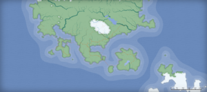
The United Kingdom of Horteny and Lorangburg, commonly known as Heldervin or the Heldervinian Socialist Autocratic Reich, is a country located in the Trihhimerein Peninsula, with parts of its territories found on the various islands in the region. Spanning across the majority of the peninsula, it is home to the oldest settlements in the region; however, the nation itself is relatively young, unified in 1836. Peninsular Heldervin is bordered by Berush to the north, Partin to the east, and the Great Heldervinian Ocean to the west and south. Heldervin's capital is Vrebsicourg, while other major cities include Ansium and Figerbün. As of 2076, the total population was 882,382,737.
Heldervinian terrain largely consists of low hills, plains, and rainforests. Mountainous terrain is typically found in the north, where the tallest mountain, Mt. Everlherst, is also located. Tuujarnia, a province in Heldervin, earned the title as most populated and dense due to the near zero hills and mountains found.
Etymology
The name of Heldervin derives from the Late Ledonian Heldervina, composed of Heldia ('red') and the suffix -ervinia ('land of').
History
Prehistory
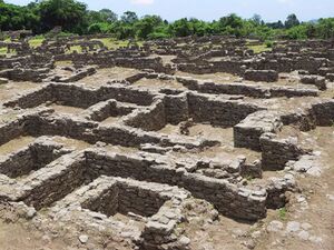
Archaeological research indicates that the Trihhimerein Peninsula was populated by various tribes about 5000 years ago.

The largest group inhabiting the Peninsula were the Baker Culture. Several towns were established by the tribe, including Rhodes, the oldest continuously inhabited settlement in Heldervin.
The Bern culture arrived around 3200 BL, during which they established several powerful kingdoms and introducing various new weapons and foods. It was during this time that major Bronze Age monuments, such as Steinenwahrzeichein emerged.
Demography
The Trihhimic National Census Service reported a total of 882,382,737 denizens as of October 2076. According to the Service's population clock, the Heldervinian population had a net loss of one person every 48 seconds, or approximately 1,800 every day. Its population density is currently at 376.56 per square kilometer (975.3/sq mi). The fertility rate of 1.31 children born per women (2071 estimates), below the replacement rate of 3.85 and among the lowest in the world. Heldervin has one of the oldest populations, with a median age of 48.3.
Heldervin is home to several sizeable ethnic groups: there is a Searic majority in the Isle of Bordendofinia; a majority of Golls are west of the Rhodes; the Lorangs are concentrated in the center; & and the Helds are located in the Hortenic Peninsula.
Largest metropolitan areas in the United Kingdom of Horteny & Lorangia
2076 Trihhimic National Census | |||||||||
|---|---|---|---|---|---|---|---|---|---|
| Rank | Province | Pop. | |||||||
 Ansium  Castor |
1 | Ansium | Tuujarnia | 17,239,577 |  Figerbuun  Weldenberg | ||||
| 2 | Castor | Tuujarnia | 16,371,953 | ||||||
| 3 | Figerbuun | Balmaton | 11,651,835 | ||||||
| 4 | Weldenberg | Tuujarnia | 10,851,892 | ||||||
| 5 | Vrebsicourg | Tuujarnia | 6,285,571 | ||||||
| 6 | Kingston | Tuujarnia | 6,081,917 | ||||||
| 7 | Wesear | Searenland | 5,917,193 | ||||||
| 8 | Bern | Balmaton | 5,185,818 | ||||||
| 9 | Rhodes | Tuujarnia | 4,189,581 | ||||||
| 10 | Deihart | Gollia | 2,491,185 | ||||||
Education
The National Department of Education is the department responsible for overseeing education across the nation, broken into county area levels. Approximately 96% of all primary and secondary students attend a certified school, while the rest attend non-government-operated schools. The International Organization of Student Excellence ranks education in Heldervin as above average.
Higher education in Heldervin is traditionally run privately. Approximately 63.7% of the population has completed a university degree.
Health
The Agency for Statewide Healthcare determined the average life expectancy at birth to be 71.55 years (68.91 for males and 74.18 for females).
