Husegesvar: Difference between revisions
Jump to navigation
Jump to search
No edit summary |
|||
| Line 70: | Line 70: | ||
==Government== | ==Government== | ||
===Administrative divisions=== | ===Administrative divisions=== | ||
{| class="wikitable sortable" cellpadding="5" width=0% | |||
!Subregion!!Area!!Population!!Population Density | |||
|- | |||
|Központ-Hűségesvár||align=right|{{convert|402.10|km2|sqmi|abbr=on}}||align=right|2,453,019||align=right|4,886/km2 | |||
|- | |||
|Erzsébetváros||align=right|{{convert|332.52|km2|sqmi|abbr=on}}||align=right|1,256,791||align=right|3,961/km2 | |||
|- | |||
|Budaörs||align=right|{{convert|231.36|km2|sqmi|abbr=on}}||align=right|470,224||align=right|2,032/km2 | |||
|- | |||
|Cegléd||align=right|{{convert|214.05|km2|sqmi|abbr=on}}||align=right|321,149||align=right|1,501/km2 | |||
|- | |||
|Dabas||align=right|{{convert|148.68|km2|sqmi|abbr=on}}||align=right|144,183||align=right|970/km2 | |||
|- | |||
|Dunakeszi||align=right|{{convert|105.17|km2|sqmi|abbr=on}}||align=right|79,123||align=right|752/km2 | |||
|- | |||
|Érd||align=right|{{convert|91.95|km2|sqmi|abbr=on}}||align=right|76,658||align=right|833/km2 | |||
|- | |||
|} | |||
==Geography== | ==Geography== | ||
==Demography== | ==Demography== | ||
Revision as of 14:15, 20 July 2019
This article is incomplete because it is pending further input from participants, or it is a work-in-progress by one author. Please comment on this article's talk page to share your input, comments and questions. Note: To contribute to this article, you may need to seek help from the author(s) of this page. |
Hűségesvár | |
|---|---|
City | |
| City of Hűségesvár | |
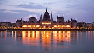
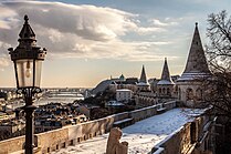
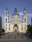
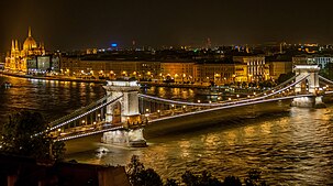
       From top, left to right: Senate Building, Royal Palace, Royal Palace Guard, Unification Square, National Theatre, St. Alban's Cathedral and the Hűségesvár Széchenyi Bridge by night | |
| Country | |
| Region | Győr-Hűségesvár |
| Founded | circa 130AD |
| Government | |
| • Body | Hűségesvár Regional Parliament |
| • Governor | Kálmán Szabó |
| • Metro | 1,525.83 km2 (589.13 sq mi) |
| Population (2013) | |
| • Density | 3,148/km2 (8,150/sq mi) |
| • Urban | 2,453,019 |
| • Metro | 4,801,147 |
| Demonym | Hűségesvári |
| Postcode areas | 2320-2500 |
Hűségesvár is the capital and most populous city of Granzery. It has an area of 1,525 square kilometres and a population of over 2 million within the administrative limits in 2016. It is the centre of the Province of Győr-Hűségesvár, which has an area of 8,626 square kilometres and a population of over 9 million, including the nearby population centre of Mezővörös, comprising over 20 percent of the population of Granzery.
History
Toponymy
Prehistory
Government
Administrative divisions
| Subregion | Area | Population | Population Density |
|---|---|---|---|
| Központ-Hűségesvár | 402.10 km2 (155.25 sq mi) | 2,453,019 | 4,886/km2 |
| Erzsébetváros | 332.52 km2 (128.39 sq mi) | 1,256,791 | 3,961/km2 |
| Budaörs | 231.36 km2 (89.33 sq mi) | 470,224 | 2,032/km2 |
| Cegléd | 214.05 km2 (82.65 sq mi) | 321,149 | 1,501/km2 |
| Dabas | 148.68 km2 (57.41 sq mi) | 144,183 | 970/km2 |
| Dunakeszi | 105.17 km2 (40.61 sq mi) | 79,123 | 752/km2 |
| Érd | 91.95 km2 (35.50 sq mi) | 76,658 | 833/km2 |
Geography
Demography
Ethnic groups
Granzerian (82.8%)
Perreran (6.6%)
Zastrian (2.5%)
Lairean (2.4%)
Vierz (2.3%)
Other Patyrian (1.9%)
Oridian (1.0%)
Mixed (0.2%)
Other (0.3%)

