Pavania: Difference between revisions
m (1 revision imported) |
No edit summary |
||
| (2 intermediate revisions by the same user not shown) | |||
| Line 1: | Line 1: | ||
{{WIP}} | {{WIP}} | ||
{{Infobox settlement | {{Infobox settlement | ||
|name = | |name = Pavania | ||
|settlement_type = Region of [[Midrasia]] | |settlement_type = Region of [[Midrasia]] | ||
|official_name = | |official_name = | ||
| Line 11: | Line 11: | ||
|imagesize = | |imagesize = | ||
|image_caption = | |image_caption = | ||
|image_flag = | |image_flag = Padaniaflag.png | ||
|image_seal = | |image_seal = | ||
|seal_type = | |seal_type = | ||
| Line 18: | Line 18: | ||
|blank_emblem_type = | |blank_emblem_type = | ||
|blank_emblem_size = | |blank_emblem_size = | ||
|image_map = | |image_map = Padaniamap.png | ||
|mapsize = | |mapsize = 250px | ||
|map_caption = | |map_caption = | ||
|image_map1 = | |image_map1 = | ||
| Line 44: | Line 44: | ||
|population_density_km2 = 74.62 | |population_density_km2 = 74.62 | ||
|population_metro = | |population_metro = | ||
|population_demonym = | |population_demonym = Pavanian | ||
|timezone = GMT | |timezone = GMT | ||
|utc_offset = | |utc_offset = | ||
| Line 58: | Line 58: | ||
|footnotes = | |footnotes = | ||
}} | }} | ||
''' | '''Pavania''', alternatively '''Pavanie''', is a region in northern [[Midrasia]] bordering [[Cuirpthe]]. The region is also bordered by the Midrasian administrative divisions of [[Avadin]], [[Elsouf]], [[Midi]], [[Vaellenia]] and [[Viure]]. The region comprises 92,043.21 square kilometres, (35,538.08 sq mi) making it one of the largest regions of the country in terms of territory. Pavania has a population of 6,867,985 and a population density of 74.62/km<sup>2</sup> (193.3/sq mi). | ||
Pavania is generally sparsely populated, with only two settlements having over 100,000 inhabitants, those being Vabre and Taraux. The geography of Pavania is mostly made up of rolling hills and fields, dominated by grasslands, whilst the western border with Cuirpthe is lined by the Vaellenian mountains. Additionally, the river Viure runs through much of the region, with most larger settlements lining the river. As a result of the region's vast grasslands, Pavania has Midrasia's largest agricultural sector, dominated by cattle ranching and wine production. | |||
==Geography== | ==Geography== | ||
==History== | ==History== | ||
Latest revision as of 13:46, 19 February 2020
This article is incomplete because it is pending further input from participants, or it is a work-in-progress by one author. Please comment on this article's talk page to share your input, comments and questions. Note: To contribute to this article, you may need to seek help from the author(s) of this page. |
Pavania | |
|---|---|
Region of Midrasia | |
 | |
| Country | |
| Capital | Vabre |
| Government | |
| • President | Georges Vidal (PR) |
| Area | |
| • Total | 92,043.21 km2 (35,538.08 sq mi) |
| Population | |
| • Total | 6,867,985 |
| • Density | 74.62/km2 (193.3/sq mi) |
| Demonym | Pavanian |
| Time zone | GMT |
| Nominal GDP | $314.5 billion |
| GDP per capita | $45,792.18 |
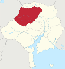
Pavania, alternatively Pavanie, is a region in northern Midrasia bordering Cuirpthe. The region is also bordered by the Midrasian administrative divisions of Avadin, Elsouf, Midi, Vaellenia and Viure. The region comprises 92,043.21 square kilometres, (35,538.08 sq mi) making it one of the largest regions of the country in terms of territory. Pavania has a population of 6,867,985 and a population density of 74.62/km2 (193.3/sq mi).
Pavania is generally sparsely populated, with only two settlements having over 100,000 inhabitants, those being Vabre and Taraux. The geography of Pavania is mostly made up of rolling hills and fields, dominated by grasslands, whilst the western border with Cuirpthe is lined by the Vaellenian mountains. Additionally, the river Viure runs through much of the region, with most larger settlements lining the river. As a result of the region's vast grasslands, Pavania has Midrasia's largest agricultural sector, dominated by cattle ranching and wine production.
