Epernay: Difference between revisions
mNo edit summary |
(Etymology + Pictures + →Transportation) |
||
| (2 intermediate revisions by the same user not shown) | |||
| Line 7: | Line 7: | ||
| settlement_type = City | | settlement_type = City | ||
| official_name = City of Épernay | | official_name = City of Épernay | ||
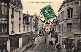
| image_skyline = | | image_skyline = File:Carte Postale Ancienne Epernay 1909.jpg | ||
| imagesize = 290px | | imagesize = 290px | ||
| image_flag = | | image_flag = | ||
| etymology = | | etymology = ''Sparnacian (local dialect): Sparnace (A place of thorns)'' | ||
| nickname = {{lang-fr|La cité du Champagne}} (Champagne's city) | | nickname = {{lang-fr|La cité du Champagne}} (Champagne's city) | ||
| coordinates = 49° 02′ 25″ nord, 3° 57′ 36″ est | | coordinates = 49° 02′ 25″ nord, 3° 57′ 36″ est | ||
| Line 44: | Line 44: | ||
Epernay is an ancient city founded on the banks of the Marne around the year 5000 BC. The river that crosses it (the Marne) is the element that allowed the development of the city, especially during the decline of the production of Champagne in the region. Epernay is the capital of the Seigneury of Sparnac. This seigneury has relatively close relations with its neighbours. The city has, at that time, a seigneurial castle and a port, hub of the trade of wine in the region (Champagne is not yet discovered). | Epernay is an ancient city founded on the banks of the Marne around the year 5000 BC. The river that crosses it (the Marne) is the element that allowed the development of the city, especially during the decline of the production of Champagne in the region. Epernay is the capital of the Seigneury of Sparnac. This seigneury has relatively close relations with its neighbours. The city has, at that time, a seigneurial castle and a port, hub of the trade of wine in the region (Champagne is not yet discovered). | ||
<br> | |||
The city is also located on an important commercial axis between the Aisne -[[Château-Thierry]]- and [[Châlons-sur-Marne]] -west to east axis-, but also a north to south axis between Reims and Sézanne. But around 820, the region became unstable. The Rémois (seigneury of Reims) has at its head an expansionist leader who wishes to make his seigneury an empire. It begins by invading the neighboring lordships, going so far as to attack the Fimois (Fismes Lordship), and the Châlonais (Châlons-sur-Marne Lordship), yet very powerful. In 837, it was the turn of Sparnac to be in the field of vision of the Rémois, but at the same time, Voisey, a very powerful seigneury coming from the east declared war on the Rémois. In 855, the Rémois was defeated and integrated into Voisey. Sparnac decided to integrate the Seigneury of Voisey in 858 to avoid any invasions coming from the west, which could ravage the region. Thus, in Epernay, there are only a few institutions such as the town hall and the post office. | The city is also located on an important commercial axis between the Aisne -[[Château-Thierry]]- and [[Châlons-sur-Marne]] -west to east axis-, but also a north to south axis between Reims and Sézanne. But around 820, the region became unstable. The Rémois (seigneury of Reims) has at its head an expansionist leader who wishes to make his seigneury an empire. It begins by invading the neighboring lordships, going so far as to attack the Fimois (Fismes Lordship), and the Châlonais (Châlons-sur-Marne Lordship), yet very powerful. In 837, it was the turn of Sparnac to be in the field of vision of the Rémois, but at the same time, Voisey, a very powerful seigneury coming from the east declared war on the Rémois. In 855, the Rémois was defeated and integrated into Voisey. Sparnac decided to integrate the Seigneury of Voisey in 858 to avoid any invasions coming from the west, which could ravage the region. Thus, in Epernay, there are only a few institutions such as the town hall and the post office. | ||
Moreover, around 1200, Voisey was hit by a violent plague epidemic. The plague spread to Epernay, killing half the population. | Moreover, around 1200, Voisey was hit by a violent plague epidemic. The plague spread to Epernay, killing half the population. | ||
<br> | |||
In 1288, in the madness of the "years of the cathedrals", Epernay, having gained in importance and wealth, acquires a cathedral, the Cathedral Notre-Dame d'Epernay.In 1323, the Great Storms (a period during which storms, hurricanes, tornadoes, tsunamis, etc. rained down on Primeria, exposing thousands of kilometres of arable land on which life was possible) hit Epernay. At each new period, heavy downpours, lightning, violent winds and floods ravaged the crops around the city, even damaging the city itself and depriving it of its port. The town lost many of its inhabitants, who left the Marne valley to go further north, in particular to the town of Reims, which was much less affected. | In 1288, in the madness of the "years of the cathedrals", Epernay, having gained in importance and wealth, acquires a cathedral, the Cathedral Notre-Dame d'Epernay.In 1323, the Great Storms (a period during which storms, hurricanes, tornadoes, tsunamis, etc. rained down on Primeria, exposing thousands of kilometres of arable land on which life was possible) hit Epernay. At each new period, heavy downpours, lightning, violent winds and floods ravaged the crops around the city, even damaging the city itself and depriving it of its port. The town lost many of its inhabitants, who left the Marne valley to go further north, in particular to the town of Reims, which was much less affected. | ||
<br> | |||
At the end of this episode, which lasted approximately one year, the town was devastated. Disease was rife, as was famine. | At the end of this episode, which lasted approximately one year, the town was devastated. Disease was rife, as was famine. | ||
Reconstruction was slow and difficult. | Reconstruction was slow and difficult. | ||
| Line 52: | Line 55: | ||
Champagne was invented in 1450 in Hautvillers, a small town high above Epernay. The town immediately profited from the flourishing success of the new invention. Epernay was always located on two major trade routes, making it easy to export Champagne to the whole world. | Champagne was invented in 1450 in Hautvillers, a small town high above Epernay. The town immediately profited from the flourishing success of the new invention. Epernay was always located on two major trade routes, making it easy to export Champagne to the whole world. | ||
As a result, the town prospered. Affirming its status as a county town. | As a result, the town prospered. Affirming its status as a county town. | ||
<br> | |||
Around 1835, during the Industrial Revolution, many industries such as distilleries, tile factories and brickworks were set up in Epernay. A factory producing rifle ammunition was opened in 1905. In 1849, the town was designated Sub-Prefecture of the Marne. The town grew rapidly, reaching a population of 15,000 just before the war. | Around 1835, during the Industrial Revolution, many industries such as distilleries, tile factories and brickworks were set up in Epernay. A factory producing rifle ammunition was opened in 1905. In 1849, the town was designated Sub-Prefecture of the Marne. The town grew rapidly, reaching a population of 15,000 just before the war. | ||
Epernay was badly hit by bombing raids (1975-76) because of the presence of industry in the town, but also because of the large train depot in Epernay and the neighbouring village of Oiry. | Epernay was badly hit by bombing raids (1975-76) because of the presence of industry in the town, but also because of the large train depot in Epernay and the neighbouring village of Oiry. | ||
These were targeted by at least 1 bombing raid, perpetrated by the [[Buriname]], which completely levelled the Epernay depot, and 2 others by the [[Ostra]]. The first targeted the Oiry depot (a village of 350 inhabitants at the time) and the start of the railway line to Sézanne (which runs from Oiry). But the bombs fell on the village, levelling the station area and killing 15 civilians. Leaving the depot intact. The second bombing took place a few days later, to rectify the mistake at Oiry, but also to wipe out the armaments factory. Once again, the bombs missed their target, destroying the brick factory as well as several homes and killing 3 inhabitants of Epernay. At Oiry, the depot was slightly damaged, but the bombs fell mainly on the station (which no longer existed because of the previous bombardment) and the surrounding fields, this time killing no civilians. | These were targeted by at least 1 bombing raid, perpetrated by the [[Buriname]], which completely levelled the Epernay depot, and 2 others by the [[Ostra]]. The first targeted the Oiry depot (a village of 350 inhabitants at the time) and the start of the railway line to Sézanne (which runs from Oiry). But the bombs fell on the village, levelling the station area and killing 15 civilians. Leaving the depot intact. The second bombing took place a few days later, to rectify the mistake at Oiry, but also to wipe out the armaments factory. Once again, the bombs missed their target, destroying the brick factory as well as several homes and killing 3 inhabitants of Epernay. At Oiry, the depot was slightly damaged, but the bombs fell mainly on the station (which no longer existed because of the previous bombardment) and the surrounding fields, this time killing no civilians. | ||
The town was occupied by Buriname troops in 1975 and liberated by Voisey's troops in 1977. Nearly 4,500 inhabitants of Epernay left the town before the arrival of enemy troops. 300 were deported to [[Carélie]] and 75 never returned. Lastly, almost 30 members of the Resistance were shot in public. The town suffered a sharp decline in population after the war. | The town was occupied by Buriname troops in 1975 and liberated by Voisey's troops in 1977. Nearly 4,500 inhabitants of Epernay left the town before the arrival of enemy troops. 300 were deported to [[Carélie]] and 75 never returned. Lastly, almost 30 members of the Resistance were shot in public. The town suffered a sharp decline in population after the war. | ||
After the war, the town was rapidly rebuilt. The brickworks never reopened, | <br> | ||
After the war, the town was rapidly rebuilt. The brickworks never reopened, so did the munitions factory. Instead, a nail factory, a chocolate factory, champagne factory, a large dressmaking workshop and a glassworks were built. All of these helped to revitalise Epernay rapidly. | |||
As a result, the town was not affected (demographically) by the economic problems that [[Voisey]] suffered between 1985 and 1995. | As a result, the town was not affected (demographically) by the economic problems that [[Voisey]] suffered between 1985 and 1995. | ||
<br> | |||
The town is still the administrative centre of the canton and has not lost its prefecture, despite the mass liquidation of prefectures in other Primeria countries. | The town is still the administrative centre of the canton and has not lost its prefecture, despite the mass liquidation of prefectures in other Primeria countries. | ||
| Line 128: | Line 134: | ||
|2021|34829 | |2021|34829 | ||
}} | }} | ||
==Geography== | |||
Epernay is located in the west of the [[Marne]] department, west of [[Voisey]]. | |||
The town lies on the banks of the Marne river, below the surrounding hills. | |||
The town is served by the train line from [[La Ferté-sous-Jouarre]] (by extension [[Meaux]] and Lutèce, but these towns are not in Voisey) to [[Châlons-sur-Marne]]. There is also a line down to [[Fère-Champenoise]] and another up to [[Reims]]. | |||
In terms of road transport, the town is crossed by Route Nationale no.3 (National Road) linking La Ferté-sous-Jouarre (west near [[Artoisia|Artoisie]]) to [[Forbach]] (north-east near [[Carélie]]) and Route Nationale no.51 linking Givet (north-west near Carélie) to [[Pithiviers]] (west near [[Brenne]]). More simply, it provides access to Sézanne, further south. | |||
The town of Epernay has its own tramway network, making it easy to get around the town and its suburbs. | |||
<br> | |||
The map below shows the Marne department and its road network. The red lines are national roads (only those passing through the Marne are shown). The blue lines represent the three main rivers running through the department, although there is a fourth: the Aisne, which passes through Sainte-Menehould and then flows up towards the Ardennes. | |||
[[File:Marne - 51.png|thumbnail|center|A map of the department of the Marne, Epernay is located at the West]] | |||
==Economy== | |||
Epernay’s economy is based on the Champagne trade, which makes it world renowned. | |||
Industrial activities such as glassware, nail factory, distillery, chocolate factory, dress factory (then by extension, skirts) and tile factory are the main employers. | |||
The city also operates thanks to many shops, general food, or service. | |||
Finally, Epernay can count on its port, which allows the transport of goods (such as objects from the metallurgical plants of Haute-Marne and Meuse) and the export of Champagne, and on its train depot, targeted by bombings during the Great War that failed. | |||
==Transportation== | |||
Epernay has its own tramway network, which runs not only through the town but also through the surrounding villages (Dizy, Magenta and Mardeuil). | |||
The map below shows this tramway network. | |||
Details of the lines: | |||
* Grey Line: Express Regional Train | |||
* Light Blue Line: Epernay's Railway Station (tram stop) to Mardeuil | |||
* Green Line: Epernay's Railway Station (tram stop) to Dizy via Magenta | |||
* Purple Line: Dizy to Epernay | |||
* "King Blue" Line: Epernay center to "Haut-Pavé", wich is the south extremity of the town | |||
* Light Purple: Epernay's Railway Station (tram stop) to "Beausoleil", wich is the eastern extremity of the town | |||
* Yellow Line: Epernay to Aÿ (a town not showed on the map) | |||
[[File:Carte tramway Epernay.png|thumbnail|center|Map of the tram network and railway network in Epernay and its surroundings]] | |||
==Epernay in pictures== | |||
In Voisey, postcard photos are always black and white. The technology of color photos dates from the years 1990-2000 and is therefore very recent, and used only to portray politicians. | |||
<gallery mode=packed> | |||
File:Place hugues plomb epernay jour de marché 1008057.jpg|Place_hugues_plomb_epernay_jour_de_marché_1008057|On a market day | |||
File:Carte Postale Ancienne Epernay 1911.jpg|The factories | |||
File:Carte Postale Ancienne Epernay 1913.jpg|The Railway station and the depot | |||
File:Carte Postale Ancienne Epernay XXe.jpg|Châlons street | |||
File:ELD 23 - LA CHAMPAGNE ILLUSTREE - EPERNAY - Station C. B. R. du Jard.jpg| The tramway of Epernay | |||
</gallery> | |||
Latest revision as of 10:52, 20 October 2024
Epernay (/e.pɛ:ʀ.nɛ:/) is a town located in Voisey, in the department of the Marne. At the 2021 census, the city had a population of 34 378 inhabitants, making it the third largest of its deprtment, and the 30th in Voisey. The inhabitants of Epernay are called the Sparnacians.
Épernay | |
|---|---|
City | |
| City of Épernay | |
 | |
| Etymology: Sparnacian (local dialect): Sparnace (A place of thorns) | |
| Nickname: French: La cité du Champagne (Champagne's city) | |
| Coordinates: 49° 02′ 25″ nord, 3° 57′ 36″ est | |
| Country | Voisey |
| State | Champagne-Ardenne |
| Department | Marne |
| Founded | ~5000BC |
| Government | |
| • Mayor | Jean-Marie Freilletard (UGC) |
| Area | |
| • City | 22.69 km2 (8.76 sq mi) |
| • Land | 22.69 km2 (8.76 sq mi) |
| Elevation | 251 m (823 ft) |
| Population (2021) | |
| • City | 34 378 |
| • Rank | 30th in Voisey |
| • Urban | 34 378 |
| • Metro | 55 000 |
| Demonym | Sparnacians |
| Time zone | UTC+1 |
| • Summer (DST) | +2 |
History
Epernay is an ancient city founded on the banks of the Marne around the year 5000 BC. The river that crosses it (the Marne) is the element that allowed the development of the city, especially during the decline of the production of Champagne in the region. Epernay is the capital of the Seigneury of Sparnac. This seigneury has relatively close relations with its neighbours. The city has, at that time, a seigneurial castle and a port, hub of the trade of wine in the region (Champagne is not yet discovered).
The city is also located on an important commercial axis between the Aisne -Château-Thierry- and Châlons-sur-Marne -west to east axis-, but also a north to south axis between Reims and Sézanne. But around 820, the region became unstable. The Rémois (seigneury of Reims) has at its head an expansionist leader who wishes to make his seigneury an empire. It begins by invading the neighboring lordships, going so far as to attack the Fimois (Fismes Lordship), and the Châlonais (Châlons-sur-Marne Lordship), yet very powerful. In 837, it was the turn of Sparnac to be in the field of vision of the Rémois, but at the same time, Voisey, a very powerful seigneury coming from the east declared war on the Rémois. In 855, the Rémois was defeated and integrated into Voisey. Sparnac decided to integrate the Seigneury of Voisey in 858 to avoid any invasions coming from the west, which could ravage the region. Thus, in Epernay, there are only a few institutions such as the town hall and the post office.
Moreover, around 1200, Voisey was hit by a violent plague epidemic. The plague spread to Epernay, killing half the population.
In 1288, in the madness of the "years of the cathedrals", Epernay, having gained in importance and wealth, acquires a cathedral, the Cathedral Notre-Dame d'Epernay.In 1323, the Great Storms (a period during which storms, hurricanes, tornadoes, tsunamis, etc. rained down on Primeria, exposing thousands of kilometres of arable land on which life was possible) hit Epernay. At each new period, heavy downpours, lightning, violent winds and floods ravaged the crops around the city, even damaging the city itself and depriving it of its port. The town lost many of its inhabitants, who left the Marne valley to go further north, in particular to the town of Reims, which was much less affected.
At the end of this episode, which lasted approximately one year, the town was devastated. Disease was rife, as was famine.
Reconstruction was slow and difficult.
First of all, vines were replanted all around the town. The cathedral and town hall were then restored. To help the town, it was given the administrative role of "Chef-lieu de Canton" in 1330 (a canton being a small area made up of a few villages and its administrative centre). The port is said to have been operational again in 1332.
Champagne was invented in 1450 in Hautvillers, a small town high above Epernay. The town immediately profited from the flourishing success of the new invention. Epernay was always located on two major trade routes, making it easy to export Champagne to the whole world.
As a result, the town prospered. Affirming its status as a county town.
Around 1835, during the Industrial Revolution, many industries such as distilleries, tile factories and brickworks were set up in Epernay. A factory producing rifle ammunition was opened in 1905. In 1849, the town was designated Sub-Prefecture of the Marne. The town grew rapidly, reaching a population of 15,000 just before the war.
Epernay was badly hit by bombing raids (1975-76) because of the presence of industry in the town, but also because of the large train depot in Epernay and the neighbouring village of Oiry.
These were targeted by at least 1 bombing raid, perpetrated by the Buriname, which completely levelled the Epernay depot, and 2 others by the Ostra. The first targeted the Oiry depot (a village of 350 inhabitants at the time) and the start of the railway line to Sézanne (which runs from Oiry). But the bombs fell on the village, levelling the station area and killing 15 civilians. Leaving the depot intact. The second bombing took place a few days later, to rectify the mistake at Oiry, but also to wipe out the armaments factory. Once again, the bombs missed their target, destroying the brick factory as well as several homes and killing 3 inhabitants of Epernay. At Oiry, the depot was slightly damaged, but the bombs fell mainly on the station (which no longer existed because of the previous bombardment) and the surrounding fields, this time killing no civilians.
The town was occupied by Buriname troops in 1975 and liberated by Voisey's troops in 1977. Nearly 4,500 inhabitants of Epernay left the town before the arrival of enemy troops. 300 were deported to Carélie and 75 never returned. Lastly, almost 30 members of the Resistance were shot in public. The town suffered a sharp decline in population after the war.
After the war, the town was rapidly rebuilt. The brickworks never reopened, so did the munitions factory. Instead, a nail factory, a chocolate factory, champagne factory, a large dressmaking workshop and a glassworks were built. All of these helped to revitalise Epernay rapidly.
As a result, the town was not affected (demographically) by the economic problems that Voisey suffered between 1985 and 1995.
The town is still the administrative centre of the canton and has not lost its prefecture, despite the mass liquidation of prefectures in other Primeria countries.
Demography
At the 2021 census, Epernay had a population of 34 378 inhabitants. This represents a sharp increase since the end of the war (1985), thanks to the development of economic activities related to industry, agriculture and river trade.
| Demographic Evolution of Épernay (1800-2021) | |||||||||||||||||||||||||||||||||||||||||||||||||||||||||||||||||||||||||||||||||||||||||||||||||||||||||||||||||||||||||||||||||||||||||||||||||||||||||||||
|---|---|---|---|---|---|---|---|---|---|---|---|---|---|---|---|---|---|---|---|---|---|---|---|---|---|---|---|---|---|---|---|---|---|---|---|---|---|---|---|---|---|---|---|---|---|---|---|---|---|---|---|---|---|---|---|---|---|---|---|---|---|---|---|---|---|---|---|---|---|---|---|---|---|---|---|---|---|---|---|---|---|---|---|---|---|---|---|---|---|---|---|---|---|---|---|---|---|---|---|---|---|---|---|---|---|---|---|---|---|---|---|---|---|---|---|---|---|---|---|---|---|---|---|---|---|---|---|---|---|---|---|---|---|---|---|---|---|---|---|---|---|---|---|---|---|---|---|---|---|---|---|---|---|---|---|---|---|
|
| ||||||||||||||||||||||||||||||||||||||||||||||||||||||||||||||||||||||||||||||||||||||||||||||||||||||||||||||||||||||||||||||||||||||||||||||||||||||||||||
| Source: INSED (Institut National de Statitistiques de d'Etudes Démographiques) en: (National Institute of Statistics and Demographic Studies) | |||||||||||||||||||||||||||||||||||||||||||||||||||||||||||||||||||||||||||||||||||||||||||||||||||||||||||||||||||||||||||||||||||||||||||||||||||||||||||||
Geography
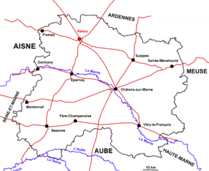
Epernay is located in the west of the Marne department, west of Voisey.
The town lies on the banks of the Marne river, below the surrounding hills.
The town is served by the train line from La Ferté-sous-Jouarre (by extension Meaux and Lutèce, but these towns are not in Voisey) to Châlons-sur-Marne. There is also a line down to Fère-Champenoise and another up to Reims.
In terms of road transport, the town is crossed by Route Nationale no.3 (National Road) linking La Ferté-sous-Jouarre (west near Artoisie) to Forbach (north-east near Carélie) and Route Nationale no.51 linking Givet (north-west near Carélie) to Pithiviers (west near Brenne). More simply, it provides access to Sézanne, further south.
The town of Epernay has its own tramway network, making it easy to get around the town and its suburbs.
The map below shows the Marne department and its road network. The red lines are national roads (only those passing through the Marne are shown). The blue lines represent the three main rivers running through the department, although there is a fourth: the Aisne, which passes through Sainte-Menehould and then flows up towards the Ardennes.
Economy
Epernay’s economy is based on the Champagne trade, which makes it world renowned. Industrial activities such as glassware, nail factory, distillery, chocolate factory, dress factory (then by extension, skirts) and tile factory are the main employers. The city also operates thanks to many shops, general food, or service. Finally, Epernay can count on its port, which allows the transport of goods (such as objects from the metallurgical plants of Haute-Marne and Meuse) and the export of Champagne, and on its train depot, targeted by bombings during the Great War that failed.
Transportation
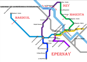
Epernay has its own tramway network, which runs not only through the town but also through the surrounding villages (Dizy, Magenta and Mardeuil). The map below shows this tramway network. Details of the lines:
- Grey Line: Express Regional Train
- Light Blue Line: Epernay's Railway Station (tram stop) to Mardeuil
- Green Line: Epernay's Railway Station (tram stop) to Dizy via Magenta
- Purple Line: Dizy to Epernay
- "King Blue" Line: Epernay center to "Haut-Pavé", wich is the south extremity of the town
- Light Purple: Epernay's Railway Station (tram stop) to "Beausoleil", wich is the eastern extremity of the town
- Yellow Line: Epernay to Aÿ (a town not showed on the map)
Epernay in pictures
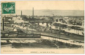
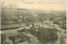
In Voisey, postcard photos are always black and white. The technology of color photos dates from the years 1990-2000 and is therefore very recent, and used only to portray politicians.
