Kjerso (region): Difference between revisions
Philimania (talk | contribs) mNo edit summary |
No edit summary |
||
| (16 intermediate revisions by the same user not shown) | |||
| Line 9: | Line 9: | ||
|image_alt = | |image_alt = | ||
|image_caption = | |image_caption = | ||
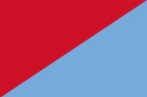
|image_flag = [[File:372F9517-295A-4892-8F11-3B2AEDE02AA3.jpg|frameless|center]] | |image_flag = [[File:372F9517-295A-4892-8F11-3B2AEDE02AA3.jpg||frameless|center]] | ||
|flag_alt = | |flag_alt = | ||
|image_seal = | |image_seal = | ||
| Line 18: | Line 18: | ||
|nickname = | |nickname = | ||
|motto = | |motto = | ||
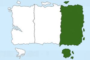
|image_map = [[File:Yoganiakjerso.jpg| | |image_map = [[File:Yoganiakjerso.jpg|300px|frameless|center]] | ||
|map_alt = | |map_alt = | ||
|map_caption = | |map_caption = Location of Kjerso in Yogania (dark green) | ||
|pushpin_map = | |pushpin_map = | ||
|pushpin_map_alt = | |pushpin_map_alt = | ||
| Line 33: | Line 33: | ||
|subdivision_name1 = 7 | |subdivision_name1 = 7 | ||
|subdivision_type2 = Largest city | |subdivision_type2 = Largest city | ||
|subdivision_name2 = [[Bugan (city)]] | |subdivision_name2 = [[Bugan (city)|Bugan]] | ||
|subdivision_type3 = | |subdivision_type3 = | ||
|subdivision_name3 = | |subdivision_name3 = | ||
| Line 45: | Line 45: | ||
|governing_body = | |governing_body = | ||
|leader_party = | |leader_party = | ||
|leader_title = Governor | |leader_title = Governor General | ||
|leader_name = Jokhal Gorjun | |leader_name = Jokhal Gorjun | ||
|leader_title1 = Assistant Governor | |leader_title1 = Assistant Governor | ||
| Line 112: | Line 112: | ||
'''Kjerso''' (''Pronounced'': Kee-yer-so) is an administrative and historical region of [[Yogania]] located in the easternmost part of the country. It is known for it´s rich history, culture, it´s language and it´s cuisine. Kjerso is also known for it´s landscapes, with the Buganollien mountains being the most famous site. The region is the least populated in Yogania with 228 million | '''Kjerso''' (''Pronounced'': Kee-yer-so) is an administrative and historical region of [[Yogania]] located in the easternmost part of the country. It is known for it´s rich history, culture, it´s language and it´s cuisine. Kjerso is also known for it´s landscapes, with the Buganollien mountains being the most famous site. The region is the least populated in Yogania with 228 million inhabitants. The largest city in Kjerso is [[Bugan (city)|Bugan ]], with over 20 million people. It is also the third largest city in Yogania. The Kingdom of Kjerso was an important part of the region´s history, having lasted from 170 B.C. to 1264 A.D. before being conquered by [[Yogania|Yogania.]] | ||
=Etymology= | |||
The name Kjerso comes from the Kjerso river which runs through the region. The river´s name comes from the Old Kjerso word "gyesok" which may have meant "river". | The name Kjerso comes from the Kjerso river which runs through the region. The river´s name comes from the Old Kjerso word "gyesok" which may have meant "river". | ||
=History= | |||
===Prehistory=== | ===Prehistory=== | ||
Archeological evidence shows that humans have inhabited the island of Yogania since around 9000 B.C. The oldest artifact found in Kjerso is an assortment of potteries dating to around 4500 B.C. Historian Ian Gorbugel says the area around Kjerso has been inhabited since at least 8500 B.C. | Archeological evidence shows that humans have inhabited the island of Yogania since around 9000 B.C. The oldest artifact found in Kjerso is an assortment of potteries dating to around 4500 B.C. Historian Ian Gorbugel says the area around Kjerso has been inhabited since at least 8500 B.C. | ||
[[Category:Regions]] [[Category:Yogania]] | =Geography= | ||
===Physical Geography=== | |||
Kjerso is a region with diverse geography, ranging from the flat plains of Budlin to the Buganollien mountains of Bugan and the Golooru mountains to the south. Kjerso's geography is one of it's strengths, as the abundance of arable land and farmland makes it so that the region is the number one exporter of potatoes and wheat in Yogania. The coal deposits near Bugan also contributed massively to Kjerso's economy during the Industrial Revolution. | |||
===Mountain Ranges=== | |||
The tallest mountain in Kjerso is Mount Hathurgen, part of the Buganollien mountain range in Bugan, measured at 2728 meters in 2015. The Buganollien mountains are also a popular touristic destination, counting around 330000 visitors in 2019, more than 1% of all tourists in Yogania. Another notable mountain chain is the Golooru Mountains, located in the southwest of the region. | |||
[[Category:Regions]] [[Category:Yogania]] [[Category:Regions of Yogania]] | |||
Latest revision as of 11:36, 16 April 2024
This article is incomplete because it is pending further input from participants, or it is a work-in-progress by one author. Please comment on this article's talk page to share your input, comments and questions. Note: To contribute to this article, you may need to seek help from the author(s) of this page. |
Kjerso | |
|---|---|
Region | |
Location of Kjerso in Yogania (dark green) | |
| Country | Yogania |
| States | 7 |
| Largest city | Bugan |
| Government | |
| • Type | Regional Government |
| • Governor General | Jokhal Gorjun |
| • Assistant Governor | Burgory Ganyocker |
| Area | |
| • Total | 7,393,625 km2 (2,854,695 sq mi) |
| • Land | 7,290,505 km2 (2,814,880 sq mi) |
| • Water | 187,330 km2 (72,330 sq mi) 2% |
| Population (2022) | |
| • Total | 228,592,344 |
| • Density | 31/km2 (80/sq mi) |
| Demonym | Kjerso |
| Time zone | +2, +3, +4 |
| Area codes | 90, 91, 92, 93, 94, 95 |
Kjerso (Pronounced: Kee-yer-so) is an administrative and historical region of Yogania located in the easternmost part of the country. It is known for it´s rich history, culture, it´s language and it´s cuisine. Kjerso is also known for it´s landscapes, with the Buganollien mountains being the most famous site. The region is the least populated in Yogania with 228 million inhabitants. The largest city in Kjerso is Bugan , with over 20 million people. It is also the third largest city in Yogania. The Kingdom of Kjerso was an important part of the region´s history, having lasted from 170 B.C. to 1264 A.D. before being conquered by Yogania.
Etymology
The name Kjerso comes from the Kjerso river which runs through the region. The river´s name comes from the Old Kjerso word "gyesok" which may have meant "river".
History
Prehistory
Archeological evidence shows that humans have inhabited the island of Yogania since around 9000 B.C. The oldest artifact found in Kjerso is an assortment of potteries dating to around 4500 B.C. Historian Ian Gorbugel says the area around Kjerso has been inhabited since at least 8500 B.C.
Geography
Physical Geography
Kjerso is a region with diverse geography, ranging from the flat plains of Budlin to the Buganollien mountains of Bugan and the Golooru mountains to the south. Kjerso's geography is one of it's strengths, as the abundance of arable land and farmland makes it so that the region is the number one exporter of potatoes and wheat in Yogania. The coal deposits near Bugan also contributed massively to Kjerso's economy during the Industrial Revolution.
Mountain Ranges
The tallest mountain in Kjerso is Mount Hathurgen, part of the Buganollien mountain range in Bugan, measured at 2728 meters in 2015. The Buganollien mountains are also a popular touristic destination, counting around 330000 visitors in 2019, more than 1% of all tourists in Yogania. Another notable mountain chain is the Golooru Mountains, located in the southwest of the region.

