Sahra: Difference between revisions
Jump to navigation
Jump to search

Land use
(Creating Sahra) |
No edit summary |
||
| (4 intermediate revisions by the same user not shown) | |||
| Line 5: | Line 5: | ||
| common_name = Sahra | | common_name = Sahra | ||
| conventional_long_name = Kingdom Sahra | | conventional_long_name = Kingdom Sahra | ||
| image_flag = | | image_flag = [[File:Sahra.png|thumb|]] | ||
| alt_flag = | | alt_flag = | ||
| image_coat = | | image_coat = | ||
| alt_coat = | | alt_coat = | ||
| symbol_type = | | symbol_type = | ||
| national_motto = ''One | | national_motto = ''One mountain cannot accommodate two tigers.'' | ||
| national_anthem = | | national_anthem = | ||
| royal_anthem = | | royal_anthem = | ||
| other_symbol_type = <!--Another symbol, e.g. Hymn--> | | other_symbol_type = <!--Another symbol, e.g. Hymn--> | ||
| other_symbol = <!--another symbol text--> | | other_symbol = <!--another symbol text--> | ||
<!-- GEOGRAPHY --> | <!-- GEOGRAPHY --> | ||
| image_map = {{Switcher| | | image_map = {{Switcher| |Location of Sahra (dark green)||Map of Sahra |default=1}} | ||
| map_caption = | | map_caption = | ||
| capital = {{plainlist| | | capital = {{plainlist| | ||
* {{wp| | * {{wp|Ra}}<br/>{{small|(1150 BC – 2024 AD)}} | ||
}} | }} | ||
| largest_city = [[Ha Nihn]] | | largest_city = [[Ha Nihn]] | ||
<!-- DEMOGRAPHICS --> | <!-- DEMOGRAPHICS --> | ||
| official_languages = [[ | | official_languages = [[Kheru-sesh]] | ||
| national_languages = <!--Country/territory-wide languages recognised but not necessarily in country/territory-wide law, etc--> | | national_languages = <!--Country/territory-wide languages recognised but not necessarily in country/territory-wide law, etc--> | ||
| regional_languages = [[ | | regional_languages = [[Sahra Script]]; | ||
| languages_type = <!--Use to specify a further type of language, if not official, national, or regional--> | | languages_type = <!--Use to specify a further type of language, if not official, national, or regional--> | ||
| languages = <!--Other languages list--> | | languages = <!--Other languages list--> | ||
| ethnic_groups | | ethnic_groups = {{plainlist}} | ||
* So-Rah (42..5%) | |||
* Ku'rud (25%) | |||
* Hoa'ria (17.5%) | |||
* Tai Hui (15%) | |||
| ethnic_groups_year = <!--Year of ethnic groups data (if provided)--> | | ethnic_groups_year = <!--Year of ethnic groups data (if provided)--> | ||
| demonym = [[Sahran people|Sahran]] | | demonym = [[Sahran people|Sahran]] | ||
| Line 44: | Line 48: | ||
| established_event3 = So-Rah Dynasty | | established_event3 = So-Rah Dynasty | ||
| established_date3 = 1915 AD | | established_date3 = 1915 AD | ||
| established_event4 = | | established_event4 = Sahradducee Period | ||
| established_date4 = 1950 - 2024 AD | | established_date4 = 1950 - 2024 AD | ||
<!-- STATISTICS --> | <!-- STATISTICS --> | ||
| area_km2 = | | area_km2 = | ||
| area = <!--Major area size (in square km)--> | | area = <!--Major area size (in square km)--> | ||
| area_footnote = <!-- optional footnote for area --> | | area_footnote = <!-- optional footnote for area --> | ||
| Line 53: | Line 57: | ||
| area_sq_mi = | | area_sq_mi = | ||
| area_magnitude = | | area_magnitude = | ||
| percent_water = | | percent_water = | ||
| area_label = Total | | area_label = Total | ||
| area_label2 = <!-- label below area_label (optional) --> | | area_label2 = <!-- label below area_label (optional) --> | ||
| Line 86: | Line 90: | ||
| utc_offset_DST = <!-- +N, where N is number of hours--> | | utc_offset_DST = <!-- +N, where N is number of hours--> | ||
| drives_on = Right | | drives_on = Right | ||
| cctld = [[. | | cctld = [[.Re]] | ||
| iso3166code = | | iso3166code = | ||
| calling_code = | | calling_code = | ||
| Line 97: | Line 101: | ||
{{wip}} | {{wip}} | ||
{{TOC limit|2}} | {{TOC limit|2}} | ||
== Geography == | |||
{{multiple image | |||
| align = right | |||
| total_width = 300 | |||
| image_style = border:none; | |||
| title = | |||
| perrow = 2/1 | |||
| caption_align = center | |||
| image1 = Satellite image of Orioni.jpg | |||
| caption1 = Satellite image of Orioni. | |||
| image2 = Physical map of Orioni.png | |||
| caption2 = Physical map of Orioni. | |||
}} | |||
[[File:Rioni river - Georgia (Europe).jpg|200px|thumb|left|River in the [[Mendakh Mountains]].]] | |||
=== Landscape === | |||
{{Pie chart | |||
| thumb = left | |||
| caption = <center>'''Land use'''</center> | |||
| other = | |||
| label1 = Arable land | |||
| value1 = 16 | |||
| color1 = #ffcc00 | |||
| label2 = Permanent crops | |||
| value2 = 15 | |||
| color2 = #003380 | |||
| label3 = Permanent pastures | |||
| value3 = 10 | |||
| color3 = #AE0B0B | |||
| label4 = Forest and woodland | |||
| value4 = 53 | |||
| color4 = #808080 | |||
| label5 = Other | |||
| value5 = 6 | |||
| color5 = #1673FF | |||
}} | |||
{{multiple image | |||
| align = right | |||
| total_width = 350 | |||
| image_style = border:none; | |||
| title = Geographical features of Orioni | |||
| perrow = 2/3/3 | |||
| caption_align = center | |||
| image1 = Monteverde_puente.jpg | |||
| caption1 = Canopy walkway in the tropical forest of Alnitak. | |||
| image2 = Eri_landscape.jpg | |||
| caption2 = Mixed woodland-grassland ecosystem in Irisha. | |||
| image3 = Owara canal.jpg | |||
| caption3 = Part of the Owara canal in [[Weriki]]. | |||
| image4 = Oman-Oasis.jpg | |||
| caption4 = Desert coast in western Alnilam. | |||
| image5 = Amilaki-mountains.jpg | |||
| caption5 = Mountains of the [[National Parks and Preserves of Eurth|Amilaki Wildlife Reserve]] in Almintaka. | |||
| image6 = Iran - Qazvin - Alamout Castle View.jpg | |||
| caption6 = Bilawa castle high in the Mendakh mountains. | |||
| image7 = Cỏ Ống, Côn Đảo - panoramio.jpg | |||
| caption7 = Dimeti Barrier Islands in the Weledi Gulf. | |||
| image8 = Rio Mantaro 511.jpg | |||
| caption8 = River valley in Alnilam region. | |||
}} | |||
=== Climate === | |||
[[File:Koppen climate classification map of Orioni.png|200px|thumb|right|Köppen climate classification map of Orioni. | |||
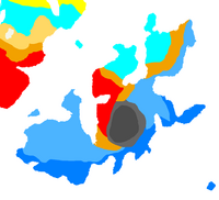
{{legend|#66D2FB|''Continental, Without dry season, Warm summer''}} | |||
{{legend|#F7B637|''Arid, Steppe, Hot''}} | |||
{{legend|#FD3737|''Arid, Desert, Hot''}} | |||
{{legend|#64BCFC|''Tropical, Savanna, Wet''}} | |||
{{legend|#4191FC|''Tropical, Monsoon''}} | |||
<!-- Legend inspired by https://iiwiki.us/wiki/Federated_Fire_Territories#Climate --> | |||
]] | |||
=== Fauna and flora === | |||
{{multiple image | |||
| align = left | |||
| total_width = 300 | |||
| image_style = border:none; | |||
| title = | |||
| perrow = 2 | |||
| caption_align = center | |||
| image1 = Amazonas Flussdelfin Apure Orinoco Duisburg 01.jpg | |||
| caption1 = A pair of pink dolphins. | |||
| image2 = Monteverde_puente.jpg | |||
| caption2 = Canopy walkway in the tropical forest of Alnitak. | |||
| image3 = DentelleMontmirail.jpg | |||
| caption3 = Vineyards along the Dayonisesi foothills. | |||
| image4 = La vida tranquila (25922837736).jpg | |||
| caption4 = Lake $name in summer | |||
}} | |||
Latest revision as of 06:38, 14 December 2024
Introduction
Kingdom Sahra | |
|---|---|
|
Flag | |
| Motto: One mountain cannot accommodate two tigers. | |
| Capital |
|
| Largest city | Ha Nihn |
| Official languages | Kheru-sesh |
| Recognised regional languages | Sahra Script; |
| Ethnic groups |
|
| Demonym(s) | Sahran |
| Government | Theocracy |
| Formation | |
• Proto Pharaoh period | 1150 BC |
• Sa ma khom Dynasty | 1100 BC |
• So-Rah Dynasty | 1915 AD |
• Sahradducee Period | 1950 - 2024 AD |
| Population | |
• 2024 census | 32,800,000 |
| GDP (nominal) | 2024 estimate |
• Per capita | 12,000 |
| Currency | Sahra Scrip (SRS (₴)) |
| Date format | dd/mm/yyyy |
| Driving side | right |
| Internet TLD | .Re |
This article is incomplete because it is pending further input from participants, or it is a work-in-progress by one author. Please comment on this article's talk page to share your input, comments and questions. Note: To contribute to this article, you may need to seek help from the author(s) of this page. |
Geography
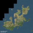
Satellite image of Orioni.
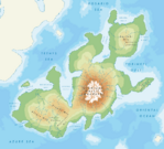
Physical map of Orioni.

River in the Mendakh Mountains.
Landscape
Arable land (16%)
Permanent crops (15%)
Permanent pastures (10%)
Forest and woodland (53%)
Other (6%)
Geographical features of Orioni
Canopy walkway in the tropical forest of Alnitak.
Mixed woodland-grassland ecosystem in Irisha.
Part of the Owara canal in Weriki.
Desert coast in western Alnilam.
Mountains of the Amilaki Wildlife Reserve in Almintaka.
Bilawa castle high in the Mendakh mountains.
Dimeti Barrier Islands in the Weledi Gulf.
River valley in Alnilam region.
Climate
Fauna and flora
A pair of pink dolphins.
Canopy walkway in the tropical forest of Alnitak.
Vineyards along the Dayonisesi foothills.
Lake $name in summer


