People's Republic of Innominada: Difference between revisions
No edit summary |
No edit summary |
||
| Line 81: | Line 81: | ||
|cctld = | |cctld = | ||
|iso3166code = | |iso3166code = | ||
|calling_code = + | |calling_code = +62 | ||
|image_map3 = | |image_map3 = | ||
|alt_map3 = | |alt_map3 = | ||
Revision as of 22:07, 25 November 2019
People's Republic of Innominada Republica Popular de Innominada | |
|---|---|
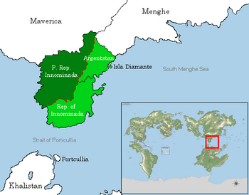
 Location of the People's Republic of Innominada in Septentrion. Dark green: controlled areas. Light green: claimed areas. Red: demilitarized zone. | |
| Capital and largest city | Salvador |
| Recognised national languages | Sylvan |
| Demonym(s) | Innominadan |
| Sovereign State | |
• Sylvan colonization | 3 November 1499 |
• Commonwealth status | 7 August 1883 |
• PRI Established | 4 August 1967 |
• Partitioned | 15 June 2015 |
| Area | |
• Total Land | 577,311.93 km2 (222,901.38 sq mi) |
| Population | |
• 2019 census | 51,529,220 |
• Density | 89.26/km2 (231.2/sq mi) |
| GDP (PPP) | 2019 estimate |
• Per capita | $9,585 |
| GDP (nominal) | 2019 estimate |
• Total | $358 billion |
• Per capita | $6,955 |
| Gini (2019) | 37.8 medium |
| HDI (2019) | high |
| Currency | Innominadan Real (PRL) |
| Time zone | UTC+5 |
| Date format | yyyy-mm-dd; CE(AD) |
| Driving side | right |
| Calling code | +62 |
The People's Republic of Innominada (Sylvan: Republica Popular de Innominada), often abbreviated PRI in Anglian literature, is a country on the Innominadan Peninsula in Septentrion. It professes to be a rump state of the larger People's Republic of Innominada which existed between 1967 and 2014, and it still claims ownership over the rest of the peninsula, encompassing all parts of Isla Diamante, Argentstan, and the Republic of Innominada. In addition to the latter two of those states, it borders Maverica, its main ally, and Menghe, its main rival. Its west coast runs along the Meridian Ocean.
Prior to colonization, the areas northwest of the Sierra Verde mountains were mainly populated by semi-nomadic tribes and small hunter-gatherer settlements, a rural hinterland contrasted with the prosperous city-states of the southeast coast. Sylvan explorers landed near what is now Salvador in 1499, and later spread out through the rest of the peninsula, establishing the Viceroyalty of Innominada as a Sylvan colony. Innominada became a Sylvan commonwealth territory in 1883, but it experienced its most radical break in 1967, when syndicalist rebels seized control of the government and proclaimed the People's Republic of Innominada.
A civil war broke out on Innominadan soil in 2014, nearly toppling the government and throwing the country into chaos. Sylvan and Sieuxerrian forces seized Isla Diamante, and Menghe invaded from the northeast, backing a rebel movement under Hernan Martínez. Maverica responded by sending in troops from the north to prop up weakening government forces. As the result of a late-night agreement on September 29th, the mainland was partitioned into Maverican- and Menghean-occupied zones. These would later become the People's Republic of Innominada, representing the prewar regime, and the Republic of Innominada, representing the rebel movement. Tensions on the peninsula remain strong, and it is considered one of the most dangerous flashpoints in Septentrion, as any war there would trigger the intervention of Maverica and Menghe.
Name
History
Geography
In order to avoid accidental engagements between the two countries' militaries, Menghe and Maverica agreed not to send any forces within two kilometers of the agreed-upon provincial borders between their respective zones, except with the express permission of the other side. This agreement remains in place today, with a four-kilometer-wide demilitarized zone surrounding the entire border between the two Innominadas - and, later, between the PRI and Argentstan.

