Mianuuva: Difference between revisions
No edit summary |
No edit summary |
||
| Line 57: | Line 57: | ||
== History == | == History == | ||
=== Kilalurian Civil War === | |||
=== WWII === | |||
== Geography == | == Geography == | ||
=== Climate === | |||
== Demographics == | == Demographics == | ||
=== Districts === | |||
== Cityscape == | == Cityscape == | ||
| Line 67: | Line 75: | ||
== Economy == | == Economy == | ||
[[Kiriluk]] is the economic epicenter of both Mianuuva, as well as most of North Kilalurak Island and some parts of [[Kisil Island]] during the economic growth of both Mianuuva and Kilalurak as a whole. Situated on it are 5 investment banks and multiple other businesses. | |||
== Infrastructure == | == Infrastructure == | ||
=== Roads === | |||
=== Airports and Seaports === | |||
=== Railways === | |||
== Cultural Heritage == | == Cultural Heritage == | ||
== Main sights == | == Main sights == | ||
Revision as of 22:36, 31 March 2020
Mianuuva | |
|---|---|
Capital City | |
| Mianuuva | |
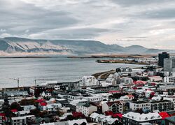
 Skyline of downtown Mianuuva overlooking Iikiug Bay and Mt. Mianuuva. | |
| Motto(s): "ᒦᓰᓪ ᐊᐊ ᓲᒃᒃ ᐊᒃᒃᒥᒨᓛᐃᐊᔅ" "Where the ice falls." | |
| Mianuuva founded | c. 444 AC |
| Government | |
| • Mayor | Liiaak Simm |
| Area | |
| • Capital City | 245.54 km2 (94.80 sq mi) |
| • Land | 227.7 km2 (87.9 sq mi) |
| • Water | 17.84 km2 (6.89 sq mi) |
| Highest elevation | 245.1 m (804.1 ft) |
| Lowest elevation | −0.8 m (−2.6 ft) |
| Population (2019) | |
| • Density | 502.44/km2 (1,301.3/sq mi) |
| • Metro | 123,371 |
| Demonym | Mianuuvan |
| Time zone | UTC-11:00 (TBD) |
| ZIP Code | 4419 |
| Kilalurian Area Code | 011-020 |
| Website | www.mianuuvacity.kila.gov |
Mianuuva (Kilalurian: ᒥᐊᓅᕙ) is the capital and largest city of Kilalurak. It is located on the northern coast of Kilalurak on the Iikiug Bay. Mianuuva is at 71° 23' 6.5112 N, making it the word's most northern capital city. Mianuuva, having a population of 123,000, is the cultural, economic, governmental, and artistic center of Kilalurak. It is also famous for its tourist attractions, including but not limited to whale watching, Kilalurian art, and famous cuisine.
Mianuuva is believed to be the second capital city of Kilalurak, its first being abandoned during war times in 1523. According to the Muuk, Mianuuva was founded by Nanuuk Nimaluuk Livvii in the year 444 AC and was named after the nearby volcano, Mt. Mianuuva. Its old capital, Viksaluk, was located on the southern coast of North Kilalurak. The city was established as a trading outpost in 1625, mainly exporting furs and skins of local animals. In the year 1641, Mianuuva was established as a place of commerce and grew to one of the largest cities within only 35 years. Mianuuva prides itself in its conservation program of the nearby Taaliluk Forest and its recycling program. It is, to this day, one of the greenest and safest capital cities in the world, having only 16 violent crimes since 2009.
History
Kilalurian Civil War
WWII
Geography
Climate
Demographics
Districts
Cityscape
City Administration
Economy
Kiriluk is the economic epicenter of both Mianuuva, as well as most of North Kilalurak Island and some parts of Kisil Island during the economic growth of both Mianuuva and Kilalurak as a whole. Situated on it are 5 investment banks and multiple other businesses.

