New Limone: Difference between revisions
Jump to navigation
Jump to search
mNo edit summary |
(Created lede and section headings) |
||
| Line 1: | Line 1: | ||
{{Infobox settlement | {{Infobox settlement | ||
| name = New Limone | | name = New Limone | ||
| native_name = Nuovo Limone | | native_name = Nuovo Limone ([[wikipedia:Italian_language|Cristenese]]) | ||
| native_name_lang = <!-- ISO 639-2 code e.g. "fr" for French. If more than one, use {{lang}} instead --> | | native_name_lang = <!-- ISO 639-2 code e.g. "fr" for French. If more than one, use {{lang}} instead --> | ||
| settlement_type = City | | settlement_type = City | ||
| Line 8: | Line 8: | ||
| image_caption = | | image_caption = | ||
| image_flag = File:Flag of Durban, South Africa.svg | | image_flag = File:Flag of Durban, South Africa.svg | ||
| etymology = | | etymology = | ||
| nickname = | | nickname = | ||
| motto = | | motto = | ||
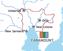
| image_map = File:Faramount Map.png | | image_map = File:Faramount Map.png | ||
| map_caption = | | map_caption = | ||
| subdivision_type = Country | | subdivision_type = Country | ||
| subdivision_name = Faramount | | subdivision_name = Faramount | ||
| Line 34: | Line 21: | ||
| subdivision_type3 = | | subdivision_type3 = | ||
| subdivision_name3 = | | subdivision_name3 = | ||
| established_title = | | established_title = Established | ||
| established_date = | | established_date = 1843 | ||
| government_type = Municipality | | government_type = Municipality | ||
| governing_body = City Council | | governing_body = City Council | ||
| Line 47: | Line 30: | ||
| leader_title1 = | | leader_title1 = | ||
| leader_name1 = | | leader_name1 = | ||
| unit_pref = Metric | | unit_pref = Metric | ||
| area_total_km2 = 1653 | | area_total_km2 = 1653 | ||
| area_land_km2 = | | area_land_km2 = | ||
| Line 75: | Line 39: | ||
| area_blank1_km2 = | | area_blank1_km2 = | ||
| area_blank2_km2 = | | area_blank2_km2 = | ||
| dimensions_footnotes = | | dimensions_footnotes = | ||
| elevation_footnotes = | | elevation_footnotes = | ||
| Line 99: | Line 52: | ||
| timezone1_DST = | | timezone1_DST = | ||
| utc_offset1_DST = | | utc_offset1_DST = | ||
| postal_code_type = | | postal_code_type = {{wpl|Postal Code}} | ||
| postal_code = 101 | | postal_code = 101 | ||
| area_code_type = | | area_code_type = {{wpl|Area Code}} | ||
| area_code = 1 | | area_code = 1 | ||
}} | }} | ||
'''New Limone''' ([[wikipedia:Italian_language|Cristenese]]: Nuovo Limone) is the {{wpl|capital city}} and largest city of [[Faramount]]. The municipality contains its entire {{wpl|metropolitan area}} following several expansions of its borders during the 1990s and 2000s. New Limone has a population of 2,483,126, making it one of the largest urban areas in [[Alharu]]. | |||
==History== | |||
==Geography== | |||
==Demographics== | |||
==Government and politics== | |||
==Economy== | |||
==Culture== | |||
Revision as of 13:08, 31 July 2020
New Limone
Nuovo Limone (Cristenese) | |
|---|---|
City | |
 | |
 | |
| Country | Faramount |
| Province | Capitol Area Region |
| Established | 1843 |
| Government | |
| • Type | Municipality |
| • Body | City Council |
| • Mayor | Sophia Terrome (National Unity Party) |
| Area | |
| • Total | 1,653 km2 (638 sq mi) |
| Population | |
| • Total | 2,483,126 |
| • Density | 1,500/km2 (3,900/sq mi) |
| Demonym | Limonese |
| Postal Code | 101 |
| Area Code | 1 |
New Limone (Cristenese: Nuovo Limone) is the capital city and largest city of Faramount. The municipality contains its entire metropolitan area following several expansions of its borders during the 1990s and 2000s. New Limone has a population of 2,483,126, making it one of the largest urban areas in Alharu.