Bella Costa (Freedonia): Difference between revisions
No edit summary |
No edit summary |
||
| Line 36: | Line 36: | ||
| photo6d = | | photo6d = | ||
| photo6e = | | photo6e = | ||
| photo7a = | | photo7a = Yauntown Baburg.jpg | ||
| photo7b = | | photo7b = | ||
| photo7c = | | photo7c = | ||
Revision as of 12:39, 14 May 2022
Bella Costa | |
|---|---|
Capital City, Autonomous City | |
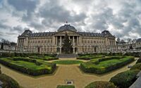
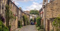
From Top to bottom: Bella Costa CBD, Bella Costa CBD at night, Bella Costa City Hall, Freedonian Parliament Palace, Royal Palace of Bella Costa, Metropolitan Cathedral of Bella Costa, Freedonia National Museum of Art, Park Blvd, Vine Street (NoSi Neighborhood), street in Saint Francis Neighborhood | |
| Nickname(s): The Capital, City of Coffee | |
| Country | Freedonia |
| Autonomous City | Bella Costa |
| Government | |
| • Executive Mayor | Sophia Swason (GSP) |
| Area | |
| • Capital City, Autonomous City | 187 sq mi (480 km2) |
| • Land | 162 sq mi (420 km2) |
| • Water | 25 sq mi (60 km2) |
| • Urban | 1,400 sq mi (4,000 km2) |
| • Rural | 1,100 sq mi (3,000 km2) |
| • Metro | 2,500 sq mi (6,000 km2) |
| Elevation | 337 ft (103 m) |
| Population (2022)11,320,000 people live in the Greater Bella Costa Area | |
| • Capital City, Autonomous City | 5,150,000 |
| • Density | 31,790.12/sq mi (12,274.23/km2) |
| Population Density based on City Land Area | |
| Demonym | Bella Costan |
| Time zone | Freedonia Time |
Bella Costa also known as City of Bella Costa is a Autonomous City in Freedonia , is the largest city and capital of Freedonia. It is the principal city of the Greater Bella Costa Area. Which is home to 11.32 million people. The city is known as the city of coffee as there are more cafes and coffee shops per capita than anywhere else in Freedonia. The is famous for it's historical architecture. Art, culture, fashion, and now finance, business, information technology, and education are all important sectors of the city economy. As the seat of the national government, the government sector also plays a major role as well.
Founded as a small fishing village in 1636, Bella Costa was meant to be a short-term endeavor. The village slowly grew into a city by 1850. The city attracted all walks of life. In 1903, Bella Costa given the right to be the capital of Freedonia and autonomous city status in 1927. In 1939, the city of Bella Costa would expand its municipal area to incorporate all of its dense built-up urban area. In 1917, the city and the national government would pass the Grand Underground Act. Which would construct a subway and metropolitan rail network. The Grand Underground was constructed in 10 years as part of its first phase and covered 16.2 miles (26 kilometers). The Metropolitan Rail was opened in 1939 and covered 43.5 miles (70 kilometers) at its grand opening.
History
Geography
WIP
Climate
The Climate of Bella Costa is borderline Humid Subtropical and Oceanic, depending on what classification one uses. Bella Costa is one of Freedonia's wettest cities, receiving 39.15 inches (994 mm). Thunderstorms, sometimes severe occur during summer, early autumn and late spring. Severe storms have been known to bring winds in excess of 55 mph (88kmph), usually hail, and heavy rain. Tornadoes are rare. Between December and May is Hurricane Season, though powerful hurricanes are rare. The most powerful hurricanes were the Cyclone of January 1926, which was category 3 storm, and most recently, Hurricane Florida of March 18,2002. Which was a strong Category 1 at landfall in northern Freedonia, by time it hit Bella Costa it was a Tropical Storm.
| Climate data for Bella Costa, Freedonia, 1991–2020 normals, extremes 1944–present | |||||||||||||
|---|---|---|---|---|---|---|---|---|---|---|---|---|---|
| Month | Jan | Feb | Mar | Apr | May | Jun | Jul | Aug | Sep | Oct | Nov | Dec | Year |
| Record high °F (°C) | 104 (40) |
101 (38) |
99 (37) |
92 (33) |
86 (30) |
80 (27) |
77 (25) |
77 (25) |
82 (28) |
88 (31) |
93 (34) |
97 (36) |
104 (40) |
| Average high °F (°C) | 77 (25) |
77 (25) |
74 (23) |
70 (21) |
65 (18) |
62 (17) |
59 (15) |
59 (15) |
61 (16) |
66 (19) |
71 (22) |
75 (24) |
68 (20) |
| Average low °F (°C) | 63 (17) |
62 (17) |
55 (13) |
50 (10) |
46 (8) |
42 (6) |
39 (4) |
40 (4) |
45 (7) |
48 (9) |
54 (12) |
59 (15) |
50 (10) |
| Record low °F (°C) | 48 (9) |
49 (9) |
45 (7) |
40 (4) |
36 (2) |
30 (−1) |
26 (−3) |
27 (−3) |
31 (−1) |
37 (3) |
42 (6) |
45 (7) |
26 (−3) |
| Average precipitation inches (mm) | 3.93 (100) |
3.91 (99) |
3.45 (88) |
2.93 (74) |
2.78 (71) |
3.56 (90) |
3.23 (82) |
3.28 (83) |
2.53 (64) |
2.86 (73) |
3.19 (81) |
3.51 (89) |
39.16 (994) |
| Average precipitation days (≥ 0.01 in) | 14 | 14 | 13 | 12 | 10 | 12 | 13 | 12 | 9 | 10 | 11 | 13 | 143 |
| Source: Freedonia Weather Service | |||||||||||||
Parks and Gardens
Demographics
| Historical population | ||
|---|---|---|
| Year | Pop. | ±% |
| 1882 | 192,000 | — |
| 1892 | 254,000 | +32.3% |
| 1902 | 383,000 | +50.8% |
| 1912 | 598,000 | +56.1% |
| 1922 | 673,000 | +12.5% |
| 1932 | 891,000 | +32.4% |
| 1942 | 2,790,000 | +213.1% |
| 1952 | 3,130,000 | +12.2% |
| 1962 | 3,750,000 | +19.8% |
| 1972 | 4,282,000 | +14.2% |
| 1982 | 4,552,000 | +6.3% |
| 1992 | 4,873,000 | +7.1% |
| 2002 | 4,997,000 | +2.5% |
| 2012 | 5,033,000 | +0.7% |
| 2022 | 5,150,000 | +2.3% |


