Waldreich: Difference between revisions
Jump to navigation
Jump to search
mNo edit summary |
mNo edit summary |
||
| Line 1: | Line 1: | ||
{{Region_icon_Ajax}} | |||
{{wip}} | |||
{{Infobox settlement | {{Infobox settlement | ||
|name | | name = Waldreich | ||
| settlement_type = State | |||
| image_flag = Flag_of_Waldreich.svg | |||
|settlement_type | | flag_size = 130px | ||
| | | flag_link = Flag of Waldreich | ||
| image_shield = Waldreich_Coat_of_Arms.svg | |||
| shield_size = 80px | |||
| shield_link = Coat of arms of Waldreich | |||
| motto = ''Peace and Prosperity'' | |||
| | | image_map = Waldreich_in_Brumen.png | ||
| | | mapsize = 300px | ||
| map_caption = Location of Waldreich in Brumen | |||
|image_shield | | coordinates = | ||
| | | subdivision_type = [[Country]] | ||
| | | subdivision_name = {{flag|Brumen}} | ||
| established_title = [[Crown colony]] <br /><small>as [[Colony of Victoria]]</small> | |||
|motto | | established_date = 1 July 1851 | ||
|image_map | |||
| | |||
|map_caption | |||
|coordinates | |||
|subdivision_type | |||
|subdivision_name | |||
| | |||
| | |||
|established_title = Proclamation of Waldreich | |established_title = Proclamation of Waldreich | ||
|established_date = Winter 511 CE | |established_date = Winter 511 CE | ||
| Line 44: | Line 28: | ||
|seat_type = Capital & Largest City | |seat_type = Capital & Largest City | ||
|seat = [[Dinsmark]] | |seat = [[Dinsmark]] | ||
| | | parts_type = Administration | ||
| parts_style = para | |||
| p1 = TBD | |||
|government_type = {{wpl|Parliamentary System|Parliamentary}} {{wpl|Constitutional Monarchy}} | |government_type = {{wpl|Parliamentary System|Parliamentary}} {{wpl|Constitutional Monarchy}} | ||
|governing_body = State Government of Waldreich | |governing_body = State Government of Waldreich | ||
| Line 54: | Line 40: | ||
|leader_title2 = Deputy Premier | |leader_title2 = Deputy Premier | ||
|leader_name2 = TBD | |leader_name2 = TBD | ||
|leader_title3 = | |leader_title3 = Legislative Body | ||
|leader_name3 = | |leader_name3 = Reichkammern of Waldreich | ||
|leader_title4 = | |leader_title4 = | ||
|leader_name4 | |leader_name4 = | ||
| area_total_km2 = 120,448 | |||
| area_land_km2 = 116,300 | |||
| area_water_km2 = 4,148 | |||
| area_rank = 1st | |||
| elevation_max_m = 2,721 | |||
| elevation_max_point = Mount TBD | |||
| population_footnotes = | |||
| population_as_of = January 2020 | |||
| population_total = 9,952,102 | |||
| population_rank = 1st | |||
| population_density_km2 = auto | |||
| population_density_rank = 1st | |||
| population_demonym = Victorian | |||
|area_total_km2 = 120,448 | | timezone1 = | ||
|area_land_km2 = 116,300 | | utc_offset1 = | ||
|area_water_km2 = 4,148 | | timezone1_DST = | ||
| | | utc_offset1_DST = | ||
| | | postal_code_type = Postal code | ||
| | | postal_code = WAL | ||
| | | iso_code = | ||
| | | blank_name_sec1 = {{wp|Gross regional domestic product|GRP}} (Nominal) | ||
| blank_info_sec1 = $273 Billion | |||
| | | blank1_name_sec1 = GRP per capita | ||
| | | blank1_info_sec1 = $27,492 (1st) | ||
| | | blank2_name_sec1 = | ||
| | | blank2_info_sec1 = | ||
| | | blank3_name_sec1 = | ||
| | | blank3_info_sec1 = | ||
| | | website = | ||
| | | module = | ||
| | |||
| | |||
| | |||
| | |||
| | |||
| | |||
| | |||
| | |||
| | |||
| | |||
| | |||
| | |||
| | |||
| | |||
|website | |||
|module | |||
}} | }} | ||
Revision as of 16:47, 20 August 2022
This article is incomplete because it is pending further input from participants, or it is a work-in-progress by one author. Please comment on this article's talk page to share your input, comments and questions. Note: To contribute to this article, you may need to seek help from the author(s) of this page. |
Waldreich | |
|---|---|
State | |
| Motto(s): Peace and Prosperity | |
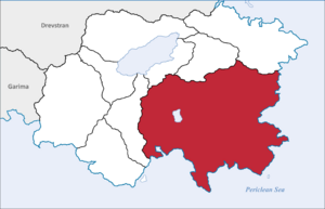
 Location of Waldreich in Brumen | |
| Country | |
| Proclamation of Waldreich | Winter 511 CE |
| Hoffman Reformation | Summer 860 CE |
| Articles of Union | 10th June 1305 |
| Founded by | Thorsten I |
| Capital & Largest City | Dinsmark |
| Administration | TBD |
| Government | |
| • Type | Parliamentary Constitutional Monarchy |
| • Body | State Government of Waldreich |
| • Monarch | Queen Anne-Marie I |
| • Premier | TBD |
| • Deputy Premier | TBD |
| • Legislative Body | Reichkammern of Waldreich |
| Area | |
| • Total | 120,448 km2 (46,505 sq mi) |
| • Land | 116,300 km2 (44,900 sq mi) |
| • Water | 4,148 km2 (1,602 sq mi) |
| • Rank | 1st |
| Highest elevation (Mount TBD) | 2,721 m (8,927 ft) |
| Population (January 2020) | |
| • Total | 9,952,102 |
| • Rank | 1st |
| • Density | 83/km2 (210/sq mi) |
| • Rank | 1st |
| Demonym | Victorian |
| Postal code | WAL |
| GRP (Nominal) | $273 Billion |
| GRP per capita | $27,492 (1st) |

