Yajawil of Xukaj: Difference between revisions
mNo edit summary |
No edit summary |
||
| Line 129: | Line 129: | ||
==Etymology== | ==Etymology== | ||
==Geography== | ==Geography== | ||
The region features two of the longest rivers in the Mutul, the [[Kuwajuwa]] and [[Chetzaj]] rivers, on the shores of which humans have settled since prehistoric times. The natural vegetation of the region has for the most part dissapeared and survive mostly in the more mountaineous area. In the rest of the country, the dominant form of agriculture allowed by irrigation canals fed by water from the two rivers has heavily altered the environment of the province. | |||
===Climate=== | |||
Most of the Viceroyalty has a {{wp|Tropical monsoon climate}}, a tropical climate with a short dry season and heavy rainfall for the majority of the year. In the Köppen climate classification, it is classified under the letters Am. {{wp|Tropical rainforest}} is the natural vegetation, and also provides the other climate type located in the state. | |||
==History== | ==History== | ||
==Politics== | ==Politics== | ||
Revision as of 21:03, 17 November 2022
Yajawil of Xukaj | |
|---|---|
| Motto: United Voices | |
| Anthem: Hymn for the Communion | |
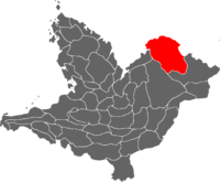
 Location of Xukaj in the Mutul | |
| Capital and | Puylum |
| Official languages | Mutli |
| Recognised national languages | |
| Ethnic groups (2020) | |
| Demonym(s) | Xukajeses |
| Government | Absolute monarchy |
| Legislature | Chika Holpop |
| Chika Sajal Ch'ob | |
| Chika Mam Ch'ob | |
| Province of the Mutul | |
| Area | |
• | 138,512 km2 (53,480 sq mi) (2nd) |
The Yajawil of Xukaj is one of the two southernmost provinces of the Mutul. Centered around the lower beds of the Kuwajuwa and Chetzaj rivers, its capital Puylum is located at the mouth of the former on the Kayamuca Sea' coast. It shares a land border with the kingdom of Orun Redisus to the east as well as with the other Mutuleses provinces of Nolkaj to the south-east, Yajumel to the south-west, and Jalchi to the west. It is the second largest Viceroyalty of the Mutul, right behind its neighbor Yarumel (162,016 km²).
The original inhabitants of the Province were speakers of various Chibchan languages of which Dule and U'wa peoples are modern representatives. The region is known as an important agricultural and industrial center for the Divine Kingdom with strong commercial relations with its neighbor, other countries in the Kayamuca Sea, and Sante Reze.
It is a very ethnically diverse region where the dominant Ch'olti culture only arrived during the 14th century and wouldn't become the norm until the 1800s. This leave the region as home to different White Path denomination and temples, many of which find their roots in the antique Chibchas religious practices which put the emphasis on the Voice, generally through religious songs and oral traditions.
Etymology
Geography
The region features two of the longest rivers in the Mutul, the Kuwajuwa and Chetzaj rivers, on the shores of which humans have settled since prehistoric times. The natural vegetation of the region has for the most part dissapeared and survive mostly in the more mountaineous area. In the rest of the country, the dominant form of agriculture allowed by irrigation canals fed by water from the two rivers has heavily altered the environment of the province.
Climate
Most of the Viceroyalty has a Tropical monsoon climate, a tropical climate with a short dry season and heavy rainfall for the majority of the year. In the Köppen climate classification, it is classified under the letters Am. Tropical rainforest is the natural vegetation, and also provides the other climate type located in the state.