User:Latium/Sandbox3: Difference between revisions
No edit summary |
No edit summary |
||
| Line 45: | Line 45: | ||
| blank_info_sec1 = Saint PLACEHOLDER | | blank_info_sec1 = Saint PLACEHOLDER | ||
}} | }} | ||
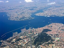
'''Leonopolis''' is the largest city and administrative center of the [[Perateia|Diocese of the East]]. Leonopolis is a transcontinental city, straddling the Alcaean Straits separating | '''Leonopolis''' is the largest city and administrative center of the [[Perateia|Diocese of the East]]. Leonopolis is a transcontinental city, straddling the Alcaean Straits separating [[Ajax#Scipia|Scipia]] and the Chersonian peninsula. The city is coterminous with the province of Leonopolis. The city holds a strategic place between the Periclean Sea and the Ozeros Sea. | ||
It was first founded in the | It was first founded in the 3rd century BCE as a Hellenic colony named Alcaea. It was re-established as Leonopolis in the early 4th century by [[Iovanius, Latin Emperor|Latin Emperor Iovanius]], where it became a major city in the east of the ancient Latin Empire. In the 7th century it was conquered by the [[Azdarin|Mesfin Caliphate]], and in the 10th century incorporated into the [[Bayarid Empire]]. Leonopolis served as the capital of [[Vardana]], under the name, Aparan, intermittently between the 5th and 8th centuries, again from 1353 to 1534 during the first [[House of Hazaraspid|Hazarasp period]] and again from 1624 to 1830. | ||
=Awonibi= | =Awonibi= | ||
{{Infobox country | {{Infobox country | ||
Revision as of 23:05, 22 February 2020
Leonopolis | |
|---|---|
City | |
| Colonia Castellum Augusta Nova Alba Civitas Claudii | |
 From top, clockwise left to right: | |
|
Official seal of Leonopolis Coat of Arms | |
| Nickname: Pons Orbis Terrarum (Bridge of the World) | |
| Country | |
| Caesarian Province | Perateia |
| Prefecture | Perateia |
| Diocese | East |
| Subdivisions | 15 districts |
| Established | AD 341 |
| Founded by | Iovanius I |
| Government | |
| • Type | Mayor–council |
| • Body | City Assembly |
| • Vicar | TBD |
| • Mayor | David Varazhnuni |
| Population (2017) | |
| • City | TBD |
| • Rank | Xth in Latium |
| • Urban | TBD |
| Time zone | UTC+3 (EBT) |
| Patron Saints | Saint PLACEHOLDER |
Leonopolis is the largest city and administrative center of the Diocese of the East. Leonopolis is a transcontinental city, straddling the Alcaean Straits separating Scipia and the Chersonian peninsula. The city is coterminous with the province of Leonopolis. The city holds a strategic place between the Periclean Sea and the Ozeros Sea.
It was first founded in the 3rd century BCE as a Hellenic colony named Alcaea. It was re-established as Leonopolis in the early 4th century by Latin Emperor Iovanius, where it became a major city in the east of the ancient Latin Empire. In the 7th century it was conquered by the Mesfin Caliphate, and in the 10th century incorporated into the Bayarid Empire. Leonopolis served as the capital of Vardana, under the name, Aparan, intermittently between the 5th and 8th centuries, again from 1353 to 1534 during the first Hazarasp period and again from 1624 to 1830.
Awonibi
Kingdom of Awonibi | |
|---|---|
Flag
Coat of Arms
| |
| Motto: Motto in native language ("translation") | |
| Anthem: Anthem in language translation | |
| Location of Awonibi (blue) – in Scipia-Malaio (dark grey) Location of Awonibi (blue) – in Scipia-Malaio (dark grey) | |
| Political Map of Awonibi Political Map of Awonibi | |
| Capital | CITY |
| Largest largest city | Odi |
| Official language | |
| Recognized languages |
|
| Ethnic groups (2019) |
|
| Religion | See Religion in Awonibi |
| Demonym(s) | Awonibiti |
| Government | Federal absolute monarchy |
• King | Duro |
• Office | NAME |
| Legislature | Senate |
| Formation | |
• Event | 632 CE |
• Event | 1314 |
• Latin occupation | 1602 |
• Republic declared | 1946 |
• Monarchy established | 1971 |
| Area | |
• | 8,352 km2 (3,225 sq mi) (nth) |
| Population | |
• 2020 estimate | 2,200,000 |
• 2019 census | 2,180,084 |
• Density | 263.4/km2 (682.2/sq mi) |
| Currency | Denari ($) (AWD) |
| Date format | dd/mm/yyyy (AD) |
| Driving side | left |
| Calling code | +679 |
| ISO 3166 code | AW |
| Internet TLD | .aw |