Girbeta: Difference between revisions
| Line 152: | Line 152: | ||
:''Main Articles: [[Governorates of Girbeta]], [[National cities of Girbeta]]'' | :''Main Articles: [[Governorates of Girbeta]], [[National cities of Girbeta]]'' | ||
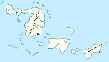
Following the establishment of the 1976 Amendments to the Girbetese Constitution and the accompanying redefinition of the nation's subnational borders, Girbeta has been comprised of nine [[Governorates of Girbeta|Governorates]], three [[National cities of Girbeta|National Cities]], and one territorial administration. Governorates and National Cities are generally autonomous in the conduct of their politics and internal governance, though they rely on the federal government in order to gain resources for allocation to programs and services. These subnational units are not comparable in terms of population, and allocations by the federal government are thus based on population figures, which are adjusted every census year, with the next reappraisal to take place in 2021. <div style="float: left;margin:0 2em 0 0;">{{Girbeta labelled map}}</div> | Following the establishment of the 1976 Amendments to the Girbetese Constitution and the accompanying redefinition of the nation's subnational borders, Girbeta has been comprised of nine [[Governorates of Girbeta|Governorates]], three [[National cities of Girbeta|National Cities]], and one territorial administration. Governorates and National Cities are generally autonomous in the conduct of their politics and internal governance, though they rely on the federal government in order to gain resources for allocation to programs and services. These subnational units are not comparable in terms of population, and allocations by the federal government are thus based on population figures, which are adjusted every census year, with the next reappraisal to take place in 2021. <div style="float: left;margin:0 2em 0 0;">{{Girbeta labelled map}}</div> | ||
===Law and Order=== | ===Law and Order=== | ||
===Military=== | ===Military=== | ||
Revision as of 16:45, 18 May 2020
This article is incomplete because it is pending further input from participants, or it is a work-in-progress by one author. Please comment on this article's talk page to share your input, comments and questions. Note: To contribute to this article, you may need to seek help from the author(s) of this page. |
Tichvaist Union of Girbeta ⲃⲉⲣⲗⲉⲭⲧⲏⲭϥⲁⲓⲥ ϣⲓⲣⲃⲉⲧⲁⲥ Berlekthichfaiyk Jiyrbetäk (Girbetese) Union Tichvaiste Jourbetique (Mirician) | |
|---|---|
| Motto: "ϥⲏⲣⲉϣⲧⲗⲁⲣⲅⲁ ϭⲁⲕⲣⲉⲓⲩ" "An Appeal to the Angels" | |
| Capital and largest city | Saybäketle |
| Official languages | Girbetese, Mirician |
| Recognised regional languages | Regional languages in Girbeta |
| Ethnic groups (2011) | 61.4% Babarik 26.6% Loaloa 8.2% Other Jabattan Islander 3.9% Majulan 0.1% Other |
| Religion | Tichvaism |
| Demonym(s) | Girbetese |
| Government | Federal multi-party ecclesiocratic-republican semi-presidential republic |
| Moushira Sabbagh | |
| Teremun Shalhoub | |
| Legislature | National Consultative Assembly |
| Chamber of Elders | |
| Chamber of Deputies | |
| Formation | |
• Settlement by the Girbetese | c. 1430 CE |
• Tichva Confederacy | 1450-1602 |
• Colony of Miricia | 1602-1866 |
• Kingdom | 18 August 1866 |
• Tichvaist Union | 5 October 1957 |
| Area | |
• Total | 180,386,941 km2 (69,647,787 sq mi) |
• Water (%) | 2.4 |
| Population | |
• 2019 estimate | 65,005,659 |
• 2011 census | 62,505,442 |
• Density | 2.88/km2 (7.5/sq mi) |
| GDP (PPP) | 2019 estimate |
• Total | 1,063,905,128,282 US$ |
• Per capita | 17,021 US$ |
| GDP (nominal) | 2019 estimate |
• Total | 430,162,451,844 US$ |
• Per capita | 6,882 US$ |
| Gini (2016) | low |
| HDI (2017) | very high |
| Currency | Girbetese Bakir (GIB) |
| Date format | dd/mm/yyyy |
| Driving side | right |
| ISO 3166 code | GI |
| Internet TLD | .gi |
Girbeta (Girbetese: ϣⲓⲣⲃⲉⲧⲁ, romanized Jiyrbetä), officially the Tichvaist Union of Girbeta (Girbetese: ⲃⲉⲣⲗⲉⲭⲧⲏⲭϥⲁⲓⲥ ϣⲓⲣⲃⲉⲧⲁⲥ, romanized Berlekthichfaiyk Jiyrbetäk), is a transcontinental country with inhabited territories in both Rennekka and Frigidarum.
Though its culture is heavily defined by its Tichvaist Babaro-Girbetese (Babarik) heritage, Girbeta's history is also richly influenced by the Loaloa peoples, who migrated into the region sometime around the 11th Century CE. As knowledge of the Jabbattan Islands extended into the Eastern Hemisphere, the Tichvaist community among the Babariks, facing a renewed wave of religious persecution, began migrating further south down the Western Coasts of Majula before making expeditions into the region in the 13th Century, formally settling the island of Jar and establishing what would become the modern capital city of Saybäketle, which would gradually become the primary locus of cultural importance to the increasingly-multicultural Girbetese, with the Loaloa and Babarik cultures slowly blending through a mutual importance placed on the highly syncretic Tichvaism, facilitating the expansion of the Great Southern Confederacy across most of the modern landmass controlled by Girbeta by 1600. With the onset of the Age of Exploration carrying out across the globe by the end of the 15h Century, Girbeta was uniquely positioned as a prime commercial center between the hemispheres, leading to a rise in foreign influence over the often-fractious city-states which comprised the Confederacy. This would gradually lead to the dismemberment of the Confederacy, ending with the conquest of Jar after a prolonged siege of Saybäketle, which helped to spark the development of the Girbetese national identity. Under the colonial domination of Miricia, attempts were made to dismantle Tichva among the islands, which only served to increase resistance to the foreign presence in the territory. After a failed but violent revolt in 1801, a number of reforms were made, leading to the establishment of a semi-independent kingdom in 1866. Full independence would be achieved in 1951, though would be quickly followed by increasing civil disobedience in response to rampant corruption of the colonial government, many of which's institutions were still firmly in place post-independence. This led to a series of mass strikes in 1955, alongside increasingly violent police actions. This spurred many governmental agencies to act against the Crown, culminating in the military siding with the Dissenters at the end of that year, forcing the King to abdicate. this would lead to significant political violence through the rest of the decade, though would end in the peaceful adoption of a new constitution, which formed the basis of the modern Tichvaist Union.
Girbeta's political system is a unique blend of a multiparty semi-presidential democracy and ecclesiocracy, with a popularly-elected head of state, and two co-heads of government - with the head of the lower house elected from outside the clergy, and the upper house appointed from within. Despite this, after significant reforms in the latter quarter of the 20th Century, Girbeta is described as an open society, which shares many of the same features of other modern secular, liberal nations. However, in the present, the country still struggles to overcome a long history of sectarian violence, inter-ethnic tensions, and economic underdevelopment rooted in its history under colonial rule. Despite these shortcomings, Girbeta has a high degree of income equality and a high Human Development Index score, as well as being a world leader in green energy development.
Etymology

The Girbetese name ϣⲓⲣⲃⲉⲧⲁ (Jiyrbetä) has been in recorded use since the settlement of Saybäketle. The commonly-used folk etymology of the name is "The Place where the land runs out", citing a common saying among the Girbetese on the condition of their culture over the course of history: "Our people are at home at the edges of the world. We are the tree on the cliff, the only thing that survives where the land runs out." The precise origin and chronological placement of this statement is unknown, but is purportedly used around c. 1400 CE, with Girbetese historians generally believing it to be first utilized prior to the Exodus from Majula.
During the earlier phases of settlement by the Girbetese, the term ϩϣⲁⲣⲓⲣ (Jahriyr), translating to "shoreline", "fringe", or "distant place" was also utilized in reference to the eastern settlements of the modern country in particular. This was in reference, likewise to its current name, to the land's place as being on the most distant known lands at the time. Today, this nomenclature endures through the modern Jar Governorate.
As per the 1952 Constitution, the official name of the nation is Berlekthichfaiyk Jiyrbetäk(the Tichvaist Union of Girbeta).
Geography
Mannatiua is an island chain in the Southern [ATLANTIC] Ocean, and is part of the Greater Babaran Archipelago. Forty of these islands are permanently inhabited, though altogether a total of around 700 islands and cays are present in the nation's territorial waters. Roughly 80% of the population resides on the "five crowned heads", the five largest islands in the nation - Jar, Kamatiyk, Lefu Buka, Loaloadan, and Kiyryagiynčy, from east to west, respectively. The largest island, Loaloadan, is also the largest in the Archipelago. The capital city of the nation, Saybäketle, is located on Jar.
Climate
History
Pre-Exodus Girbeta
The Babaran Exodus
Early Girbeta
- First settlements in modern territory around 1430
Confederacy
- Defense of Saybäketle in 1601 becomes a legendary moment in the nation's history, begins the cementing of the Girbetese national identity
Colonial Era
Kingdom of Girbeta
- Kingdom becomes a Dominion of [COLONIZER] in 1866
- Treaty of [CITY] formalizes the full independence of Girbeta in 1920
- Royalty implicated in serious financial crimes related to sales of oil exports
- Military sides with protesters in 1955, military brass demands abdication of the monarch
- Very little foreign support for the monarchy, perceptions of low legitimacy following the widespread pervasiveness of [SCANDAL] in the royal government, as well as excessive use of police forces to track and suppress dissenters
Transitional Period
- First elections in 1956
- Last major outbreak of pro-monarchy violence brought to an end in 1959
Tichvaist Union
- Concerns on the rise over the power of the clergy start almost immediately after the ratification of the Constitution, with secularists calling for major land and officeholding eligibility reforms and the establishment of a more co-equal relationship between the clergy and general public in national politics through a more empowered secular executive
Contemporary Girbeta (1977-Present)
- Executive Commission established as a separate governmental branch in the 1976 Reforms, put into effect in 1977
- Moushira Sabbagh becomes first transgendered individual to gain a role as head of state in the world in 2019.
Government and Politics
Administrative Divisions
- Main Articles: Governorates of Girbeta, National cities of Girbeta
Following the establishment of the 1976 Amendments to the Girbetese Constitution and the accompanying redefinition of the nation's subnational borders, Girbeta has been comprised of nine Governorates, three National Cities, and one territorial administration. Governorates and National Cities are generally autonomous in the conduct of their politics and internal governance, though they rely on the federal government in order to gain resources for allocation to programs and services. These subnational units are not comparable in terms of population, and allocations by the federal government are thus based on population figures, which are adjusted every census year, with the next reappraisal to take place in 2021.


