Chaak Muknal: Difference between revisions
No edit summary |
No edit summary |
||
| Line 8: | Line 8: | ||
The name, "Chaak Muknal", means in [[Mutli]] "Tomb of {{wp|Chaac|Chaak}}". This is a reference to local myths which says that, after Mamlab, the elder version of the god Chaak, dies, his body is charried to the bay which thus serve as the resting ground for the god of rains and storms until he is reincarnated once more. An event materialized by the arrival of the rainy season. | The name, "Chaak Muknal", means in [[Mutli]] "Tomb of {{wp|Chaac|Chaak}}". This is a reference to local myths which says that, after Mamlab, the elder version of the god Chaak, dies, his body is charried to the bay which thus serve as the resting ground for the god of rains and storms until he is reincarnated once more. An event materialized by the arrival of the rainy season. | ||
==Regions== | |||
Among locals, the Chaak Muknal can be divided in a number of subregion. On the northwest bank of the bay, the '''Ilachak swamp''' is an important, low-raising, area covered in seasonal and permanent humid zones and swamps, with only a few small hills and islets rising above the mud. It's on two such hills that the capital [[K'alak Muul]] was originally built on, with surrounding swamps being first used for agriculture and then dried to allow for more constructions. Today it's the densest region and has, for the most part, become synonymous with the Capital. | |||
Further west, the [[Uka river]] run through the {{wp|Manche Ch'ol|Aj Man Te'}} homeland, a more elevated region of wooden hills and speculative agriculture specialized in the production of chocolate, cotton, and vanilla. | |||
[[category:Mutul]] | [[category:Mutul]] | ||
Revision as of 18:41, 11 June 2020
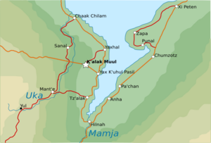
The Bay of Chaak Muknal, officialy refered simply as Chaak Muknal and colloquially as the Ch'olxi Area or Capital Bay, can be used indiscriminately to refer to either the inlet of the Kayamuca Sea indenting the Mutul coastline, or to the populous region, densely urbanized, region surrounding the very same inlet. Although the exact boundaries of the region vary, it is generally considered to be delimited to the north-west by the Uka river and the Ch'ol mountains's foothills. It's southern border with the Apikal Valley is more problematic, but the town of Hilnah is always considered to be the southernmost city of the Chaak Muknal Area. The border with the Xinka coast can also vary widely depending on the author. Some consider that it is located at Chumzotz, while other say its Xi Pasil that is the limit between the two geographic areas. How deep inland the Chaak Muknal area goes is also subject to change from author to author.
In its most conservative estimates, the nine Batabilob that form of the core of the area are home to approximatively 9 millions people, matching the closely the metro-area of K'alak Muul. There is no administrative authority in charge of the Bay, as it is divided between many Kuchkabals and three Ajawils : Uka, Mamjamil, and Xik'ab. The population is very diverse, with migrants from all around the Mutul attracted by the possibilities offered by the proximity with the Capital.
The Chaak Muknal is also one of the most industrial area of the Divine Kingdom, and Yax K'uhul Pasil is one of the busiest port of Oxidentale this important economic activity has led to pollution, destruction of natural habitats, and other ecological problems. The bay's waters are some of the most polluted in the world which resulted in the extinction of many Endemic species and the disparition of many populations. Efforts have been made by the various local authorities to reduce the pollution, but progress have been minimal.
The name, "Chaak Muknal", means in Mutli "Tomb of Chaak". This is a reference to local myths which says that, after Mamlab, the elder version of the god Chaak, dies, his body is charried to the bay which thus serve as the resting ground for the god of rains and storms until he is reincarnated once more. An event materialized by the arrival of the rainy season.
Regions
Among locals, the Chaak Muknal can be divided in a number of subregion. On the northwest bank of the bay, the Ilachak swamp is an important, low-raising, area covered in seasonal and permanent humid zones and swamps, with only a few small hills and islets rising above the mud. It's on two such hills that the capital K'alak Muul was originally built on, with surrounding swamps being first used for agriculture and then dried to allow for more constructions. Today it's the densest region and has, for the most part, become synonymous with the Capital.
Further west, the Uka river run through the Aj Man Te' homeland, a more elevated region of wooden hills and speculative agriculture specialized in the production of chocolate, cotton, and vanilla.
