Portal:Garetolia/Article: Difference between revisions
No edit summary |
No edit summary |
||
| Line 1: | Line 1: | ||
<div style="float:left;margin:0.5em 0.9em 0.4em 0;"> | <div style="float:left;margin:0.5em 0.9em 0.4em 0;">{{Garetolia Island Map (small)}}</div> '''[[Cona]]''', formerly known as '''Ule Island''' is the largest and most inhabited island of [[Garetolia]]. It was discovered in 1775 by {{wp|James Cook}}. At nearly 6,000 square miles, it serves as the population hub for Garetolia, as most national parks and metropolitan areas are on the island. It's largest export is {{wp|potassium}} and {{wp|calcium}}. Containing 5 [[Counties of Garetolia|counties]], and over two thirds of the country's population, it is usually divided into two parts: Kona Ni'i, the larger, more populous part, and Kona Iti, the smaller eastern part. The Breton Peninsula on the east coast has a striking similarity in appearance to that of {{wp|Great Britain}}. | ||
In 1973, there were mass riots for indpendence, so the {{wp|British Government}} gave the island of Cona and the 5 counties semi-autonomy, as a collective region of the Dominion of Garetolia. | |||
Revision as of 04:35, 12 September 2020
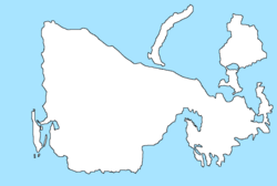
Cona, formerly known as Ule Island is the largest and most inhabited island of Garetolia. It was discovered in 1775 by James Cook. At nearly 6,000 square miles, it serves as the population hub for Garetolia, as most national parks and metropolitan areas are on the island. It's largest export is potassium and calcium. Containing 5 counties, and over two thirds of the country's population, it is usually divided into two parts: Kona Ni'i, the larger, more populous part, and Kona Iti, the smaller eastern part. The Breton Peninsula on the east coast has a striking similarity in appearance to that of Great Britain.
In 1973, there were mass riots for indpendence, so the British Government gave the island of Cona and the 5 counties semi-autonomy, as a collective region of the Dominion of Garetolia.
